I obviously enjoy cycling in The Netherlands, but it is always worth getting back on foot to gain other perspectives and in this post, I report on a junction in Leiden that I walked around.
My last two trips have involved cycling between places and so after a few hours in the saddle, it is nice to get off the bike to walk around. While cycling allows lots of ground to be covered at a (quick) human pace, walking allows us to pick up more detail, the nuances and sometimes the atmosphere.
The junction of Koninginnelaan with Herenstraat and Leuvenstraat isn't particularly atmospheric, but it's an interesting place to walk around and to observe. Situated in the Tuinstadwijk neighbourhood, it's just a kilometre south from the centre of Leiden, but is more suburban in nature and it's name is shared with a type of development loosely based on the "garden village".
The junction is actually a crossroads. The eastern arm is a dual carriageway with one lane in each direction with advisory cycle lanes and car parking beyond - just what we wouldn't want to see on a street like this. While it's a dual carriageway, it's more of a suburban boulevard which we can find in many places, include the UK and which has this garden village feel.
To the west, the area is a filtered neighbourhood. South is a single carriageway road with advisory cycle lanes and parking beyond with left turn pockets within traffic islands which feels similar to the UK. North is street with a local centre feel, but which provides a direct driving route to the city centre and as such is traffic calmed, but probably more of a secondary traffic route as there are easier driving routes elsewhere.
As it stands, the eastern and southern arms are the main drag which changes from the dual to single carriageway, have zebra crossings and which also has to accommodate the quieter northern and western arms. If this were left as a bend in the road, then the two quieter roads would have awkward interfaces and left turns would be across traffic. Throw in the cycle lanes on each side, bus stops in laybys and pedestrian desire lines and we'd have quite a lot going on.
In Dutch style, the junction appears complex, but it actually breaks things down into easy bites for all users. Even before the current layout, the northern arm of Herenstraat required drivers leaving to turn right, although a gap in the central reserve opposite the eastern arm appeared to allow drivers to chance a U-turn. Cycle traffic could turn left with some protection (but not prioritised) in the centre of the road (below, from 2014, being a bit clearer than 2009. From the north looking south). Leuvenstraat did allow left turns, but these would be far fewer.
I don't know if this is the original layout from when the area was built, but requiring general traffic to turn right means that the quieter streets behind have a level of filtering to make them less about through traffic. This layout objectively creates some problems for cycling on the main road where the fairly tight turn required drivers to give proper space otherwise people cycling would be "pinched", especially north going west (below).
I've not managed to get to the bottom of it, but from reading about the junction on the sleutelstad.nl website, plans to change the junction in 2019 were controversial. Some citizens and business were concerned that changes meant further to drive because of further restrictions to where drivers could turn. It just shows that even in The Netherlands, drivers are resistant to change and businesses are concerned about changes which make driving to them more awkward which is the mode they overestimate that people use to visit them.
From what I can work out, a redesigned junction opened in stages, but for cycling in the summer of 2020. Since then, the rumblings of discontent have continued with the local residents' association complaining about an increase in collisions and near misses along with damage to cars, and apparently an independent study is being undertaken. I clearly don't know the detail and nuance of this, but there is a pattern here familiar to the UK and perhaps the real issue in part is the new layout prioritising cycling and walking over driving.
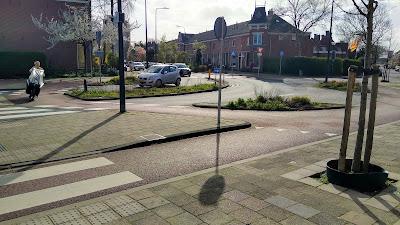
So what does the junction look like? In common with other parts of the country and elsewhere in the Leiden municipality, there is a push to prioritise cycle traffic over motor traffic in many urban circumstances and so the junction now has a fietsrotonde or cycle roundabout anticlockwise around the outside of general traffic with the eastern and southern zebra crossings maintained. The photograph above shows the layout from south looking to the east.
Cycling on the main south to east axis now has protected cycle tracks which removes the risk of people cycling being pinched and the bus stops have been floated which both creates space for cycle tracks and means stationary buses will hold following traffic so that there is no need for bus drivers to worry about rejoining the traffic stream. The road running through the middle of the roundabout is reminiscent of a hamburger junction.
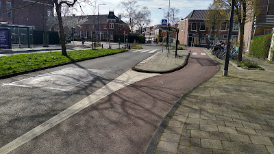
The other thing is being a roundabout for cycle traffic, the flows crossing the main arms are prioritised as we'd see on a complete urban roundabout with the cycle crossings having priority next to the zebra crossings (above from the north looking south).
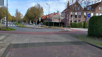
For the minor arms, we have very familiar entrance kerb type treatments which are set up to allow people cycling to move from the mixed traffic arrangements of the quieter streets to the cycle tracks (above - view to the east from Leuvenstraat).
The key change for the two side streets the required right turn which could lead to some people driving south and bit and then performing a three point turn to head north and then east again. The only other issue was I saw a few people turn left from Herenstraat into Leuvenstraat on the footway which is problematic given the visibility there. My guess was they were avoiding drivers turning left into Herenstraat who were moving too quickly.
So there we are. A layout which looks quite odd and complex, but which as usual breaks it all down to control how people in the three modes cross each other. When viewed through that lens, it doesn't actually look that complicated.


Always enjoy your reviews, and get a greater appreciation of the number of factors to be considered. In this case how the floating bus stops not only improve cyclist/passenger interactions but can be used to control traffic.
ReplyDeleteThanks! Funnily enough, I only realised the traffic control element of the bus stops when I was writing the post!
DeleteThe article mentions advisory cycle lanes probably because of the non-continuous line seperating the road and the lane. That however tells only car traffic that it may pass the line.
ReplyDeleteThe difference between advisory and obligatory cycle lanes in the Netherlands is based on the presence of a cyclist symbol in the lane. Official that symbol should be repeated every 30 meter.