Friday, 11 December 2015

London Cycling Infrastructure Safari Part 2: Cycle Superhighways (Quality May Vary)

Last week I reported on the Waltham Forest Mini Holland leg of the first London Cycling Infrastucture Safari which took place a couple of weeks back in association with the Cycling Embassy of Great Britain.

This week, we have the second part which concentrates on a few things we saw on the new Cycle Superhighways under construction. I didn't get many photos, but did make a few videos which will be the bulk of this post and besides, the second ride will be this Sunday (13th December, start at the Old Town Hall, Stratford - from 10am) and so I hope to get a few more snaps, especially as the East-West scheme on the Embankment keeps having bits opening daily!

So, after entering the Olympic Park, we essentially rode wide shared-use paths of varying surface quality with very little to write home about. As one heads towards Stratford, there are railways and some roads which are hostile to cycling and the route to pick up CS2 isn't really signposted, but we got there. Nothing to write home about other than given the area was rebuilt for the games, it was a wasted opportunity for active travel.

We arrived at High Street, Stratford (where CS2 runs) via Carpenter's Road and was greeted with a staggered Toucan crossing. Landing on the westbound side of High Street one has to dog-leg back on one-self to get onto the cycle track which is very poor. 

I have only ridden through before and so not appreciated the awful crossing and join with the track. For pedestrians (especially for those with mobility and visual impairment) it is worse. Why can't we line things up properly?

CS2 in Stratford is a couple of years old now and of course is better than just the blue paint of the original treatment heading up to the City. The floating bus stops have 1.5 metre cycle tracks which have been specifically arranged to force people cycling into single file to aid pedestrian safety, but it all feel constrained, especially with vertical kerbs. But, it is light years ahead of cycling with traffic.

In my view, the shelters would be better with their backs on the road side and so as buses pull in, passengers would walk towards cycles to get one with clear views. Those leaving the bus would also have lots of clear space to see or be seen before they crossed the cycle track at either the humped crossing point or informally across the track.

The following is a video shot heading eastbound from the junction of Rick Roberts Way where we had to be on our toes as we are just in an ASL, so left hook is a concern. It takes in a floating bus stop and you will see how people have to go into single file. Also, we pass a pedestrian crossing where the protection ends and so we are exposed to traffic again.


We paused a while to discuss the infamous Bow Roundabout and as we watched, some people struggled to cross. It still remains unsatisfactory for cycling (as it is an "always" stop because of the signal set up), but people walking get no help. Still, some planting has been undertaken in the middle with some sculptures, so that's alright then!

After Bow, we continued towards the City, dodging roadworks and trying to avoid some awful driving. Where we were on the new cycle tracks, things weren't too bad; I have given an early view before and so I now think it is fairer to wait until it's all complete. We stopped at a couple of junctions to look at some UK innovations. 


We had a look at the 2-stage right turn at the junction of Mile End Road and Grove Road (which also has a hold the left turn for traffic) which is the UK version of a "Copenhagen Left". Essentially, the arrangement allows one to pass a green signal from within the cycle track as if one was going ahead and then stop in a marked place to wait for a green signal for cross traffic. 

The image on the right is TfL's consultation plan, but the red dots show the path after passing the ahead green for cycles (east to west on the plan) with the last two being roughly where riders wait for the second green for the traffic moving from south to north. The second stage is then the orange dots where riders move off either on the same signal as for traffic going south to north or just before with an advanced green cycle signal. It seems complicated and it is. 


The things to look out for to know what the junction arrangement is the traffic signs. The image on the left is taken from Transport for London's Special Authorisation from the Department for Transport (i.e. non-prescribed signs which TfL is now allowed to use).  

The blue sign is an advanced information sign to explain how the junction works for right turning cycles and the white circular sign is mounted on the traffic signals which those cycling see as an exemption from the standard no right turn sign which will be next to it. So far, so complicated, let's watch a group of us have a go;


So, yes  I made a hash of it, but in my defence, it was not immediately clear which signal was aimed at us to complete the turn. This is a safety problem and I would be interested to see if it was picked up by a road safety audit. The waiting area did not feel particularly safe, although probably a subject issue more than a collision-risk issue, although those cycling ahead were essentially in advisory lanes with live traffic to their right.

The problem arises with the staggered pedestrian crossing on Grove Road which is so arranged for traffic capacity reasons. Had the junction been operating with straight-through pedestrian crossings, the only signals I would have seen would have been aimed at us. If pedestrians had straight through crossings, then all traffic would have been held and we would have been able to have the Simultaneous Green that the UK rules are simply not letting us utilise. Compare with this Dutch arrangement which allows all cycle movements, no need for 2-stage turns.


In truth, TfL's engineers have done the best they can within the constraints of trying to maintain motor traffic while eliminating the left hook for those cycling. The compromise has been the 2-stage right turns and the staggered pedestrian crossings. If the compromise wasn't being made, then I doubt the scheme would have gone ahead and so it does leave a mixed feeling.

We were going to stop at Whitechapel Road and Cambridge Heath Road to study the "hold the left" (it being a UK first), but it was coned off again and we cut our losses and continued west. We reached the end of CS2 at the Aldgate gyratory and then headed off towards CS3 for the quick look. To be honest, there was not much going on, so we dived into a cafe for lunch for recharge our nerves after CS2!

After refreshments, we headed on to have a look at the works on the Embankment which will form part of the East-West Cycle Superhighway which will joint with CS3 in the east. We did pause to look at a few other things, but let's concentrate on the East-West. I am not going to say much as I think will be worthy of it's own blog when it is complete; and besides, this video tells the story so far;


Apart the the humps which have been put in to create a level crossing area for pedestrians, things are really taking shape. With those humps, I have no problem with the concept (level crossing areas are nice and accessible), just the height of the humps (over 100mm is unlawful) and the ramps are steep. I look forward to riding this when it is all complete!


The next part of our trek had us continuing east to Vauxhall to have a look as Cycle Superhighway 5 which has a nice section complete which starts on Vauxhall Bridge Road at the junction with Regency Street, crosses Vauxhall Bridge and then heads down to The Oval - a distance of about one-mile.

The whole section is on a protected bi-directional cycle track as with the Embankment. There are cycle signals of course and it is all rather wonderful. The only two real issues for me was the very long wait at a crossing just east of Vauxhall Station and that the joy ended so soon! Anyway, yet again, the video speaks volumes;


We did have a look at some other work in progress near The Oval, but it is not worth reporting on that just yet. 


We made plans to head towards Elephant & Castle (which will never be remembered without Adrian Edmondson now) with a couple of us heading back to the City and so people peeled away at various stages. 

We had a look at some of the upgrade works on CS7 which runs along the A3 with the fantastic example of a continuous footway and cycle track (uni-directional) passing Magee Street; the real key is the traffic can only leave Magee Street (being one-way) and so left-hook is eliminated. It would be nice to see a cycle contraflow here though.


CS7 also had a better example of a floating bus stop than on CS2 and it allows people to ride side-by-side which if course is a very sociable way of riding.

As we approached Elephant & Castle we stopped to have a look at some of the North-South Cycle Superhighway under construction on St George's Road (photo below) which had two-stage gives ways for motorists. Although a little narrow, they are certainly far better than people turning right in and so show a half-decent attempt to prevent left hook.


Given that they are only really stepping stones for side road access, they should work reasonably well. As we headed back, we cycled through the new layout at St George's Circus which looks like a mad signals engineer has been let loose. It will be part of the North-South route and this movement seems fine, but it needs a more in-depth visit. As our numbers dwindled, the last 3 of us crossed Southwark Bridge (which has big kerbs to protect weak parapets which also create some safe cycling space for free!).

Finally, the three of us slip up and headed our separate ways home after a long, but very interesting day out. There is some real change in pockets of London. Waltham Forest is starting to show what can be done with decent concentrated funding where primary and secondary streets need to give people cycling protection, but where local streets become good for cycling because through traffic is filtered. The Cycle Superhighways are starting to deliver proper layouts for a proper mode of transport. Yes, things are not perfect, but perhaps at last London is showing how we can make our own way. I do worry for the future as so far, there is not much pace gathering for cycling from some of the Mayoral Candidates and the UK Government remains as committed as every to blowing billions on road building. However, come the summer when lots of this stuff is nearing completion, then we will be able to point at it say "build it and they will come".

Tuesday, 1 December 2015

London Cycling Infrastructure Safari Part 1: Oases and Orcas

Last Saturday a group of us got together in association with the Cycling Embassy of Great Britain to look at some of the work in progress on the construction of cycling infrastructure in various corners of London.

This post will be the first of a series giving a flavour of what we saw, although please bear in mind that this can only be a snapshot; conditions can change at different times of the day and week! There is another safari planned for Sunday 13th December, but I think I will be starting it at Stratford thus saving a return to Waltham Forest for the Spring. The subject of this week's post is the Waltham Forest Mini-Holland scheme which is ostensibly a cycling infrastructure project, but as we saw, it is so much bigger than that. Truly a project going #beyondthebicycle.


We met up in the weak Autumn sunshine at Orford Road (myself having just guzzled tea and a bacon roll at the Village Bakery) to have a quick look around the area. Orford Road was an amazing contrast to the rotten route I had cycled from entering the edges of Stratford and up through the A112 which all were traffic sewers with parking everywhere.

Orford Road was quiet and calm and the small collection of cafes had people using the chairs and tables placed outside. The scheme on the ground was taken forward after an experimental scheme to ban motor traffic during the day (apart from a local bus route) and I was sent a link to a video after the ride which shows what things were like immediately after the trial ended and the traffic let back in. How anyone would want to go back is beyond me.


The street has been relaid as a level surface shared space with motors only allowed through after 10pm at night and before 10am in the morning and the street is one way to motors and 2-way for cycles (I understand there is CCTV enforcement).

The work is finished to a high standard with good quality paving materials for the main walking routes. The area on which traffic runs is a tidily laid asphalt surface. Buses can come through during the restricted times and other vehicle outside of these times, although I thought the asphalt area to be a little narrow for larger vehicles and there were a few maintenance issues appearing.


The street has a 20mph speed limit and is part of a much larger (and older) 20mph Zone. There were some nice touches such as the lighting columns facing the "wrong" way to illuminate the main walking routes rather than the "carriageway" section. I don't know how visually impaired people find the street and I would be very interested to know.


The other end of the street is "no entry, except cycles" which works just fine. The other end of the street has incorrect signage in my view however. A white circular sign with a red edge means no vehicles and that technically means cycles. I think this needs to be looked at again and made a pedestrian zone or a pedestrian and cyclist zone when the rules finally catch up. I am not even sure that a one way is required, a no entry and one end makes that the case by default. These may be little issues, but I like to see these details done correctly.


Business needs are not neglected with a large loading bay provided at one end of the street. Yes, people will need to walk goods using a trolley. I am not sure what the demand is, but we did see a couple of small vans sneak in to deliver and I wonder if allowing deliveries during the banned period would be such an issue?


Just off Orford Road, a side road has been closed to traffic (Eden Road) and the space combined with a tatty old planted area to create "Walthamstow Village Square" and very nice it is too. The main walking route is paved the same as Orford Road and the open space finished in self-binding gravel which is an awful lot cheaper - a big impact to a budget! The "village" concept is a theme of the Waltham Forest Mini-Holland programme which splits the borough and the work into village themes and from what we could see, things were moving in the right direction. We'll leave the Village with a little video.


Beyond Orford Road, we had a quick look at a motor traffic filter in the form of a railway bridge carrying West Avenue Road. If you look back in time, you will note that the edge of the carriageway was lined with vehicle containment barriers and this is because either the footways on the bridge or the parapet (walls), or both, were under-strength. Closing the bridge to motors has essentially removed the loading risks to the bridge and the area re-purposed as a motor traffic filter and pocket park; two jobs for the price of one!


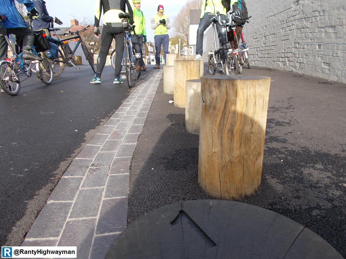
We noticed a series of numbered bollards on the bridge and when I started hopping between them, their use was immediately obvious; a cheeky bit of street play for kids walking along - it will send the health and safety brigade reaching for their hi-viz and clipboard (I think it is wonderful, even as a trained road safety auditor!)


The closure to motors is part of a wider network of filters which are laid out to prevent or discourage (by making vehicle routes very long) driving through the area, thus leaving it quiet for walking and cycling, but maintaining access for those living and working in the area who need to take vehicles in. This essentially reclassifies this as a network of local streets.


Not all of the works to filter through motor traffic from the area are high cost. This example at Copeland Road simply uses a bit of asphalt, some bollards and trees to do the job (although the dropped kerbs were not properly flush - attention to detail please guys). The timber planters a left over from the original experimental scheme and I assume they will be reused at the experiment. 

So far, this post has not shown any cycling infrastructure other than an "except cycles" sign and this is an important point. Local streets do not need any specific cycling infrastructure, just the removal of heavy and fast through traffic. This is a way of recreating places for people walking too, kids can play in the streets, people can hear each other speak and the pollution and traffic danger is reduced substantially. In the example of Walthamstow Village, Waltham Forest has spent the big money well, in places where people will want to be, but also very little money in other places to remove the unwanted motor traffic.

So, let's have a look at some cycling infrastructure. Our brief whizz around the area took us to Ruckholt Road. Nominally a secondary street (A106), it is part of a wider and more complicated set of one-way systems and loops which permeate the wider area. 


The first section we looked at was a conversion from an advisory cycle lane approaching a junction with an advanced stop line to a mandatory cycle lane protected with "light" segregation in the form of "Orcas". The old cycle lane has been widened by taking a section of footway, but the old channel block has been in which is not a great detail. The Orcas themselves don't instill the same levels of experienced safety as a kerb.

The unit is (I think) some sort of recycled plastic affair with a low profile on the cycling side and a half-battered profile (like a kerb) on the traffic side. They are bolted to the road surface, so no excavation is required. The white line of the cycle lane is on the traffic side which could be an issue for those cycling in the dark - perhaps a line on each side would be better, although that kind of becomes a double-white line road marking which isn't intended for this use.

As usual, I threw personal safety to the wind and bounced over the edges of the Orcas, although I was on my big bike and I didn't fancy it at speed. I don't know if this is the finished job or an experiment, but I cannot see it as being a long-term solution to providing protection that everyone will happy using. 

It is interesting to note that there is no lane or protection in the other direction, although this was previously the case. The other side of the road had car parking inset into the footway (and not done that long ago) which gives a stark contrast between what the borough used to do and what it is trying to do now. One issue I could see with the Orcas was they seem to attract grit and dirt which stays damp after rain which could, over time, lead to potholes forming around them.


Beyond the Orcas, we reach the junction with Oliver Road. At first, I wondered why the Orcas where in the ASL - a swine to turn right if you miss them, but there is no right turn as shown on the now (and wonderfully) common cycle signals complete with the mini ahead only sign. This lends me to think (and hope) that this is a short term scheme which will be built on in the future.


A little further west of the junction, there is some kerbed protection which runs into a floating bus stop. The layout gently ramps the single-direction cycle track up to footway level an is picked out with kerbs. It seems to have been bolted on a little to the previous layout. It is wider than others I have seen (such as CS2 at Whitechapel) and it allows one to cycle smoothly, but I think it is a bit messy and not great for pedestrians and passengers. 

There is a mini-zebra and tactile paving, but the lack of kerb upstand away from the crossing point will be an issue for some visually impaired people. I get the feeling that this is a bit of an experiment and to be honest, the experience of designing and building something is a good way of learning for many practical engineers. Let's see how it goes.


Further west, we have a slip road which leads to a retail park, industrial estate and a tangle of roads and roundabouts (i.e. local destinations rather than the A12 and M11). The whole area is a mess of roads and traffic signals and from what we could make out, there are proper kerbed cycle tracks (we didn't cycle east, so can't comment). 

The slip road uses a cycle zebra crossing (zebra for pedestrians and "elephant's feet" for cyclists). I must point out that this arrangement remains unlawful as the legislation which was going to allow it has been delayed until next year (the Traffic Signs Regulations and General Directions 2016 since you asked). At first look, it seems OK, but as we crossed, it was clear that some drivers didn't know or want to give way. The problem is that the cycle track runs with the flow of traffic and so cyclists "appear" from behind the nearside of vehicles which is made worse by trees on the approach. This crossing arrangement really needs cycles meeting the crossing at a proper 90 degree angle with an approach to intervisibility is really good.


Just a little further west we reached the junction with Orient Way where see saw some very good provision. The cycle tracks were laid out like proper little roads with decent kerb radii, cycle signals, stop lines and "elephant's footprints" to denote the crossing path to be taken by cycles. 

One little point is that the footprints should be marked outside of the crossing width. Not a massive issue, but we want to show the crossing as wide as possible.


Like many of us, the designers have been grappling with the lack of stock UK-cycling specific "forgiving" kerbs and here they have opted for small elements kerb with a 45 degree splay and an upstand of about 55/60mm. I bounced up and down them on my big bike, but they are more about preventing pedal-strike and to maximise the available width. They work fine for those reasons. I know Cambridge have been experimenting with bespoke kerbs, but we really need a proper conversion of Dutch versions to the UK and if any suppliers are reading, please have a think about this (or even get in touch).

So as we headed west, we left the emerging modern cycling infrastructure (and yes, with its faults) of Ruckholt Road as the A106 became the Eastway and we entered Hackney. Nothing to write home about here other than bollards, Toucans, shared use and roads designed for lots of traffic. We swung south through the Olympic Park and into Newham on our way to Stratford and Cycle Superhighway 2 and that, friends, will be next week's post.

Wednesday, 25 November 2015

3 Years On

It has been 3 years since I started this blog with a crazy idea of writing something every week. Well, this is post #157 and mathematically at least, I have kept to my idea.

My very first post was a bit of navel-gazing where I mused "What do we really want" and it was in response to what I had read in that month's edition of Transport Professional, the magazine of the Chartered Institution of Highways & Transportation (CIHT). I was interested in the juxtaposition of an historic idea of building more roads like the USA and the London Cycling Campaign's "Go Dutch" campaign of which I knew very little at the time. There was also thoughts on the DfT's plans to raise the rural speed limit for HGVs from 40mph to 50mph with part of the justification being drivers ignoring the 40mph limit and comment on the woeful lack of investment in our crumbling roads. 

I started the blog in response to a frustration of seeing the effects of business as usual in our urban places, frustration with politics at all levels wanting to maintain this status quo and to explore change from a professional point of view; especially where walking and cycling were concerned. My interest in walking stemmed from work I had been doing with CIHT and cycling from coming to the end of my second year of cycle commuting and putting up with the conditions myself. As a professional engineer, I have a responsibility to maintain a programme of continuing professional development (CPD) and I firmly believe that engineers have a duty to explain and educate other people in how we work and what we do.

So, then, to my highlights. My second post was about a wonderful weekend I spent in Copenhagen, where I didn't cycle, but it was still wonderful. I have managed to get round a few places such as Bruges which was a delight and Deventer which was of great interest to me given that I hadn't been to the Netherlands in over a decade (and the trip was an adventure in itself). Sadly, the overseas trips weren't to do with cycling, but I have had plenty to see in the UK. London often features in my ramblings as I am a local (although it is a huge city), but I have had the pleasure to join the Cycling Embassy of Great Britain in Brighton and Leicester for their AGMs. In the coming months, expect more kerb-nerdery from London and further afield, although this Saturday (28th November) and on Sunday 13th December, I will be leading an infrastructure safari around some interesting new London schemes in association with the Embassy.

It is on infrastructure safaris and other events where I have met some really interesting and passionate people both within my profession and other disciplines as well as tireless campaigners and advocates who are going all out to get the message out there for what we need to be doing to make our urban places liveable; and means putting walking and cycling first. There are so many people, I am not going to list them as I am bound to miss somebody! Two events of note were the launch of the Near Miss Project and an joint CIHT and London Cycling Campaign evening seminar on inclusive cycling - it was a great format and the joint meeting gave such cross-pollination.

Inclusivity is a topic I am increasingly becoming interested in. It has been there in the background when I have been thinking about transport, but it is becoming increasingly clear that those of us who want change need to engage far more with accessibility and inclusivity advocates and end users. It was brought home to me starkly when I watched the "Sea of Change Film: Walking Into Trouble" which showed how visually impaired people struggled to cope with street layouts, especially shared space (a subject I have't dared to talk about on its own as yet). 

The theme of accessibility has come up quite a bit in my technical posts which have covered subjects such as getting vehicle crossings right, traffic calming and zebra crossings. Technical posts have been a theme over the years and will continue to do so, although my post on kerbs still has the greatest number of hits ever! I am hoping some of my other posts such as the recent one on a "cycle road" will prove just as interesting, as well as my very occasional series on traffic signals. I have also seen how changes in London have developed after taking part in some off-street trials.

Beyond the infrastructure, there have been some sobering events. Last year, I attended a Stop Killing Cyclists vigil and a larger event which were times for me to reflect on how our streets influence behaviours and end up with people paying the ultimate price. If you can make it, Stop Killing Cyclists has a vigil this Friday (27th November). 

On a lighter note, there has been much fun. Whether it is Ride London which shows how wonderful a place can be with the motors kicked out (even in sideways rain over 86 miles). It is interesting to compare photos of Ride London on the Embankment with the infrastructure being built for the East-West Cycle Superhighway - every day can be ride London! Plus, I will never forget the sheer joy my family and I had at the London Kidical Mass last month (it was sunny - remember that). Yes, I am very interested in cargo bikes now! 

The final things which have interested me is the day to day stuff I am doing anyway, but where there is learning and experience I can share. Whether it is being roped in to drive a lorry, learning to ride with my cycle trailer or sneaking off from my family when on holiday to look at stuff!

What have I learned in three years? The short answer is a colossal amount and much of it from the many people I have had the pleasure to meet in person and to debate with over social media and through the blog. What of the future? Well, I think more of the same, but we will see better and better conditions for walking and cycling created with the very best being built, but I worry about what the current government is doing to active travel with its crazy road building schemes which lead to more traffic and congestion and the ever present crumbling of our local roads. We also have the threat of "business as usual" with electric vehicles and the constant deluge of stupid ideas which end up being a distraction.

Still, I must be positive. I am not a campaigner, but I think that professionals with an interest in liveable places must speak out. Not just urban fabric people such as engineers and architects, but health professionals, business people and anyone else who realises that doing what we have been doing for decades doesn't work. Building towns and cities around the motor car doesn't work and the sooner we realise this the better.

Thursday, 19 November 2015

Learning Pathway

I have been meaning to write a post about a little scheme I have been working on (a team effort). It is nothing compared to what we are seeing in places like Central London or Leicester, but it is home grown and it makes me happy.

The scheme is linked to development of several hundred homes and the where and the why is not important. What is important is that as part of the planning consent requirements, the development had to have a secondary fire access as the wider site is not permeable for motor traffic; this access was also to be provided for walking and cycling. The development has opened up new walking routes which make the wider area more permeable and cycling benefits too, although there is a shared-use path through the site which could have been much better (planning consent was granted in 2006, so modern opportunities were missed). Yes, this is a tiny scheme, but (almost) perfectly formed.

Fortunately, there was the opportunity to influence the fire access and rather than the original basic shared tarmac path, we convinced the developer and their designer to go with something a little different and unique (at least in my neck of the woods). Now, as you might realise, I am coming up to my third blogging anniversary (that will be a future post) and so I have seen one or two bits of infrastructure in that time. With this scheme I have been able to throw some ideas into the pot from things I have seen on my travels. Two things have stuck in my mind and they are a walking and cycling link in Bermondsey, London and a section of cycle track along the A48 in Port Talbot, South Wales.

Bermondsey. A nice machine-laid track, in red asphalt
and with a separate and kerbed footway. Completely
intuitive to users and nice safe space.

A48, cycle track on the left, stepped down from the
footway and the first time I had seen a 45 degree
splayed kerb used in the UK.

OK, I have been influenced by an awful lot more than just two schemes, but the basics are there and it was just a case of putting them together. OK, time to show you what we built;


Taken a while back, this shows the site corridor cleared and a capping layer laid (essentially a road foundation made from crushed rock or concrete waste). The guys on site are laying various kerbs with those either side being British Standard 45 degree splay kerbs, 255mm deep by 125mm wide. We could have actually use kerbs 150mm deep to get the same effect and this was a bit of a learning point, although they would have had a thicker capping layer below. The important point is that the capping extends beyond the kerb lines and so the kerbs are properly supported. All too often, paths are built too thin and the kerbs supported (on the usual concrete bed) directly on the soil. After a while, a crack appear along the path as things move because of the lack of support.


Further up the site, a view of the capping layer with kerbs freshly laid. The capping layer essentially helps transfer the traffic loading from the heavy duty and expensive surfacing down to the original ground which in this case is fairly soft clay. This scheme is no different to a mini road scheme in terms of design and construction. A far cry from a thinly constructed and badly surfaced shared-use arrangement.


Fast forward a few months and all of the kerbs are in and the sub base layer is in. The sub base is a higher quality than the capping (and a bit more expensive - you see theme here!) For this scheme, we used a hydraulically bound mixture (HBM) for the capping and sub base. There is a bit of science involved and the thicknesses are based on the strength of the underlying ground - yes, a mini road! HBM uses cement and some recycled soils (produced on site in this case) and acts flexibly and provides a replacement for some asphalt thickness. A good product if properly controlled and installed.


This photo shows a junction being formed with a road within an existing estate that this link connects to. The estate is very quiet and through traffic is excluded, but walking and cycling is permeable beyond the traffic filters. The junction has 2 metre radius kerbs and dropped kerbs with the usual tactile paviours. It has been suggested that this could have been a continuous footway. This is true, but there is a footway on the left and a full height kerb was appropriate opposite it to assist visually impaired people. Notice proper transition kerbs from the 45 degree splay kerbs to the dropped kerbs.


A view down the site with everything ready for surfacing. Actually, apart from forming the junction, most of this was built for months and the use of HBM meant the sub base could be left exposed to weather without needing to cover it up because of the cement content - crushed rock or concrete would have been affected by the weather.


Fast forward a little more and the job is done. This is the view on the existing street showing the little cycle junction. We had to install bollards because car drivers cannot be trusted, but they are set back 4 metres so that people on all kinds of cycle can complete their turn and the straight before they pass through.


A view along the track. The cycle logo is one of two (one at the other end) and this is the only signage to indicate that the road is for cycles (wayfinding coming in the future). The arrangement of the separate and raised footway means there is no need at all for any signage or tactile paving (apart for the junction). Nothing is needed to tell drivers to keep out, the bollards say that, along with the logos which say why! The cycle track is 3.1 metres wide (suitable for a fire path) and the bollard is 100mm wide (and removal by the fire brigade). This gives 1.5 metres of tarmac each side of the bollard. The bollards are at 1.8 metre centres


The bollards here are well back from the pedestrian route along the main street and so out of the way. We are aiming to paint some white banding for a bit more conspicuity.


The footway is 2 metres wide and the cycle track 3.1 metres wide, excluding kerb widths. The road markings are standard with 4 metre lines and 2 metre gaps approaching each end (which act as a warning) and then 2 metre lines and 4 metre gaps in the central section for guidance. Totally UK standard.


Splay kerbs with a 75mm upstand and no vertical upstand to maximise safety. All UK standard materials available off the shelf. A shallower angle would be better for potential overrun and a lower kerb face would be less likely to catch pedals, although users will be in the centre of the lanes and this won't be swarming with people - it's just a link.


Extreme close up! Some very nice surfacing skills! 


Bog standard AC10 surfacing in red for the track at 40mm thickness. There is a thicker layer of asphalt underneath for structural purposes and both are machine-laid.


Black AC10 for the footway. In hindsight, a light grey block paved footway would have looked nicer I think, but this still gives a very high level of service to pedestrians.


The other end of the cycle track connects to an area which moves from usual carriageway and footway construction to a level surface shared space which is the access to a few homes. Here, the kerb-separated footway continues on to a spine road through the wider development.


A waffle grid gully which should be standard if cycles go anywhere near it. Actually, we have found out since that we could have got a 45 degree splay kerb inlet gully - one for the standard construction details being worked on!


Closer view of the bollard. Not sure about the handles, but they are there to help with lifting out the bollard. We didn't go for a fold-down bollard as some fool always leaves it down which is a hazard.


Approaching the cycle junction at night. Might need double yellow lines to stop the stupid parking.


The whole link and night - there is a lighting column about half-way along. A good view of the second cycle logo.


Both ends of the scheme pass the trailer test easily.


Photos are one thing, but I have also made a couple of videos of the link. The first is simply a ride along the cycle track. The second spares no personal safety as I bounce my bike up and down the splay kerbs a couple of times and then try a nudge at the end. It was on the bike in the photo above. While I don't recommend it (and there is no need to go close to the kerbs with this path), they are kind of forgiving!


My colleagues and I have had fun with this scheme to be sure, but there has been wider benefits beyond people being able to use the little, 65 metre long link. Two things spring to mind.

First, we have learnt from it in terms of using the splay kerbs correctly (and yearning for a more forgiving UK standard kerb), how to do the drainage better next time (into the kerb line), playing with the red surfacing and all of the other layers which built this mini-road for cycles. We have also shown how a track of an appropriate width can be accessible for all and also, that we don't need to plaster the street in tactile paving and signs to explain how to use it, the route is completely intuitive. There is a debate in the office with the maintenance guys who are nervous about reactive repairs to the red surfacing (potholes mainly) and inevitably, they will blog black tarmac in. If the footway had been light grey, a black track would still have been fine. A black track and black footway would have done the job, but it wouldn't have looked as nice (in my view). The debate will continue, but we have built this scheme pretty bullet-proof.

The things arising from this scheme are being incorporated into some standard construction details and the scheme is influencing our thinking on other projects. To be honest, this design is very similar to what is being built in many parts of London (although we have done the kerb upstands right!)

Second, we have something tangible we can show other people when we are talking about potential new schemes and designs. Already, I have sent photos to people to explain how we want to see future links of this nature built; of course, we can also take people out on cycles to show them what a proper job looks like. Many designers are still stuck with proposing 3 metre wide hand-laid tarmac paths. This kind of design shows what is required in terms of space and specification if we are really treating cycling as a mode of transport.

But, I don't want to get ahead of myself, lots of people are building huge schemes which are doing so much for cycling. This is one scheme in a big city and it doesn't make a network, but we have to start somewhere and I don't think this is a bad scheme for moving the debate on locally. I truly look forward to the time where this type of thing has no interest to anyone, as it is standard, normal and mundane. Of course, I like to celebrate the mundane!