
In this week's post, I conclude my recent Mancunian adventure with the Cycling Embassy of Great Britain's AGM. I take a little look at some of the other interesting stuff which caught my eye.
For my visit, I stayed in Trafford, right next to some stadium or other at which I assume a football team play. I might be wrong.


Well, if it floats your boat. The thing that caught my eye was some work in progress just down the road from the stadium where the junction of Wharfside Way/ Sir Alex Ferguson Way/ Sir Matt Busby Way was being remodelled. I think it might have something to so with the Metrolink Trafford Park Line scheme, but I'd be interested to know.

In any case, the junction has been remodelled making it straight-forward for people to cycle across the wide Wharfside Way between the two side roads. It's not a pretty layout or anything particularly world-class but it is quite useful and is part of National Cycle Network Route 55. The photo above is the view looking south towards the stadium and the photo below is the view looking north towards Salford Quay.

Heading south, you are taken towards the stadium on NCN55 which passes through a plaza which I assume is part of the stadium because of the bollards either end;


After I rode through, I managed to get lost because after a couple of signs to Manchester City Centre, the wayfinding disappeared and I ended up using my smartphone to navigate. Mind you, I still found more interesting stuff.

The photo above is Phoenix Way which doesn't really make sense. It's a one-way street (south to north) with an apparent one way island protected cycle lane on the offset (also south to north). The first section also has a nearside mandatory cycle lane (see below);

It's all rather curious, but the islands offer plenty of protection. A little further north and the lane gives way to a cycle track;

The track (with the Brooks Building of Manchester Metropolitan University on the left) is again one-way and very nice to use. To the right is a drop down to Princess Road, a dual carriageway which you really don't want to cycle one!
At the end of the track, you go through a bit of shared space, apparently dismount to cross Stretford Road and then you're terrifyingly dumped in the the end of Princess Road where you get to cycle through an interchange with the A57(M)! There is north to south route for cycling on the other side of Princess Road, but in reality, both sides need to be 2-way to make in sense next to such a large road.
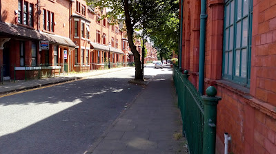
Over in Salford, we paid a visit to Coronation Street with it's solid old houses forming part of a wider and mainly filtered residential area.

Trees have been wonderfully woven into the street using build-outs into the carriageway so keeping footways clear.
At the street's western end, the filter (below) wasn't cycle-friendly and so needs upgrading. Further on, there are still fairly busy roads and so some more filtering to keep traffic on the main roads would be welcome.

The city has definitely been up for filtering schemes in the past and there are some creative layouts. Taylorson Street is at the back of the Tudor Ordsall Hall, home (there is debate) of the Gunpowder Plot.

The street is filtered with a pedestrian zone which is always in operation with exceptions for access to the residential dwellings (below).

The pedestrian zone is supplemented by an "no waiting at any time" restriction which is essentially double yellow lines done without paint and so as well as the terminal signs (as you enter and exit - used in pairs as above), there are also yellow repeater signs within the zone.

Being a pedestrian zone with the "no motor vehicles" sign, you are allowed to cycle here. And we did (fillings permitting);
Speaking of filtering, we found a bit more outside Heald Place Primary School. A few simple bollards had turned a section of Heald Place into a place for walking and cycling. The bollards and signs used to close the street to motor traffic will have cost less than the traffic calming they have made redundant (below);


I don't know the history of the street, but it's gone through the 5 stages of grief (kind of) where the old layout was just a street which it is fair to guess acted as a rat-run and lawless school drop offs, to a street with parking bays and traffic calming to try and encourage some drop off sense and finally to the acceptance that safety at the school gate should be the priority.


The last thing to show you is this temporary bridge next to Trinity Way. It was built as a service bridge as part of major rail works in the area, however, it was decided to keep it and is gives a much better alternative to cycling on Trinity Way itself.

At the southern end of the new bridge, there is an access to the towpath along the River Irwell. It's a nice design which combines steps with a zig-zag ramp dealing with the change in level.


The canal path is a good way to miss the adjacent roads, but I'm not convinced it's useful for mass cycling and the social safety is poor - that where we came in - there are big plans for walking and cycling in the city!

In any case, the junction has been remodelled making it straight-forward for people to cycle across the wide Wharfside Way between the two side roads. It's not a pretty layout or anything particularly world-class but it is quite useful and is part of National Cycle Network Route 55. The photo above is the view looking south towards the stadium and the photo below is the view looking north towards Salford Quay.

Heading south, you are taken towards the stadium on NCN55 which passes through a plaza which I assume is part of the stadium because of the bollards either end;


After I rode through, I managed to get lost because after a couple of signs to Manchester City Centre, the wayfinding disappeared and I ended up using my smartphone to navigate. Mind you, I still found more interesting stuff.

The photo above is Phoenix Way which doesn't really make sense. It's a one-way street (south to north) with an apparent one way island protected cycle lane on the offset (also south to north). The first section also has a nearside mandatory cycle lane (see below);

It's all rather curious, but the islands offer plenty of protection. A little further north and the lane gives way to a cycle track;

The track (with the Brooks Building of Manchester Metropolitan University on the left) is again one-way and very nice to use. To the right is a drop down to Princess Road, a dual carriageway which you really don't want to cycle one!
At the end of the track, you go through a bit of shared space, apparently dismount to cross Stretford Road and then you're terrifyingly dumped in the the end of Princess Road where you get to cycle through an interchange with the A57(M)! There is north to south route for cycling on the other side of Princess Road, but in reality, both sides need to be 2-way to make in sense next to such a large road.
Over in Salford, we paid a visit to Coronation Street with it's solid old houses forming part of a wider and mainly filtered residential area.

Trees have been wonderfully woven into the street using build-outs into the carriageway so keeping footways clear.


The city has definitely been up for filtering schemes in the past and there are some creative layouts. Taylorson Street is at the back of the Tudor Ordsall Hall, home (there is debate) of the Gunpowder Plot.

The street is filtered with a pedestrian zone which is always in operation with exceptions for access to the residential dwellings (below).

The pedestrian zone is supplemented by an "no waiting at any time" restriction which is essentially double yellow lines done without paint and so as well as the terminal signs (as you enter and exit - used in pairs as above), there are also yellow repeater signs within the zone.

Speaking of filtering, we found a bit more outside Heald Place Primary School. A few simple bollards had turned a section of Heald Place into a place for walking and cycling. The bollards and signs used to close the street to motor traffic will have cost less than the traffic calming they have made redundant (below);


I don't know the history of the street, but it's gone through the 5 stages of grief (kind of) where the old layout was just a street which it is fair to guess acted as a rat-run and lawless school drop offs, to a street with parking bays and traffic calming to try and encourage some drop off sense and finally to the acceptance that safety at the school gate should be the priority.


The last thing to show you is this temporary bridge next to Trinity Way. It was built as a service bridge as part of major rail works in the area, however, it was decided to keep it and is gives a much better alternative to cycling on Trinity Way itself.

At the southern end of the new bridge, there is an access to the towpath along the River Irwell. It's a nice design which combines steps with a zig-zag ramp dealing with the change in level.


The canal path is a good way to miss the adjacent roads, but I'm not convinced it's useful for mass cycling and the social safety is poor - that where we came in - there are big plans for walking and cycling in the city!
No comments:
Post a Comment