Wednesday, 27 July 2016

Out Of Space: The Cycling Embassy Of Great Britain's 2016 AGM (Part 2)

Last week was the first part of my review of some of the cycling infrastructure we saw during the Cycling Embassy of Great Britain's 2016 AGM in Cambridge.

This week, is the second and final part of my review and will cover cycle parking, how even a new-build scheme with all the space in the world can be done badly and will conclude with some smaller interventions which are simple to replicate anywhere.

Parking
We know that Cambridge has a lot of cycles and finding space to park them is a constant headache. Of course, the beauty of cycling is that one can essentially park right by where one wants to stop; where the attractor is popular, we need lots of space! Cambridge Station is extremely popular and the solution for cycle parking here is on a grand scale. Cambridge Cyclepoint opened earlier this year and has space for nearly 3,000 cycles over three floors. 

The ground floor is smaller than the first and second and will eventually be for cargobikes, other non-standard machines and for people requiring step-free access. The upper floors are accessed by shallow steps with ramps - it would have been nicer for shallower ramps one could cycle on, but this would have taken space. There is also a cycle shop on the ground floor. For someone used to leaving his cycle outside on a Sheffield stand this parking facility was rather stunning. Yes, I did cycle down the ramp!


In the city centre, there is a couple of other cycle parks. We had a look at the 200 space Grand Arcade Cyclepark which is in the basement of a multi-storey car park. Elsewhere, opportunities have been taken to provide cycle parking. We had our Saturday night dinner at the wonderful Haymaker's Pub in north-east Cambridge (and some of us had a few beers too!) and cycle parking for a large group was no problem at all as the pub had plenty.


As you can see above, plenty of space at the pub with more parking behind the wall. The railing that the cycles at the front are locked too continues out of shot along a wall and is perfect to lock cargobikes to. Cambridge is a university city and cycle parking has been taken care of, at least in the campuses on the edge of the city.


On a much smaller scale, there are places where on-street residential and business parking has been provided such as outside this pub;


and this car parking bay which has been repurposed.


Of course, people want to park near to where they are going and so bikes are just left lying about as we saw in one of the parks where cycling to a football match (to play!) is the simple option.


In the city centre
The centre of Cambridge is a curious mix of streets which still contain heavy traffic and streets which are dominated by people walking (although cycling is allowed). In fact, some places really did remind me of Deventer in the Netherlands which I visited last year (no, seriously - look at the last photograph of the next four!)


The city centre was packed as you'd expect on a summer weekend and some of the tourists were curious about our little convoy! But people just got on with it as they do in other places which welcome cycling. There was no blasting through, we couldn't; it was just nice. The traffic is the issue as aside from servicing, we have city centre car parks which hgenerate revenue and this will be a hard golden goose to kill off.


Out on the edges
On the Sunday, we got out of the city centre for a longer ride out to West Cambridge and one of the highlights was the Coton Path. Apart from a slightly rubbish zig-zag to get onto it, the path has a 3m (ish - it does vary a bit) cycle track with a stepped (up) footway of about 1.8m in width. The track is smooth, surfaced in red asphalt and has good drainage. 


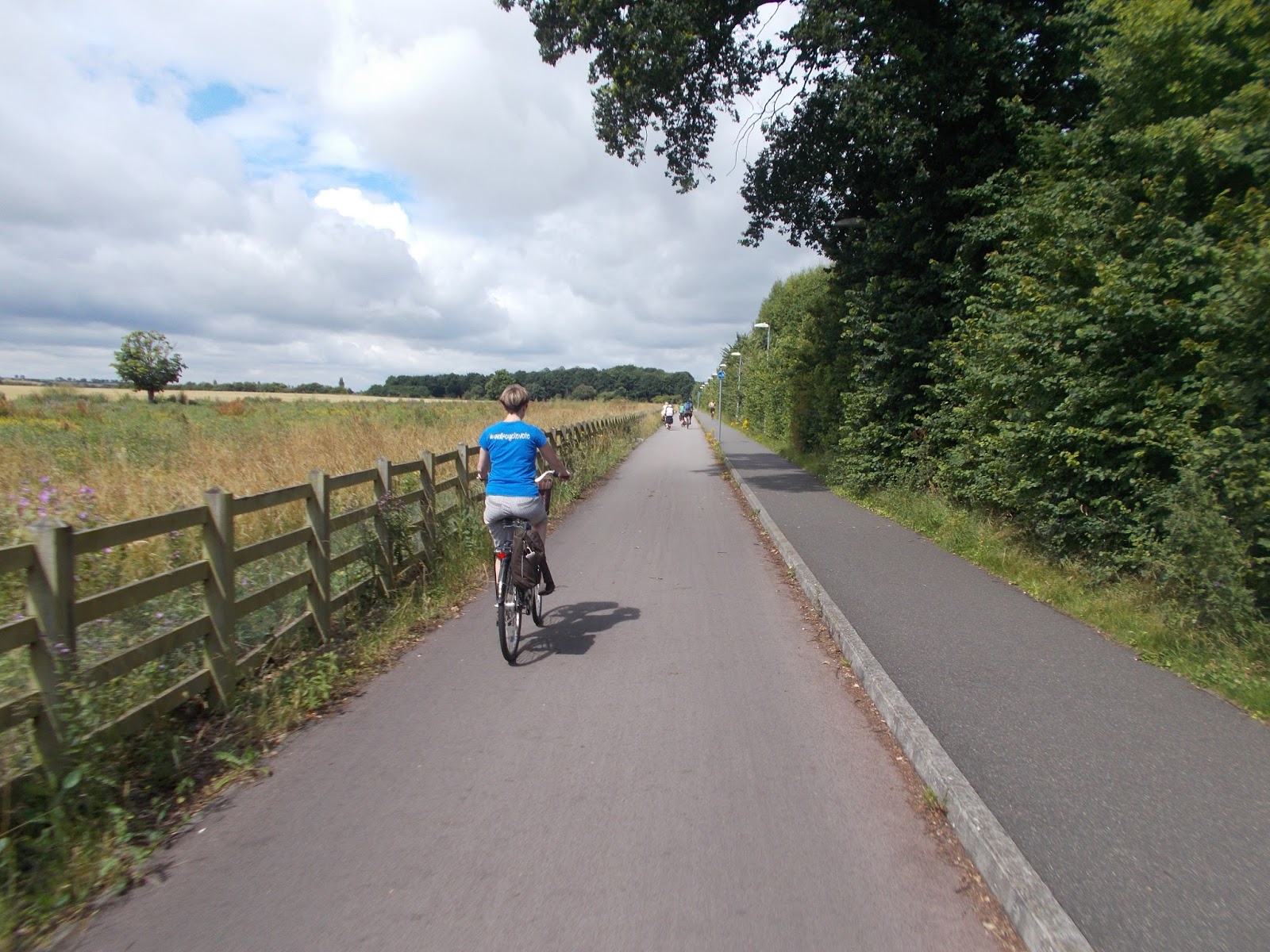
In fact, it's a cycle road and very good too. I suppose today, we'd use lower kerbs with a gentle profile. But, it is really good and one can easily eat the miles on a infrastructure like this! We turned off the Coton Path into a growing complex of buildings which are part of the University of Cambridge's development in the west of the city (because the centre is full up!)

Sadly, the infrastructure became progressively worse and this is a massive shame because it is all new build and as you will see, space wasn't an issue. First is a section of path after turning off the Coton Path. It's a shared-use segregated affair, but the paving is all the same with a contrasting centre line. You are cycling on block paving (left side I think) which is fine, but nowhere as good as machine-laid asphalt (photo below). They could have taken a cue from the Coton Path and built this with light block paving on the footway, a forgiving kerb and red asphalt for the track.


Futher west, it becomes completely shared (above). Then there are a series of estate roads and there is a shared path, segregated with a tree line. Again it's all block paved and people cycling essentially give way at each side road. It's a pretty version of what we can see all over the UK and it doesn't even have tactile paving to help visually-impaired people. 


The two photos above show that one cannot cycle between the tracks at junctions (at least without a detour). This is new build and should have been a world class demonstration of how to lay out streets for all. A huge shame indeed.


The little stuff
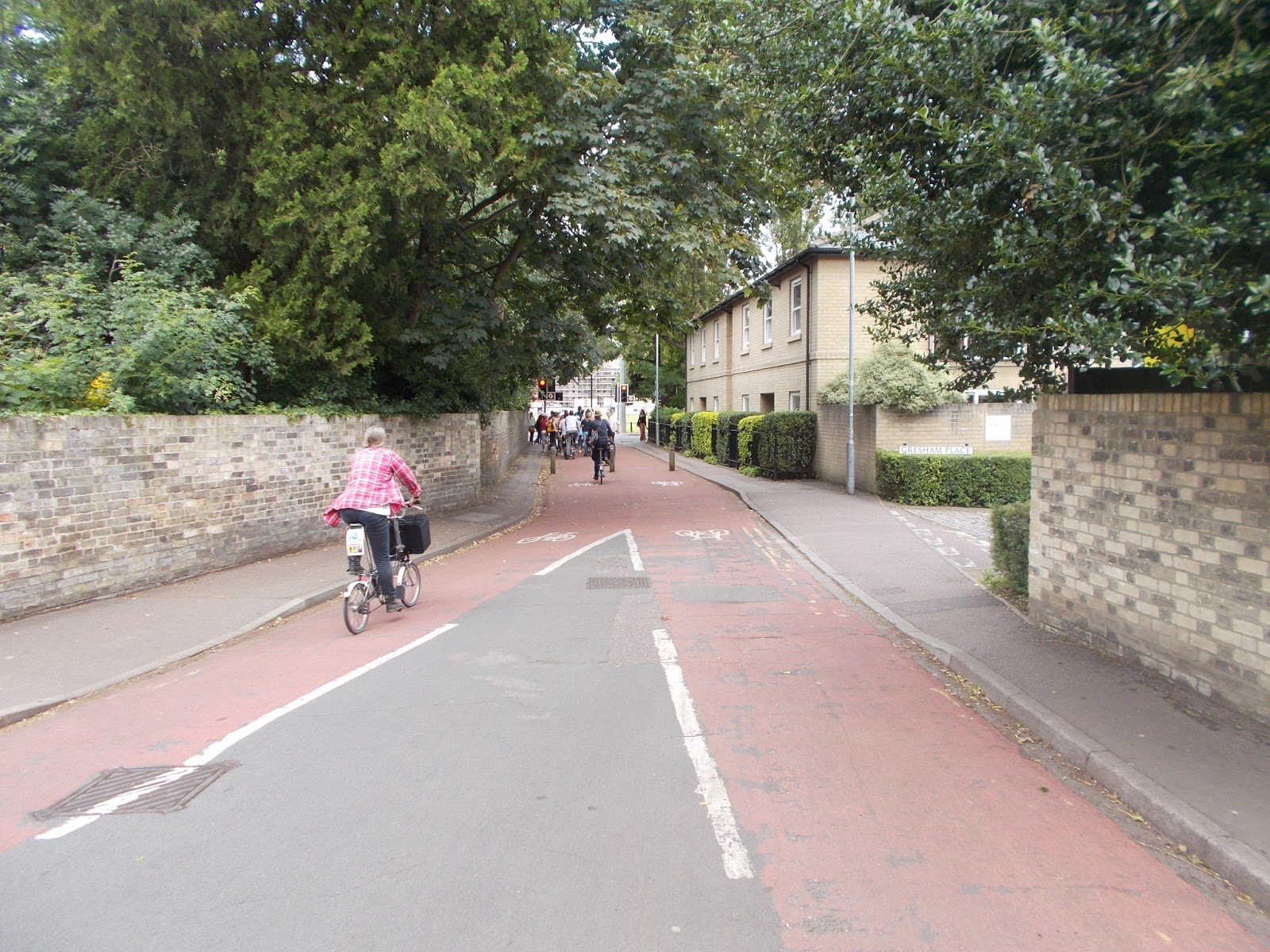
I want to round up this post with some positives. Regular readers will know that I am a fan of the little things which can have a big impact and in Cambridge, there is some excellent and pragmatic modal filtering to be seen. The photo below is the north end of Gresham Road which narrows down from a road to a cycle track using a simple row of bollards. The street ends in a parallel crossing of the A603.
 

 The crossing connects to the separate path and track shown below.


The photo below is of a filter at Gwydir Street. It needs to be modernised as although the slalom gates are OK to ride through, it's tight. We heard that the gates (for fire access) are rarely locked, but cheating by drivers is rare and it's locally policed by the residents!


This next photo is in one of the filtered areas either side of the Station and it not only shows contraflow one-ways for cycling (motors get access, cycles get through in all directions), but opportunities have been taken for greenery.


The photo below is (I think) St Philip's Road which is one way for motors and 2-way for cycles. It was built before we were able to have "no entry except cycles" signs and so there are narrow cycle bypasses which are too narrow for non-standard and adapted cycles; again, good principles which need updating to be accessible to all.


Conclusion
Cambridge is a nice city to stay in and a nice cycle to cycle around and I'd definitely recommend it if this was a travel blog! As an engineering blogger, I'd recommend it too as there is some really interesting stuff going on and certainly, there is some realisation that the private car simply doesn't fit in the city centre. This is not an ideological position, it's a space position. I hope that the practicality argument wins as this is a place where one should be able to get on with cycling for transport! 

Friday, 22 July 2016

The Flat Of The Land: The Cycling Embassy Of Great Britain's 2016 AGM (Part 1)

Last weekend saw a warm and sunny visit to the City of Cambridge for the Cycling Embassy of Great Britain's AGM. Naturally, the event included some cycling around looking at stuff and a big thank you must go to the Cambridge Cycling Campaign for being wonderful hosts.

I'll blog some thoughts over this week's and next week's post because there is a lot to cover. My health warning is that I saw the city on a weekend and of course weekday highway conditions are usually different.

I would love to have a quarter of what is going on in Cambridge in my area and so people throwing stones in glass houses would be a legitimate repost! You may also wish to read the view of a former Cambridge (and now Netherlands) resident, David Hembrow, on far wider issues than I will cover, but the high levels of cycling in the city is not wholly tied to the infrastructure, but to demographics. However, where stuff is built, people clearly want to use it!

So anyway; this week I will show some of the big interventions and big roads.

Bridges
Cambridge is pretty flat (don't write in!) and at least on the rides I went on, I barely changed gear. Where I did change was on the approaches to many of the bridges the city has to offer. For people walking and cycling, the city has the River Cam, railways and roads to contend with and so there are plenty of bridges, many built purely for active travel. The first one to mention wasn't on one of the tours, but I accidentally found it (and it was a shortcut for me). The Tony Carter Bridge connects south-east Cambridge to the city over the main railway and gives easy access to the station;


The bridge was opened in 1989, which probably explains the colour scheme, but is wonderful to ride over. The cycle track is red and stepped down slightly from the footway to give clear space and some work is underway on the western side to improve the ramp detail. The bridge is covered from the elements, although one would get wet when not on it! I wonder if the closed-in feel affect social safety at night?

A little more modern (2008) is the Riverside Bridge to the north of the city. It connects Chesterton with the city centre and there is some nice modal filtering, especially on the southern side by the river which provides a splendid approach to the bridge as you can see in the photographs below.


As one heads onto the bridge, one comes across a split with walking going left and cycling going right. It's a gimmick but a bit of fun too. The deck could have been a little wider and the parapet rails not bent in (reducing working width), but there was no silly zag-zags and it flows along the desire line.


It wasn't all wonderful bridge-wise, with the example above not really suitable for cycling, but don't let that put you off, it's great to see active travel bridges being provided on their own merits.


Main Roads
I'll cover side roads in next week's post, although they have long been used as cycling infrastructure in Cambridge. Main roads, on the other hand, haven't had much investment and so many are awful;


The photo above is of Hills Road (A1307) at its junction with Station Road branching off. I took the shot at about 9.45 on the Sunday morning when there was a steady stream of people cycling and few cars. It's 1970s engineering, designed for motor traffic throughput. The left turn into Station Road is left-hook territory and it is the same as we see up and down the UK. Cycling here is despite the conditions.

Further south, there is a substantial investment ongoing along Hills Road where former (narrowish) mandatory cycle lanes are being replaced with cycle tracks complete with floating bus stops. The photo below shows the assembled kerb nerds looking at the difference between the old and the new.


The tracks are 2.3m wide and are uni-directional (so one each side of the road running in the same direction as traffic). The tracks have taken a little more carriageway than the old lanes and are nibbling away at the old footways (some actually giving more pedestrian space as old shared-use segregated cycle tracks are coining out) and verges (without affecting pedestrians). The floating bus stops are welcome and vital for a modern layout; dare I say getting a little boring? (It's a good thing, it means we are seeing more around the UK!)


The bus stop islands have been arranged with the shelters opening towards the cycle track which keeps the views between people walking nice and clear and humped (but uncontrolled) pedestrian crossing points are provided roughly where the bus stops. Whereas the generally wide tracks allow side by side cycling (or single line cycling and overtaking), the track narrows to single line cycling presumably to slow things a bit to keep it safer for pedestrians.


The photo above shows the old shared/ segregated track which will be turned over fully to pedestrians soon. The verge area is actually a narrow strip of sedum matting which gives some separation between people walking and cycling (and provides space so people can use the whole track width. The red surfacing and double yellow lines give good visual priority on the track.


It all seems great so far, but I'm going to have to talk about kerbs and it's a criticism I'm afraid. Cambridgeshire County Council worked with supplier Aggregate Industries to come up with a gently ramped kerb which would give vertical separation, but be safe to cycle up and down. I heard about this a long time ago and thought it was being used for the kerb between the footway and cycle track (known as a "forgiving" kerb as it doesn't throw you off); in essence, a small step down from the footway to the track but using a gently ramped kerb. This is how they do it in the Netherlands and as it happens, in Leicester as I saw on last year's CEoGB AGM tour.

The "Cambridge" kerb has a slope of 22.5 degrees on its top surface giving a step of about 35mm. It is made from the same basic UK kerb dimensions and formed in a mould put through a hydraulic press. The different kerb profiles are created using formers placed in the basic mould. The manufacturer has developed profiles for some of the London cycle superhighway schemes and can competitively produce a run of about 500 metres.
 
For Hills Road, the kerb is for the cycle track/ carriageway interface which I thought was strange (and I still do). The official reason is as follows;

The raised cycleway option would allow emergency vehicles to pass more easily than the kerbed segregation option. This option would also be less visually intrusive than the kerbed segregated option.

I'm an armchair pundit on this I admit. I'm not the designer and I'm not party to the discussion and debate which led to this layout. A stepped track does provide more usable space compared to a kerb-protected track. Yes, it is less visually intrusive than a kerb-protected track, but we are talking about a busy A-road which carries lots of traffic which is presumably visually (aurally, nasally and pulmonary) intrusive and getting out of the way of ambulances near a large hospital is plausible. 

However, I look at it two ways. If motor traffic is not stuffed, then an emergency vehicle on blues-and-twos will get round. If motor traffic is stuffed, then speeds are slow enough for drivers to mount the kerb if they really have to and that assumes both directions are stuffed. Stepped tracks don't have to have a high kerb (although higher might give more protection) and so if we had a 60mm general upstand, dipping to 25mm at private accesses, the levels can be made to work and drivers could bump up if they really had to.

Because of the use of the forgiving kerb on the carriageway side of the tracks, I'd have to class them as giving "light" separation. I did cycled up and down them and barely noticed and on my way home from the weekend, I probed them in the car (not at a great speed and when there was nobody cycling near me I will add) and they were hard to detect.
I'll let you be the judge, but, on the flip side, I saw nothing by high compliance and the space felt comfortable to use, even near buses as the photo below shows.


I am not able to vouch for the junctions in detail, but the track dropped (35mm) to the carriageway at side roads. For private accesses, the Cambridge kerb was maintained which is absolutely fine to drive over to park up on one's driveway! As far as I could see, there are no plans for the big junctions just yet.

To the north of the city, a similar main road treatment is taking shape on Huntingdon Road (A1307) and this includes a parallel zebra crossing bu Oxford Road which I think is another road used as a key local cycling route as the crossing helps movements into and out of the side road.


The photos above show Oxford Road approaching Huntingdon Road, left onto a shared area/ adjacent track, the parallel zebra  crossing and the view back. Apparently, because traffic is often stuffed at peak times, people use the track and swing right into the crossing to then head the other way (essentially a right turn out of Oxford Road). There is a centre island in the crossing (about 3m wide), although it does mean some drivers might treat it as two crossings. My view is that it's a layout which doesn't immediately come across as intuitive to all road users.

One last main road to look at is Gilbert Road which (after a modal filter) leads north-east from Oxford Road onto a more residential street. The treatment here is red surfacing inlaid into the carriageway with advisory cycle lanes (common in the city). The centre line has been removed and the overall idea is that this reduces traffic speed and is more likely to keep drivers out of the lane.


Again, traffic was light and drivers tended to give us space. I'm not sure if that's because we were in a group or if its how people drive in the city; it was notable that driver behaviour was far better than my local area (yes, anecdata alert!)


Cambridge Guided Busway
The busway connects towns and villages around the city into the centre via the station. We had a look at the section south of the station because rather wonderfully, a very nice service road-cum cycle track has been provided next to it!


The busway itself has concrete "tracks" used to guide the buses in a kind of tram-like fashion. It's all nice, but the cycle track is the thing we were interested in. It's fairly wide, smooth and lit and so very usable (although it could perhaps feel lonely at some times of the day/ night I'd imagine). We took a spur to the Addenbrooke's Hospital complex which featured a rare climb overt the mainline railway. This is a route which can be walked, but really, it's a cycle route and was very good indeed. I think my only slight concern is the track is right next to the busway and some separation would have been welcome.


A 1970s Throwback
Cambridge has a ring road, although it is essentially a groups of roads acting as such and not a purpose-built road. On the north-west side of the city, the Ring Road (A1134) was an attempt to solve the problem of not having a proper continuous ring road with an elevated dual-carriageway (going over the River Cam). It's of 1970s heritage (give or take) and it shows. Cycling is relegated to a shared cycle track which is basically the concrete flagged-footway with some shared use signs.


To the south of the Cam, we have an excellent example of 20th Century anti-people distopia where people walking and cycling are expected to dive into narrow and intimidating subways which open up into a concrete open space. Well actually, Kevin couldn't get his recumbant tricycle down there which is a sod because it is his mobility. It's truly awful.


The sole benefit of this motor-nightmare is the bridge over the Cam gives wonderful views along Riverside which links to the Riverside Bridge which I referred to in the first secton.


Conclusion
Despite the high levels of cycling, Cambridge is a city trying to come to terms with the private car. On the one hand, there are large interventions to try and civilise main roads or provide good links away from busy roads. There is also the busway which aims to provide a quick run into the city

On the other hand, it is a growing city where people drive in and this in turn leads to a demand for parking and more roads; there are city centre car parks which raise revenue for the City Council which means reluctance to lose funds which I can understand.
 
Next week, I'm going to look at some of the smaller things we saw and some cycling infrastructure which is a little further out from the city.