Sunday, 26 January 2020

A Matter of Priorities

An interesting little quirk of UK cycle track design popped up this week and I thought it might be interesting to look a bit closer.

The subject is shared-use paths being given priority over motor traffic which was being discussed on Twitter earlier in the week in terms of making them as good as possible against the backdrop of a local authority refusing to look at separate walking and cycling space. Thanks to @24bitwarrior for the question and to @walking_boston for the link to an older piece of guidance from Sustrans.

Coincidentally, Adam Tranter tweeted a photo of exactly the thing we were talking about later in the week;


The location is here and if you have a look around the area, the treatment is unique, although it's at one end of a network of shared paths. It reminded me of a similar layout in Crowthorne which you can see here - there are others in the UK and it would be quite nice to compile a list, so feel free to tweet me locations.

The locations take a similar approach where you might have the shared-path (which strictly legally speaking is a cycle track which is shared with people walking) running next to or set back a bit from the carriageway and where it meets a side road, it is "bent out" from the main road as it crosses the side road. Bending out means that drivers can get off the main road before having to stop for cycle traffic.


As you can see from the diagram above, drivers would turn off the main road into an area at least 5 metres deep to give way a second time to cycle traffic. Apart from the design being used in New Town style estates, we know these are historic because the crossing is on a hump commensurate with the regulations at the time. Current regulations don't require a hump, but in the context we're talking about, I think humps remain useful to reinforce priority to cycle traffic and provide a level surface. We also often see red asphalt which lost favour in the UK (so did building cycle tracks of course).


Here's another clue. The photograph above is from "Cycle Friendly Infrastructure", a design guide from CIHT dating back to 1996. This actually has a separate footway, but the concept has been around for years and a study was undertaken by TRL in 2000 looking at this type of layout (with various configurations).

The TRL conclusions essentially fell back on the government's hierarchy of provision which is to make conditions suitable for cycling. 20 years on we know this doesn't work and if you need a cycle track, then surely the carriageway isn't suitable for cycling - this design has been used on distributor type roads which are awful for cycling. 

TRL more sensibly concluded that the traffic volumes in the side road should be low, perhaps under 100 vehicles per hour (which I am assuming is the two-way flow as it isn't clear). They also suggest that good visibility is required for people cycling to see and be seen (with commentary on main road flows) and that space is needed for the bend out layout.

The other issue is the layout of the junction looks like a traditional driver-oriented layout which invites motor traffic priority - the give way markings used in this way are going to be unfamiliar to many drivers.

I would also comment that the main road layout and volume will be an issue. A right turn pocket should be provided so that a right turning driver can pause before making the turn. This means they can see the side road layout and the need to give way to cycle traffic. Without a right turn pocket, people will have to find a gap in oncoming traffic and see the side road layout in one go.

A better approach altogether would be to have the side road as one-way out onto the main road which removes some of the conflict. With an estate, traffic signals can be used to manage conflict where 2-way traffic is required. The layout doesn't really seem to have considered people walking. We should be providing tactile paving which means on a shared-use path, people have to cycle over them which can be uncomfortable and slippery. 

I'm not entirely sure about the priority issue in terms of pedestrians either because strictly speaking, the give way road markings are about vehicle operators giving way to other vehicle operators, so people on foot might be in a grey area. We could in theory make the side road crossing a zebra, but for cycle traffic, we'd need to fudge in a parallel crossing.

Going back to the original question. I think it is going to be difficult to build shared-use paths with decent priority that people cycling can be confident with in terms of drivers giving way with these older layouts. I have less of an issue with shared-use paths in rural places where people walking are going to be a rarity, but in urban areas, they are poor for walking and cycling.

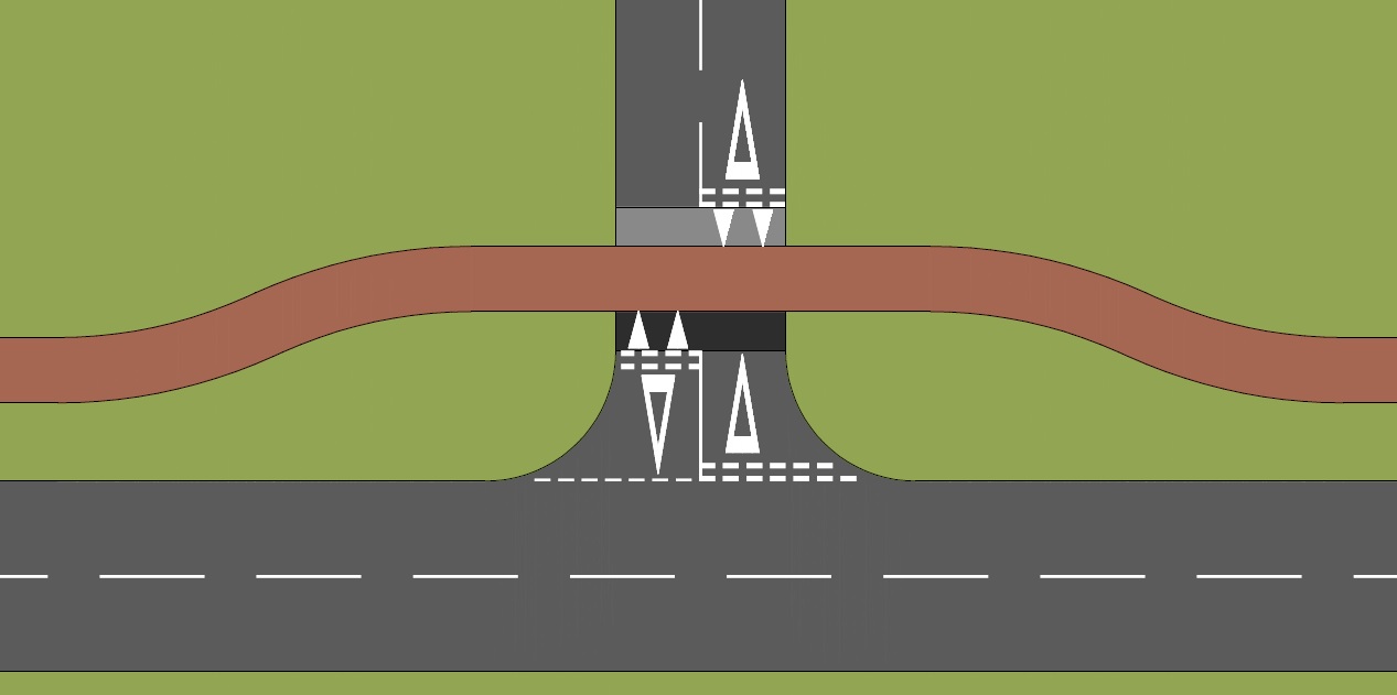
My thinking is we need to make the side road look like a side street, so we'll use our new entrance blocks at either end of the junction approach for a change in level with the carriageway width taken down to 4.8 metres to keep things nice and slow. The shared-use path should be a contrasting colour to the road (I like red) and perhaps flank it with some cobbles or setts to help with visual priority.

The area either side of the cycle track will be a contrasting material to the carriageway and shared-use path - perhaps grey block paviours would work. We can also introduce tactile paving, 800mm deep either side of the area which drivers traverse because visually impaired people need help - set them back a bit from the area being over-run by drivers to keep it looking less like a road.


The image above puts these items together, but clearly, a council which wants to put in shared paths won't want to spend money on junctions. They'll leave it like a traditional junction and people cycling will have to give way.

Sunday, 19 January 2020

Terrible Barrier

Yesterday, I combined an invitation to be a panelist at Camcycle's AGM with a bit of a mooch around Cambridge city centre and a mini infrastructure safari.

I'm hoping to be back for a proper infrastructure safari later this year and so this week, I'm going to concentrate on one thing and that's the new counter terrorism installation at Kings Parade in the historic heart of Cambridge.

It's a location which has been a concern from a counter terrorism point of view for some time. We've seen the incidents where vehicles have been driven into crowds of people and Kings Parade is a popular tourist spot for tourists taking photos of Kings College as well as enjoying the beauty of the street.

The problem is, Kings Parade is also one of the busiest streets in the city for cycle traffic and so one would have thought that this would be taken into account in designing the installation. Sadly, it seems that cycling and walking have been ignored.


The barrier has been installed here and is a familiar collection of oval (on plan) concrete-filled shell blocks (called "barges" by the manufacturer) combined with a central openable gate. The barges weight about 3 tonnes each. The installation is designed to stop someone driving a vehicle into a crowd - know as "hostile vehicle mitigation" (HVM). 

The system uses its mass and friction with the ground to prevent someone driving a vehicle through, although the units will be moved in the event of a high speed collision - the point is to dissipate energy and bring a vehicle to a halt, probably with extreme damage. The photo above shows a pair of barges either side of the gate (for occasional access I assume). The barges are connected and so there's a lot of mass there. There are two individually placed barges on each side of the gate assembly which are offset from each other but not connected. 

The street has a wide footway on the eastern side of the street and a narrower one on the west side; a fairly narrow carriageway and a loading bay (the cobbled are to the left of the carriageway in the photograph). The installation of the gate straddles the carriageway and the loading bay (which turns into a hard strip) with an area left for cycle traffic to the western side of the carriageway. The footway width on each side is maintained, albeit with two barges each.


The photograph above shows a closer view of the cycle side of the installation which has a pretty narrow gap between the barges - so narrow in fact that people have to cycle through in single file. That wouldn't be so bad, except it's a gap for two-way cycle traffic!


On close up, it's even worse. Almost half the space is a granite sett channel (with a slot drain in centre) and a kerb with a slight upstand. Granite can be very slippery to cycle over and the design means that every person who cycles through in damp or frosty conditions is at risk of falling off their cycle - right into the barges. While I was on site, I saw a few people cycling and one motorcyclist across the footway.

Two-way cycling is not possible and so people have to give way to each other. Although people cycling are very adept at adjusting their speed and direction, this pinch point slows progress and creates the potential for head on collisions - here's me cycling through;


I had a look at about 10.30 on a Saturday morning - imagine the chaos on a weekday peak - it really is so poorly thought out.

Just beyond the barrier to the south, there is a junction where Kings Parade turns into Trumpington Street with Bene't Street off to the east. Trumpington Street has motor traffic restrictions (signs) from the south from it's junction with Silver Street, but of course any would-be terrorist isn't bothered about traffic signs. In theory, therefore, someone could drive about 160m along Trumpington Street where there are plenty of people milling about.

The area to the north of the barrier is better protected. Kings Parade becomes Senate House Hill where there is a rising bollard which appears to be used to permit emergency access; there's probably more people milling around to the north of the barrier. 

The wider problem the city centre has from a counter terrorism point of view is that although there's a large pedestrian (and cycling) zone, there is an "except access" exemption and frankly anywhere could be a target. There will be analysis to demonstrate that Kings Parade is a site of concern, but it seems to me that a larger review is needed. As far as the current barriers go, they really need to be changed.

It's a wider issue for the UK. We keep rolling out this stuff in response to concerns about terrorism, but in the process we make day-to-day access for walking and cycling more awkward as well as helping to clutter our streets. In many ways, the terrorists have already won.

Saturday, 11 January 2020

So Near, So Far

I happened to be in Cambridge this week and I also happened to see some relatively new streets. You would think that in the UK city with the highest rate of cycling that I'd have seen some world class cycling infrastructure? Sadly not.

OK, what I did see in the Eddington development, in the northwest of the city was far better than literally most of the UK, there were some fundamental flaws with what had been built. I think most of the issues lie with the design rather than a lack of skills from the road workers who built it.

I don't know a lot about the development itself, but from what I have read, it aims to be a highly sustainable development and it certainly looks impressive, but as this is a highways and transport blog, it's the road details which interest me. 

The development sits between Madingley Road and Huntingdon Road with a new spine road connecting the two - Eddington Avenue. Towards the centre of the site, Eddington Avenue has a a bus gate which operates between 7am and 7pm. The bus gate is meant to be controlled by rising bollards, but it is currently staffed because of mechanical problems (the street network being currently under private developer control).

The bus gate is bypassed with Turing Way which immediately creates a potential issue of attracting through traffic. This may or may not prove to be an issue in the future as I don't know how attractive the route will be and in principle, a distributor road isn't necessarily an issue. In fact, the road layout largely provides protected and buffered space for walking and cycling.


As can be seen in the photograph above (at the north end of Eddington Avenue) there is a footway, a (one-way) cycle track and a verge buffer on each side of the street. Bus stops are floating and every so often there are communal underground refuse collection areas with laybys for refuse vehicles. Actually, it has a very Dutch feel to it. The cycle tracks are machine laid in red asphalt and the footways are finished in attract concrete block paving.

However, the disappointment for me is three-fold. First the central part of Eddington Avenue loses the cycle tracks and one is expected to mix with general traffic - the designers were trying to create a town square, but in transport terms it doesn't work for me. Despite the bus gate, there is quite a bit of on-street parking near a new primary school and some of the parking is echelon laid out to encourage drivers to reverse out which is a safety risk for cycling. 

There are connections through the The Ridge Way cycle route which are not defined through the town square which means people cycling have to pick their way through people walking and street furniture so it's less successful for walking too. I don't know who decided on the town square idea, but for it to have worked well, the connections to The Ridgeway should have been acknowledged, embraced and made legible for people walking and cycling. The area should have been car-free, and if not, the cycle tracks should have been carried through. Despite being an access to the primary school, parents really won't want to mix with traffic and buses.

Second, the provision for walking and cycling at each end of the development where it connects to the existing road network is poor. The signalised junction with Huntingdon Road doesn't even have a pedestrian crossing over Huntingdon Road and people cycling are mixing with traffic within the junction, although the paint gives way to protected cycle tracks along Eddington Avenue. There is a toucan crossing over the entrance to Eddington Avenue, but it is two-stage and staggered, the latter being less helpful to the users of non-standard and adapted cycles;


The photograph above shows how people cycling north towards Huntingdon Road are treated - they are essentially dropped into a central advisory cycle lane which ends at an advanced stop line. Also known as a "murderstrip" by the Belgians. It is not a layout which is safe for all and so people jump onto the footways and in fact, there are blue shared-use signs after one is dumped in the road, expect there's no way onto the footway from the road. At the Madingley Road end, it's a little better with toucans crossings all round, but again, we have two-stage staggered arrangements.

The layout of the two connections will have been heavily influenced by Cambridgeshire County Council which has prioritised motor traffic capacity over active travel. Huntingdon Road and Madingley Road are both A-roads providing connections into Cambridge City Centre. Despite the Madingley Road end of Eddington Avenue serving a large park which should take out traffic going into the city, the decision has been taken to maintain traffic capacity.

I can't lay this totally at the County, they are responding to how the UK transport planning is arranged. If a development creates traffic congestion, then there are grounds to refuse planning consent. Therefore, everyone involved works hard to ensure a scheme is (as far as possible) motor traffic neutral and walking and cycling usually suffers. This can be traced back through planning and transport legislation which makes it hard for a planning authority and its councillors form acting differently. 

What we should be doing is setting objectives which prioritise walking, cycling and public transport and giving what's left to the private car. In this location, this would have meant single-stage crossings with walking and cycling have their own separate and protected space.

My third disappointment is the detailing on Eddington Avenue and Turing Way. This is a new build and it should have been world class, but it doesn't even conform to designs which we managed to build several years ago.


The photograph above captures the issues. The footway and cycle track are at the same level and so the practice has been to provide tactile paving and a raised demarcation kerb between the two. On the walking side, the tactile paving has ridges running across the line of travel (known as ladder paving) and on the cycle side, the tactile paving has ridges running along the line of travel (tram paving). This arrangement is to help visually impaired people find the right side to walk.

The paving is present, but it is inconsistently applied and the central demarcation block is missing - a basic edging kerb has been used. The lack of raised demarcation makes it harder for visually impaired people to know where the edge of the footway is. Had it been provided, it would have looked like this;


Had the cycle tracks been stepped (i.e. at a lower level than the footway) then we could have dispensed with pretty much all of the tram and ladder paving and given better information to visually impaired people such as this example which shows a higher kerb where people might walk towards the cycle track perpendicularly and a lower (and forgiving kerb) along the line of travel. Given the scale of the site, the developer could have had 30° splay kerbs developed!


The other problem comes at junctions and accesses. The modern principle is to make footways and cycle tracks continuous over low traffic junctions and accesses to prioritise walking and cycling. The photograph below is a service access to the primary school which I am assuming is very seldom used.


We have tram and ladder paving to ensure visually impaired people are on the correct side and the footway ends with blister paving to show a crossing point. Kerbs from the edge of the carriageway continue into the access along with double yellow lines - cues to the driver that they have priority. The immediate junction with the main road also looks like, well a junction. People walking and cycling see "their" paving carried through the access which gives an impression that they might have priority. The problem here is, that in the event that everyone thinks they have priority, then it's those walking and cycling who come off worse.

At a seldom used access, this is probably not a significant safety risk, but at the junction of Eddington Avenue and Turing Way is most definitely is;


The paving colour is taken through the junction again, although now we have blister paving on the footway and cycle track. For cycling, the movement is one-way into the distance and so there is a risk of being hit from a driver turning left. The cycle track is not set very far into the side road (Eddington Avenue) and so someone cycling would have to check over their right shoulder that it's safe to cross. The dropped kerbs are not flush either (although that is a construction issue). 


There are a number of crossing points over the spine road (which is a good thing). The photograph above is typical with a tactile deluge. The correct detail here would be to keep the cycle track and the footway running through with a localised crossing of the cycle track to the "floating" waiting area to cross the main road. 

The other frustration is for people wanting to cross the road by cycle. The photograph above has a side road coming from the right. If one was cycling and wanted to turn right, one would expect access to the cycle track on the left hand side of the photograph. But one cannot because there is no gap in the verge. Conversely one cannot turn right from the cycle track into the side street opposite.

There are some great details. The verges are actually part of the surface water management system, give space for trees and create a safety buffer. There are on-street parking bays which have a buffer from the cycle track to stop dooring incidents. Where space is a little more constrained, the cycle tracks are next to the carriageway, but a wide kerb has been used to help provide a buffer and a visual break. The town square looks rather Scandinavian (if you ignore the parking and lack of clear cycling space).

It's now probably too late to go back and retrofit the site to my exacting idea of utopia. Demarcation blocks are 200mm wide and the work to remove the edging kerbs and their foundations to put in demarcation blocks would be substantial. Reworking the quiet junctions and access should be easier (but still costly), but now we have entrance kerbs in the UK, we could do something like this;


Where the side streets meet the main road, we could add cycling access to the cycle track opposite and tidy up the pedestrian crossing points like this;


The greatest challenge will be to sort out the junction of Eddington Avenue and Turing Way (remembering there are two junctions). I would like to see the crossing points set back into Eddington Avenue at least 5 or 6 metres and a design taken on priority. Because buses are turning into the side street, the entrance kerb treatment would work because bus traffic will damage the kerbs and paving.

I would like to set the crossings point back into the side street about 5 or 6 metres. Then a decision is needed in terms of priority. The layout should either make it clear that traffic has priority like this;


Or we can continue the walking and cycling priority with a parallel zebra crossing like this;


If the crossing point cannot be set back, it is harder to decide, but given it's Cambridge where cycling is being gradually improved I would look at the parallel crossing option and seeing if the junction could be made any tighter for turning traffic. Luckily, it's not my decision and I'm not advising!

So there we have it, a good try to be sure. But, the scheme is let down by the lack of attention to detail which is a shame because as is often the case, doing things correctly doesn't cost any more than doing them badly.

Saturday, 4 January 2020

Out Of Alignment

I think I have got a pretty good handle on the rules, regulations, guidance and practices of how street elements fit together, so even if I don't realise it at first, things gnaw away at the back of my mind.

Zebra crossings are one such element which I notice things wrong with all too often, but how about this example I found near Kings Cross Station in Central London;


It's actually part of a set of three zebra crossings which all land on a triangular pedestrian refuge island within a wider gyratory - here's a better view from Google with the crossing in the photograph above being the one on the left hand side of the view below;


There's quite a lot "wrong" with the layout such as grey tactile paving being used when red is the standard colour for "controlled" crossings (signals and zebras), the tactile paving not properly lining up across the crossings and poor lighting of the crossing points as well as poor local drainage and maintenance issues.

The use of zebras within a layout such as this does at least accommodate pedestrian desire lines and so I've no in principle objection, although being a gyratory there is certainly a high risk of drivers speeding off peak.

However, the thing which gnawed at me was the layout of the stripes. It was only when I used to crossing for the third time in a few weeks that I noticed it. In the UK, zebra crossing stripes are rectangular in shape and are arranged in the direction of travel. The regulations governing the layout require the stripes closest to the kerb to be black (or the carriageway colour if there's enough contrast with the white stripes).

The figure below shows what has been installed (left) and what should have been installed (right);


The rules are quite flexible in terms of the layout because every situation might need particular layout requirements, but having the stripes rectangular is a fixed required. Section 16 of Chapter 6 of the Traffic Signs Manual gives full details.

But does this mistake matter in reality? From a legislative point of view, one can argue that the crossing is not lawful and the implication is that the rule of carriageway users having to stop for a pedestrian on the crossing won't apply but how many drivers approaching this installation would think that - judging by the behaviour of some people, the requirement to stop is routinely ignored.

As ever, this kind of thing would need testing in court either as the result of a collision or through a claim or other civil procedure. On balance, I would say that if it looks like a zebra crossing then it is and a court would probably consider a bit of variation on stripe arrangement as de minimis in the same way as a failed Belisha beacon would be. However, rules are put into place for consistency and so this stuff should be right and I would extend that to zebra crossings used on private land and car parks on which there is case law.

Other countries don't necessarily worry about having the stripes aligned in this way, preferring to mark in the way my non-conforming example has been marked. Here's an example from Maastricht in the Netherlands, although stripes are used at signalised crossings too;


Or how about this Swedish version from Malmö where the stripes are rectangular, but offset as they go across the road!