Saturday, 27 August 2022

Summer CYCLOPS Safaris: Part 2 - Cambridge

In my last post, I had a look at the first and third CYCLOPS junctions built in the UK in Manchester. In this post, I head 200km southeast to look at the UK's fourth, in the City of Cambridge.

This scheme at the junction of the B1049 Histon Road with Gilbert Road and Warwick Road was opened in October 2021 just over a year after the first one in Manchester. It came to fruition thanks to the efforts of the local cycling campaign, CamCycle, which had been pushing Cambridgeshire County Council to go with the design after seeing the original Manchester plans and is part of the Histon Road transport scheme.

A CYCLOPS junction which is a crossroads with a pedestrian crossing island on each of the four corners with an orbital red cycle track running behind them. There are crossings from the footway over the cycle track onto the crossing islands with mini-zebra crossings.

The layout of the junction is simpler and tidier than the Manchester examples because the designers have eschewed the plethora of fiddly islands in favour of corner islands which have pedestrian space set at footway level (above), together with splitter islands for each approach and exit between the carriageway and cycle track (so a total of eight). The footway level corner island means the push buttons for the pedestrian crossings are much easier for wheelchair and mobility scooter users to reach than the Manchester version which sit on islands.

A view towards the junction showing a red cycle lane splitting into two. To the left, the cucle lane peels left behind a pedestrian crossing island. The the right, the cycle lane ends at an advanced stop line for cycle traffic.

Each approach has an Advanced Stop Line (ASL) and for the Histon Road arms, access to the ASL is from a cycle lane. For the northbound direction, a section of stepped cycle track ends and becomes a cycle lane and for the southbound direction (above) this is from a mandatory cycle lane which runs for a significant distance approching the junction and so does offer as much protection. 

The layout is tidy and for those going ahead who see the advantage, reintroduction to traffic is simple, but it does of course put people cycling at left hook risk and if one were turning right, then the CYCLOPS provides a safer option. This "hybrid" approach using ASLs is a symptom of traffic flow being maintained as with the first Manchester example.

A closer view of a red advanced stop line area.

The ASLs on the side roads are fed by advisory cycle lanes and so are the exits. If we ignore the ASLs for a second, these advisory cycle lanes feed into (above) and exit from the junction (below) on the side roads and with the positioning of the splitter islands (in a nice contrasting colour), people cycling have a protected entry to and exit from the junction. This is a really important safety feature and with junctions being the collision risk, investing there with simpler link protection is a pragmatic approach and can be upgraded later,

A red cycle track with grass to the left and a traffic island to the right. The cycle track peels left and ends at a carriageway which heads off left.

The pedestrian arrangements for the junction are very clear. There are mini-zebra crossings onto the corner islands which I prefer and there is a very shallow hump to give a more level crossing experience (below). For some reason, the designers have marked the humps as if it were a two-way cycle track which seems to be a mistake. It's not vital, but I would have quite liked to have seen the corner islands surfaced in the same light colour blocks as the splitter islands to break up the asphalt and to provide some contrast to the carriageway, but it's not vital to the design.

A close up of a mini-zebra crossing over a red cycle track. A child is on a crossing island to the right pressing a crossing push button. A man carrying a child's scooter follows. Behind the man on the mini-zebra crossing, a small child scoots.

One thing which is an issues is the use of tactile paving. Mini-zebra crossings require the use of red tactile paving (almost always) whereas buff is reserved for non-controlled situations. At Histon Road, the designers have used buff with the mini-zebras which is incorrect. They have used red with the signalised crossings which is correct, but the use of the 'L' shaped layout could give the impression that this is the complete crossing.

A diagram of half a CYCLOPS junction showing grey footways and red cycle tracks. The mini-zebra crossings from the footways to the two of the crossing islands is shown. L shaped tactile paving in dark red is shown on the outer edges of the junction with rectangular tactile paving within.

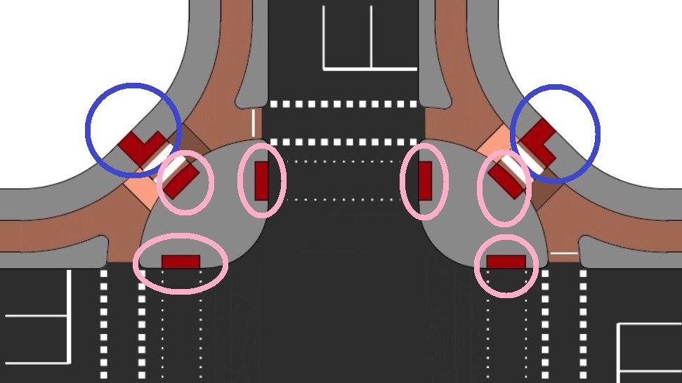
The guidance explains that we should be providing red tactiles at controlled crossings (zebras and signals). It says we should provide the 'L' shaped arrangements at the start/ end of complete crossings (circled blue in the sketch above) and where islands are part of the overall crossing, then the intermediate tactile paving is rectangular (circled pink above). This is important as it is all design to provide information to visually impaired users and I cannot understand why we keep getting this wrong.

A red cycle track with a pair of mini traffic signals either side of a stop line for cycle traffic.

As with Manchester's layout, low level cycle signals have been used in pairs - I would like to see a large signal to be viewable approaching the junction. The cycle demand is from a push button and I am not sure if any other detection is being used because I either pressed the button or others were using the junction.

A view of a red cycle track with a mini zebra crossing between the footway and a crossing island, a man is cycling on the cycle track followed by a small child on a cycle.

I do prefer Cambridgeshire's layout compared with Manchester's, because the island detailing is simply tidier. I also prefer the red surfacing which consistently applied across Cambridge because as well as being a warmer colour than the green of Manchester, it is also inlaid by machine for a superior finish. I also like the cycle crossings surfaced in the same material as it helps explain the orbital nature to users (above).

A woman is cycling on a red cycle track and is turning left just before a mini-zebra crossing between a footway and a crossing island.

There are other nice touches. The designers have kep the kerb heights a little lower than those in Manchester so there is far less risk of catching one's pedals or wheels on them, and the Cambridge scheme has slightly wider cycle space which makes all the difference.

In the final analysis, it's great to see places copying each other, tweaking the design, and delivering safer junctions. As I said in my last post, the official guidance doesn't go into the nuts and bolts detail of this type of junction and so being able to visit schemes is going to help designers going forward. Aside from the tactile paving mistakes and the ASLs, I'd say that so far, Cambridge is the design I would probably copy because it is so much tidier in layout.

There are dozens of these junctions being planned and built in Greater Manchester, a second is under construction in Cambridge at Milton Road and they are appearing in plans all over the country, including several I have helped with the design of in my day job. It's funny really, because despite Waltham Forest bringing the Dutch approach to the UK where cycles are the inside of pedestrians (the "innie" design), it seems the CYCLOPS approach is the one we'll see most with its "outie" design. It seems that having something named allows people to conceptualise what something is, even if they don't understand the details, and because this is all aimed at the user, it's fine by me. I'll leave you with a video of the Histon Road CYCLOPS.


Monday, 15 August 2022

Summer CYCLOPS Safaris: Part 1 - Manchester

At long last, I have manged to get out to go and experience the CYCLOPS junctions which are starting to be rolled out across the UK.

I have covered the Cycle Optimised Protected Signals junction designs before with a comparison with the Dutch approach and I have seen plenty of photographs and videos of the design. However, there's nothing like seeing infrastructure in the flesh and so in this post, I will have a look at the first and third examples of the arrangement which were built in Manchester.

A crossroads junction with grey footways, red cycleways and then a black carriageway. There is a pedestrian island at each corner of the junction with a mini-zebra crossing over the cycle track to get to the corner islands. The cycle crossings of the side roads are outside of the pedestrian crossings.


First, let's have a little recap. The sketch above is a general arrangement of the CYCLOPS junction. The red shows a series of cycle tracks and in this case, they are all with flow. This means that cycle traffic circulates around the junction in a clockwise fashion. The light grey is footway and island areas and the dark grey is the carriageway. You'll notice the mini-zebra crossings over the cycle track which in this case are placed on small speed humps and the dark red is tactile paving. 

The 'L' shaped tactile paving essentially shows the start and end point of a complete crossing of the junction and personally, I prefer this to leaving the cycle track crossings uncontrolled. The little speed humps are not about slowing cycle traffic, they are more around giving a level crossing point. Some visually impaired users do prefer having dropped kerbs as the slopes help show they are entering a crossing area.

In terms of guidance, Local Transport Note 1/20 "Cycle Infrastructure Design" uses a catch-all term of Circulating Cycle Stage Junction in S10.6.21 for signalised junctions where walking and cycling run together orbitally around an entire junction of which CYCLOPS is a style. It is possible to use two-way cycle tracks with the design, but I'll cover that another time.

Probably down to timing of publication, but LTN1/20 doesn't include a CYCLOPS junction, and the section on circulating stage junctions is very brief for what, in my view, is going to become a very important design tool in the coming years - as an aside, LTN1/20 doesn't go into enough detail on design generally, but that's another post. Here's a more detailed technical document explaining the concept.

A CYCLOPS junction with a cyclist crossing one of the side roads on a green cycle track.

The first CYCLOPS junction was delivered in 2020 on the Manchester to Chorlton Cycleway at the junction of the A5067 Chorlton Road and Royce Road (above). In the photograph above you can see one of four pedestrian islands on the left (one at each corner) with the pedestrian crossing in red. On the right of that, there is a the one-way cycle crossing (green) running in parallel.

A CYCLOPS junction with a pedestrian island shown prominently with various islands, kerbs, coloured surfacing and road markings.

Above is a slightly different view of the junction, this time showing more of the corner island and the traffic signals. Transport for Greater Manchester has elected to use a pair of low level cycle signals - personally I like to see a full-sized signal plus a low level sign with the former being more easily seen from a distance back. There is a push button, but that's a back-up because there is detection and it's too close to the stop line for my liking (coming at it from a non-standard cycle user's perspective. It is nice to see the button light up to show you are detected.

Another view of a CYCLOPS pedestrian island.

For pedestrians, there is no priority onto/ off from the island and I personally would have preferred a mini-zebra crossing. The island is quite complicated as it is really three small islands forming a larger space which sits at carriageway level and the further island (in the middle of the three in the photograph above) helps to keep left turning drivers out wide. 

The islands provide a vertical upstand to help cane-users to navigate, but they create a problem for wheelchair and mobility scooter users who cannot get close to the push button. A better approach would have been to place the posts at the same level as the walking surface. 

Because the access to the island is not in line with the signalised crossing of the road, people have to turn through 45° to move between the crossing points. This means that it is less likely that visually impaired people will mistake the crossings as single movement as can be the concern with in-line crossings. This is something DfT worries about in LTN1/20 (10.6.22) where mini-zebras are used with signals over the road, although I think this is overstated to some extent. However, it address some issues, so I am not against it.

Two cyclists crossing a side road. One on the CYCLOPS cycle track and one on the road.

The other design decision was to provide a gap in the approaching cycle track protection to allow cycle traffic to move out of the cycle track into general traffic, complete with an advanced stop line (ASL). This means that some cyclists may elect to move into traffic if the signals are showing in favour if that movement. The photograph above shows someone who has chosen to do this. 

This was the first CYCLOPS and so there was concern that people cycling wouldn't want to wait for a green signal, so the access to the ASL was an adjustment to counter the problem. The real problem of course is how much time we give to general traffic verus how nimble and efficient cycling is given that the CYCLOPS junction is motoring infrastructure. The signals engineers have been tweaking the detection and so it isn't a huge issue and in theory, the all round green for walking and cycling could be run twice per cycle.

225 metres south of the first CYCLOPS, we have the UK's third, which is part of the same scheme, this time at the junction of Chortlon Road with the A5067 Stretford Road

A corner island with a diagnal crossing point surfaced in red.

In many ways, it's the same layout as the first, but an immediate difference is the addition of a diagonal pedestrian crossing between the southeast and northeast islands (above). The junction is skewed which means one of the diagonals is quite short and because walking and cycling run under a single green, the diagonal is easy to accommodate. In fact, had the junction been designed in the Dutch way with the cycles on the inside, then the diagonal wouldn't have been possible.

A wider view of the crossing and orbital cycle tracks.

The walking layout on the diagonal islands is a little more complicated with two crossings of the cycle tack each, but as things are offset as with the first scheme, it all works very intuitively. There are no ASLs on this scheme, but there are gaps in the kerb protection if one feels the need to move out. When I cycled the two junctions I didn't have to wait too long and as you'll see in the video below, a complete U-turn is easily possible within the green which is a very important feature to allow people to change direction if they didn't want to cross the road to turn right at a proceeding junction.

The CYCLOPS junction is interesting because on the face of it, we get fully protected intersections which feels very familiar to anyone who has used such in other places, especially northern europe. However, at the same time, they are very much British and have a look and feel that will be familiar to politicians and designers (including signals engineers) as well as the public and that is why we'll see them all of the UK in the coming months and years.

Overall, I think the cycle tracks are a touch narrow, there are perhaps too many fiddly kerbs and islands, and the colour scheme is a bit garish, but the junctions work well and most importantly, they give a great sense of protected and action protection from traffic.

I'll leave you with a video of a bit of cycling in the general area, including these two new junctions.