Monday, 31 August 2015

To Bypass Or Not To Bypass - What Is The Answer?

Last week saw a lot of miles covered, with the first part of the week being a dash to Deventer in the Netherlands and the second part being back in Blighty (which is derived from Urdu if you're interested!)

The UK trip was mainly to see family, although there was a chance for an evening climb of Glastonbury Tor, as well as a day spent at the wonderful Stock Gaylard Oak Fair in Dorset (which I wholeheartedly recommend). But this is about transport, not days out. Driving down to the Southwest from London, we inevitably ended up on the A303 (which always has us think about the Kula Shaker song). The A303 is much nicer route than the motorways, at least until it goes to a single lane road at Countess Services where it is pretty much guaranteed to grind to a halt during peak holiday time. Dorset and a much wider area is bounded by the M3, M4 and M5 and with no motorways within, relies on the A-road network taking the strain.

Approaching Stonehenge on Salisbury Plain, my mind was cast back to the debate about what to do with the A303 as it passes the UNESCO World Heritage site and indeed some of the villages (which is in many ways a more important issue). The monument used to have a road on each side, but one road (the A344) has recently been removed along with a revamp of the visitor facilities (see Google Streetview from 2011 and 2015. 

It's amazing that we can make radical changes like this when we want to for a pile of old rocks (I'm being flippant). The A303 is still awful, but the loss of the A344 makes it a bit less awful and the junction with the A303 had a high casualty-rate. Mind you, with people slowing to walking pace on the A303 to take photos, it's no wonder that there are still crashes. Not everyone is happy, the Stonehenge Traffic Action Group (STAG) has claimed that the closure has pushed more traffic into local villages which would have used the A344.

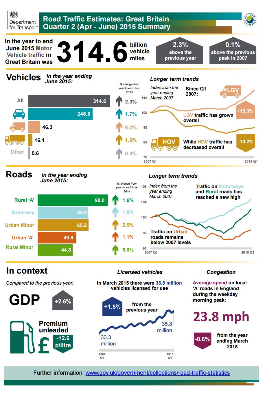
Winterbourne Stoke lies to the southwest of Stonehenge and is split by the A303. It contains a plethora of traffic signs and road markings attempting to slow drivers as they pass, although the speed limit is 40mph. There have been countless crashes and many fatalities on the A303 through the village in recent years and so not surprisingly, there is a sister campaign group to STAG, the Winterbourne Stoke Bypass Angst (WiSBAng) campaign. This section of the A303 carried just over 12,000 vehicles per day in 2000, rising to nearly 20,600 in 2014; although there has been some fluctuation over the years. 2002 saw 21,300 vehicles per day. An interesting comparison can be had with the Victoria Embankment in London which carried nearly 20,000 vehicles per day in 2000 and nearly 29,000 in 2014 (peak of over 42,000 in 2007).

It seems that there are friends in high places as work to the A303 has featured in the Government's road building plans, although the announcement was made in the last parliament. For Stonehenge, there are options involving tunnelling which would allow the landscape around the monument to be restored to an open setting, although the cheaper options mean major road-building within the World Heritage setting and groups such as the Campaign for Rural England are concerned about this and the wider road-building agenda. Mind you, the scheme has been on and off the roads agenda over the years - the Campaign for Better Transport celebrated its shelving in 2007.

Useful guardrail this, there is a drop down to the road!
So, to Glastonbury, which was a stopover for our trip and so there was just enough time between dinner and bedtime for a walk up the Tor

We walked along Chilkwell Street which is on the A361, before turning off to get to the Tor. The road passes to the south of Glastonbury, but new development has spilled over to the south and so the road splits the area in two. As we were walking back after our climb, I noticed posters in many of the windows in support of the "Lighten the Load" campaign to get freight traffic routed away from the town. The A361 doesn't have a high casualty rate (at least compared to the A303), but if our snapshot walk is anything to go by, I could certainly understand why people want change,

Awful photo of a 40 tonne lorry!
The reason why was soon brought home when two 40 tonne lorries went by, neither of which kept to "their" side of the road because of its narrowness. The photo to the left is on a raised walkway where the lorries didn't bother us (but the footway on the other is a different matter), but before we got here, the footway was so narrow that my group stopped and backed against a wall to let a lorry pass. Pretty scary for adults, let alone the kids.

Interestingly, the Lighten the Load campaign is pragmatic about the possibility of a bypass. There has been lots of talk over many years, but for the Southwest, Glastonbury doesn't appear as a priority. The campaign wants a 7.5 tonne weight limit to stop long-distance freight traffic passing through, although because the route is meant to be freight, the campaign worries that it won't be looked at. I don't know where this HGV traffic is going to or coming from, but a weight limit would need to be strategically placed and other places may be impacted. According to DfT data, the A361 carried 6,500 vehicles per day in 2000, which rose to 8,150 in 2014. HGV traffic varies over the time, but is about 6.5% now. LGV traffic (3.5 tonnes to 7.5 tonnes) is around 15%.

I tweeted the photos from Glastonbury which prompted opinions to the effect of tough, the people chose to live there and do they not shop in places which are serviced by these trucks? Now, it is a point I understand, but equally, why shouldn't people wish to improve their local environment? Our reliance on commodities shipped across the world and then delivered by the largest vehicles possible has crept up on us, along with the de-facto replacement of rail and passenger freight with motorways and trunk roads. I would not even think about doing the trip we did by train as it was done on a single tank of petrol (yes, the cost of running a car is more than that). 

Of course, despite having 6 of us in the car, we still added to the traffic jams, pollution and road danger. I am no fan of road-building, but I am struggling to find answers to Stonehenge and Glastonbury which don't involve road building. Perhaps my problem is that I am thinking about the places in isolation when I should be thinking about the road network on a county or regional level. The problem is the M3 ends up (ish) at Southampton with the M5 at Exeter; and as I have stated, Dorset and the wider area doesn't have motorways, although as a tourist, I can't say traffic jams are ever a major problem (but I don't live there).

If the traffic flow could be cut in half through Winterbourne Stoke, it would still be awful for the village. For Stonehenge, we could further ruin the landscape with a bund to stop the rubber necking. Perhaps a bypass of the area is the right answer. Perhaps rebuilding branch lines to these places and low rail fares will get tourists off the road network. Perhaps, tourists should stay at home, I just don't know. Tunnels are very expensive, but Stonehenge is an asset for the World and so is doing nothing really an option? I can imagine a tunnel, but with a cycle route left along the A303 so people can more gently stop and wonder at the monument.


For Glastonbury, is it right that long distance freight traffic passes so close to homes and the toes of cowering pedestrians, or is it tough? The country needs to function and freight needs to be assisted to keep the price of things down, especially with global competition.

The answers here are going to be beyond transport and into what society wants. The day at the Oak Fair showcased all sorts of products and produce from the local area. An oak picnic table caught our eye and we asked the chap on the stall where the timber came from. His answer was within three miles of the showground. This must be a clue to at least part of the answer. What do you think?

Wednesday, 26 August 2015

Deventer Dash

So this week, I found myself in the city of Deventer which is to the east of the Netherlands. It was a last-minute trip which involved lots of travelling, but it still gave me a little time to experience a pretty ordinary place by local standards, but I like to celebrate the ordinary.

I took a total of 7 NS trains in 2 days, including lots of time on these
heavyweight intercity trains. I became quite fond of them!
This post comes with a health warning; my visit was short and the things I saw were only snapshots; so I cannot possibly detail their intricacies or whether they are good examples or not. Please take this on board and note that I call it as I saw it. Also, please correct me using the comments, I am sure there are things I have got wrong.

My 560 mile (900km) round trip took advantage of the "rail-sail" ticket which gives train travel from anywhere within the Greater Anglia area to any NS (national) train station in the Netherlands via the Stena Line's very civilised Harwich to Hook of Holland ferry. I imagine the rail deal is available because Greater Anglia is run by Abellio which is owned by Dutch National Railways! If you can book a while in advance, it is pretty good value too. But, this is not *that* kind of travel blog!

Part of what is a bit like a ring road to the southwest of the core, but
probably just a main local road. Traffic lanes about 3m, cycle tracks
about 2.4m, with footways about the same. Stepped cycle track and
kerbs on footway side about 25mm upstand.
Deventer is municipality as well as a city and covers an area roughly comparable to the London Borough of Bromley. I only spent time in the city core which is about 1km by 1km. It is bounded by the River IJssl and some other bodies of water, with a kind of ring road, but not one with multi-traffic lanes everywhere, perhaps akin to a UK strategic road in Outer-London (i.e. not a trunk road).

A general observation was the main roads outside of the core had cycle tracks by or away from the roads and through signalised junctions. The protection fizzled out as one went into the core, turning into advisory lanes and then no provision at all. I didn't see it, but there is also a notoriously dangerous roundabout in the city too (thanks David Hembrow) - Dutch is not always good being the lesson here.

It did seem rather old from a cycling point of view, but still leaps and bounds beyond most of what one can experience in the UK. I don't know what the long terms plans are here, but the cycle tracks are mainly concrete tiles which are fairly old hat compared to the smooth red tarmac I saw from the train as I whizzed across the country! Mark Wagenbuur provided a link to comments made by the local branch of the Dutch Cyclist's Union on the approach the municipality takes, which basically complains that cycling improvements only ever come on the back of improvements for cars! Huh, we rarely get even that here! I also don't know what the cycling and walking mode share is in Deventer, although my impression was at the lower end of the Dutch scale (although clearly far higher than the UK).

The historic part of the core contains lots of old buildings and has a pedestrianised feel. Indeed, some parts operate formally as pedestrian zones (with cycle access I think) and there is access for vehicles as well to other parts which generally seemed to be for residents and loading. Some of the residents' parking bays where signed with specific number plates!

Sometimes, the amount of traffic in the core felt a little busy, but through traffic was filtered out and from what I experienced, drivers were moving quite slowing within the 30km/h (20mph) core speed limit. 

I did see conflicts in the core. A couple of times, drivers emerged from side roads and cyclists had to avoid them, although everything was nice and slow. By coincidence, schools had gone back this week and so I saw a glimpse of the school run. Actually, I saw two ends of the spectrum. In the photo to the right, the driver of the blue car was actually parked and reading a book. My assumption was that she was waiting for the schools to kick out. 

The problem was that to the left of the shot, a delivery driver was trying to get his lorry out and the the photo shows another two cars trying to turn right into the street. The driver of the blue car pulled forward and blocked the junction on the main road, annoyed pedestrians, let the lorry out and then reversed back and carried on reading her book. Laziness and idiocy is clearly universal!

The photo to the left shows what we really want to see of course and that is parents queued up with a better type of vehicle. What a lovely kind of congestion to have!

Now, I was very interested in the cycling, but sadly my time was too short to have a go myself and besides, we should be measuring the civility of a place from a pedestrian's point of view. To a UK wanderer, the core of Deventer was mostly lovely to walk around, although the brick paviors were a bit irritating to pull a case on. I guess the treatment does have uses in terms of texture and visuals to keep the speeds of drivers accessing the area down to a low speed.

The paviours are laid as 45 degree herringbone on a nominal carriageway area which appears to be restrained from spreading by a steel rail (how it is all embedded, I couldn't see) and the margins were laid as a stretcher at 90 degrees to the line of travel. The 45 degree herringbone pattern ensures maximum strength from the paving which behaves as a flexible surface and it was a really a gentle backdrop to the buildings. 

Much of the core is historic and to deal with old steps up into the shops, machined stone ramps have replaced sections of the stretcher paving to make the shops accessible to all. The paviours are just dry-laid on a sand base as is the norm, making it easy to dig them up and reinstate them. I really don't know why block paving hasn't taken off in the same way here, but the Dutch element size interlocks well and I think works well visually and structurally.

At many junctions (not all), there were continuous footways across side streets and in this example, a tactile surface was aimed to direct visually impaired people along a main route and it also continued across the side street. You can also see that the side street here only joined the main street and the no entry sign had an exemption for cycles and motor scooters. There were a few streets like this and my impression was that they were less desirable to cycle along as they were connecting the core to the ring road.

It was not all rosy for pedestrians. At some of the main junctions, there were no dropped kerbs at all, despite having green men which is pretty hostile; and in some places, the footways became very narrow and certainly space needed to be won back from the motorcar.

There were also places where "floating" areas for pedestrians waiting to cross the cycle tracks were far to small and cluttered. The photo to the right shows a pedestrian crossing (with green man) on the left and the cycle crossing on the right. Apart from the fact that cyclists are taking a short cut through the pedestrian crossing area, there are no pedestrian dropped kerbs and the the island area is pretty tiny. I think the UK often does this much better.

So, let's get back to the positives. The following photos are fairly random, but can hopefully give a feel for how things are set up;

Outside of the "ring road" in what I think is a business district, there
is a 3m wide bidirectional cycle track which runs from a busy junction
to a quiet area where the track peters out.
Here we have a wide footway which is continuous over a private access
with a ramp down to a continuous uni-directional cycle track and then a
ramp down to carriageway level (traffic coming towards us). The traffic
on the other side (going away) has split into lanes for the signals ahead.
Here is a short section of protected cycle track leading to a main
road which is a step up in provision from a basic advisory lane which

in turn is a step up from the shared and semi-pedestrianised area. 
Note the lorry parked as badly as we see in the UK!
The sign is the end of a pedestrian zone, but I assume it is not aimed
at drivers because of the modal filter (i.e. bollards!) I assume it is to
tell cyclists and motor scooter riders that they are back in an area
cars are allowed to be.
Apart form the old church, here is a nice example of street lighting on
the building which was everywhere. The box on the wall to the top left
is an external power point and you can just see the quarter circle
railing which seemed to be a way of managing a blind spot.
In the pedestrian area at lunchtime. It's busy, so people have got
off their bikes. C&A is a Dutch firm (for UK readers!)
A "gateway" treatment into the oldest part of the city complete with
a pedestrian zone sign. Please do correct me if I am wrong, but I
think cycles are allowed, but for motor scooters and other vehicles,
they are only allowed in at specific times.
So mainly banning traffic in the smallest streets makes the place
really nice to walk through and linger in, but the needs of shops

and residents to service are dealt with.
This street was quiet when I was there, but used to access the core
for deliveries and to some residential areas on the edge. I imagine

it might get a little busy at times.
Except cycles and motor scooters.
A cheeky bus gate! Allows essential vehicles through, keeps those
without business in the area driving through (edge of the core again).
Buses were generally kept to the outside of the core, unlike many UK
town centres which are bus-soaked hell holes and rotten for walking
and cycling because of their presence.
Same street from other side of bus gate. Houses, flats and parking
with no specific cycling infrastructure because it's not needed.
People shouldn't have been cycling here, but they were (a short
-cut!) The black bins are over an underground chamber for household
waste and means there are no black bags or wheelie bins left on
the street and no need to store refuse indoors. It works like this.
Just another nice street!
A bit of semi-shared space, pedestrians tended to walk to the left
of the trees, but not exclusively. Also, motor scooter are quite popular.
Of course, there is an awful lot of places to securely park one's bike.
the only road hump I saw and it was a speed table. The advisory
cycle lane is far too narrow for this hefty cargobike!
This is a road which runs from the core to the main road by
Deventer Station. The chap on the bike only has a painted lane, but
he is about to get a green signal of his own. the little red signal to the
bottom right of the traffic signal assembly has a circle of LEDs
which were counting down to the cycle green.
And there he goes. In fact, there goes everyone, for the junction was
running a simultaneous green!

And so, now to the famous simultaneous green. I have missed some of the blue sign, but I think it is basically saying that cyclists are free to make a right turn (UK left). I don't know if this means all the time and so if anyone knows, please comment. The white sign translates (thanks Google) as "together green" which is nice. The one complication is that there were roadworks and so people on bikes were taken off the usual route with yellow markings through the junction to assist and into more protected infrastructure. I haven't quite worked out the method of control in my own mind, I need to get some sleep and reflect!

Together green.
Carriageway, paved verge with pedestrian waiting area for a "green man"
crossing. uni-directional red 
asphalt cycle track, forgiving kerb,
wide footway. It could have been better with a decent ramp for
pedestrians from the footway to track level, tactile paving to assist
visually impaired people and the signal post not in the waiting area.
The other thing to debate is that cyclists seem to have priority over
pedestrians which is the issue we are grappling with the in UK.
Yes, I do seem to take photos from this angle a lot! The locals must
have thought I was nuts. The forgiving kerb, shallower than the basic

45 degree UK splay kerb.
The perfect visual definition of #BeyondTheBicycle

Now, as a little treat (and because I managed to work the technology), I filmed the junction in action. Before I sign off for this week, I want to stress again that this post was based on my impression of what I saw and conditions would of course change during the day. I realise that Deventer is not leading the Netherlands for cycling (judging by what I saw from the train), but it gives a fair indication on how cities can be unravelled from the car and the kind of things which seemed to work just fine. I didn't have a guide and didn't cycle, but things looked pretty intuitive to a complete outsider. I don't know when, but I will be going back to the Netherlands!


Update 27/8/15
After an appeal on Twitter, we now know some modal share data for the Deventer municipality as a whole, although it is a bit old, being 2010. We have an overall share of 25%, rising to 38% when journeys under 7.5km (4.6 miles) are considered. Thanks to both Mark Wagenbuur and Richard Mann for the link to the data.


Monday, 17 August 2015

Policy & Prediction: It's The Same Thing

So, kerbs are tarmac are my favourite subject, but I do keep an eye on the bigger picture and the thing which caught my eye was the continuing growth of motorised traffic in the UK.

The former "greenest government ever" must be pleased to see that motor traffic growth has now (provisionally) increased for the ninth quarter in a row meaning that George Osborne's need to spend on the road network is being vindicated.

The Department for Transport helpfully distills the full set of information into a handy infographic which I reproduce here. 

So, what juicy snippets do we have? Well, motor traffic is now 0.1% above the previous (and pre-recession) peak of 2007 and is the highest rolling annual figure ever; 314.6 billion vehicle miles, so a big well done there for beating the previous Labour government into second place as the most pro-driving-government-ever-until-the-next-one.

Q4 of 2012 was a lowish spot on the traffic growth curve, but it is noticeable how the growth of light goods vehicles (LGVs) has significantly outstripped other types, although it had been doing so since 1993. Perhaps "white van man" has almost single-handedly kept the economy going?

Looking at long-term trends (over 20 years), traffic (based on mileage) has grown 19% overall. Car mileage is up by 14.1%, LGV mileage is up by 69.6% and HGV mileage by 3.3%. Where the traffic has been growing is interesting, 44.6% on motorways, 22.5% on rural 'A' roads, 25.2% on minor rural roads, 0.7% on urban 'A' roads and 7.1% on minor urban roads. 

The motorway figure is interesting as much of of the network was in place before 1993 (have a look at CBRD's excellent maps for the development of the motorway network) and so it shows that the original capacity has slowly been used up. Of course, we have had additional lanes added in places and hard-shoulder running/ smart motorways in places as a fudge for new road space. 

Rural 'A' roads have also had growth, but there have been lots of 'A' road schemes compared to motorways. Urban 'A' roads are an interesting point because even after more than 20 years of pro-car leadership in the UK, growth on these routes is only 0.7%. My guess is that these roads are well-established and in order to expand capacity in a major way, we are talking about knocking down many of our high streets and other urban areas which hasn't been in vogue for a long time (and not very popular with the people living and working there!) We also have city and urban governance which might be more geared to public transport than road building.

The data does show growth on minor rural and urban routes and these are the ones not suited to high volumes of traffic simply from a geometric or a geographical point of view. Minor rural routes will include villages which have been bypassed (but traffic remains) and in urban areas, we are talking about residential areas on the whole.

For a publication which I think should probably stick to the facts (and leave the armchair punditry to amateurs like me), the killer claim is that traffic growth is likely a reflection of growth in GDP (although it also suggests that lower fuel costs might had helped too).

For my mind, this is a political perspective best left to a minister's speech, but we ignore this at our peril because it shows that this thinking is truly embedded in our politics and there are no plans to try something different. It is far worse for local communities as the Chancellor wants to invest heavily in the motorway and strategic road which will pipe out traffic into our villages, towns and cities which are struggling now. Answers on a postcard please.

Tuesday, 4 August 2015

The New Iconic View Of London

As a suburbanite, I am one of those people who will say that I am going into London or I am going up town. London is a huge and diverse city, but the action is in the centre more often than not, and so being "up town" a bit more than normal over the last couple of weeks has given me a glimpse of what the future could be.

Yes, those kerbs are still niggling me, TfL really needs to get its
act together on this
Almost a year ago, I waxed lyrical about the consultations for TfL's proposals for the North-South and East-West cycle superhighways. Thanks to a colossal amount of campaigning by the likes of the London Cycling Campaign, CyclingWorks and many others, plus (and I have to say it) the Mayor hardening up his vertebrae to make the right decision, there are now people throwing kerbs and tarmac around on the Embankment as the East-West scheme gets underway on site.

TfL is repurposing highway space for the movement of those cycling to give them the protection they need and starting to address the traffic sewer which the Embankment is, just as Sir Joseph did with the Great Stink. We will soon have a bi-directional cycle track running along this piece of Victorian civil engineering and as well as being safe for all, there is the bonus of cracking river views to boot.

There will be wrinkles and there will be bits which don't work quite right, but we need to find our way in the UK and this will be another scheme where ideas can be tested out. My biggest fear is that it will be over-subscribed from day one!

So roll on next summer when we can look forward to pootling along next to the Thames with huge grins on our faces. I will be looking forward to seeing the grins on kid's faces too because they will be able to get to some of the great places London has to offer on their cycles, rather than waiting for once-a-year road closures. 

Yes, the East-West Cycle Superhighway will not only be a new London attraction in its own right, it will give all new iconic views of London as well as fulfilling its important new transport function. Finally, cycling is coming to the City.

An entirely new perspective on the Palace of Westminster.

The new track takes shape, as seen from Waterloo Bridge.

Saturday, 1 August 2015

#RideLondon #FreeCycle

So, another year, another lot of Central London road closures for RideLondon and a lot of people who just want to enjoy cycling.

This is an additional post for this week, but as usual with RideLondon, I will let the photos do the talking. People want to ride their cycles, they want to ride with their kids, they want to ride with their grandparents, they want to ride with their friends. Give people safe space and they will ride.