
I've often said that nothing is new in traffic engineering and in this week's post, I have a look a some old techniques which probably look new to many people because we simply forgot how to do them.
The location of these engineering oddities is the town of Bracknell in the unitary authority of Bracknell Forest, to the west of London. I have a rolling list of interesting pieces of infrastructure which I plan to see and so a trip out this way was an opportunity to see a couple of things on my list, although as every, there was more to it than met my eye.
The modern town of Bracknell was developed as a New Town to provide post World War 2 housing for bombed out Londoners and businesses with the development taken forward by the Bracknell Development Corporation. The New Town was originally planned to be self-contained to allow people to work locally, as well as having all of the various services on their doorsteps.
In common with other New Towns such as Stevenage, the town was developed with walking and cycling networks developed separately to the motoring network and with spatial development having separate residential, industrial and town centre segments. Like other New Towns, Bracknell also turned out to be fairly low density and very easy to drive around which meant that for many people a car became a necessity because walk distances were too long and despite the separated network, cycling didn't provide sufficient time advantages as well as some of the network being very lonely places to travel.
The features I wanted to see were in the Easthampstead part of the town, one of the originally envisioned neighbourhoods which subsumed the village of the same name. A fair bit of the area was built in the Radburn style with vehicular access and car parking to the rear of houses and front doors opening onto car-free areas of open space and footpaths.
Ringmead is a distributor road which connects local streets to longer distance through roads and here lies a handful of curious junctions. This part of the town has a network of cycle paths, some shared and some with separate footways. Ringmead is the former and forms part of the more recent "red route" for cycling between the Coral Reef and Lookout leisure sites to the south and the town centre to the north. Even though the route is fairly direct, it will never be quicker than driving on the A-roads it runs parallel to.
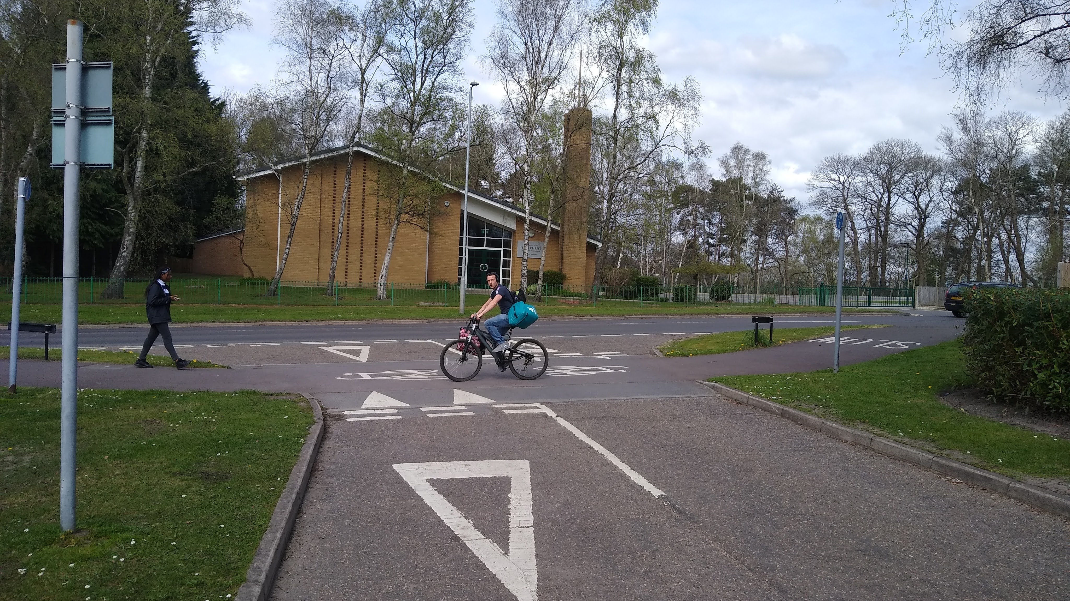
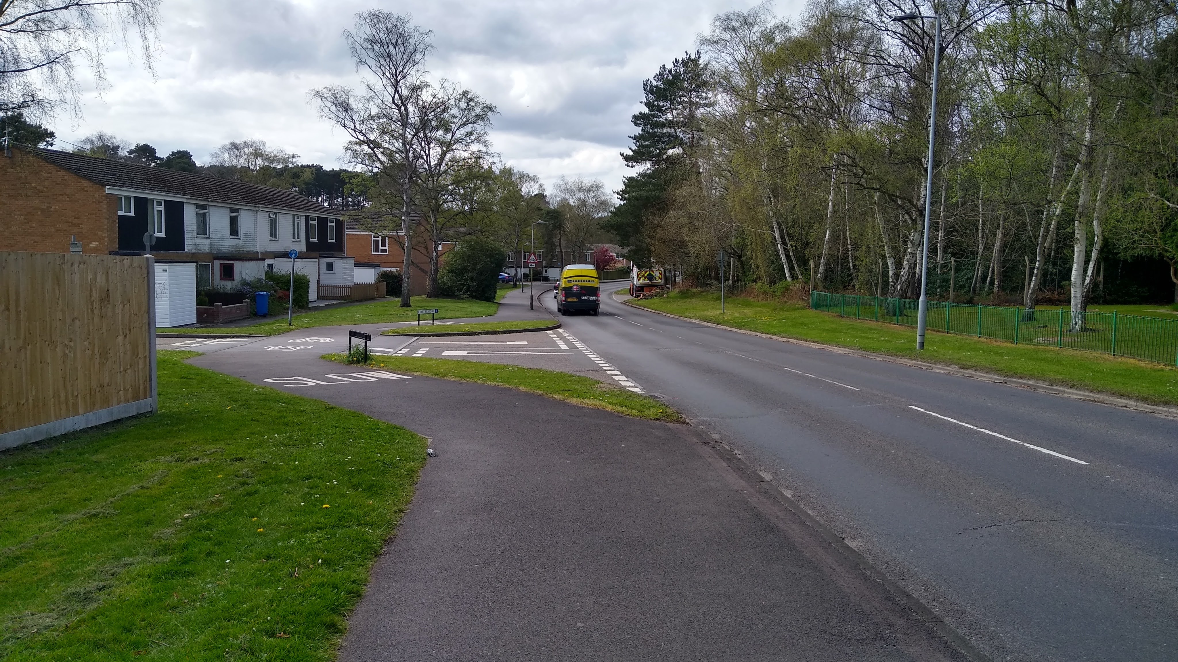
The western end of Ringmead gives walking and cycling priority over the side streets by bending the 3 metres wide shared path out from the main road and with the shared path being placed on a road hump such as at the junction with Cottesmore (above). This arrangement means drivers turning off Ringmead can do so into a little pocket before they need to cross the shared part (below) The movement being broken down into stages reduces the burden on a turning driver. This is an example of sustainable safety. Drivers exiting the side streets can cross the shared path and then wait in the same pocket before completing the turn.

From a walking and cycling point of view, the layout does mean diverting from the desire line a little (below), but having priority compensates for this as well as being inset into the side street means there is less need to look behind you when crossing.
It's hard to see from the photographs, but the surfacing is red (now very faded) and remains reasonable smooth and in good condition. Given the location, the pedestrian and cycle traffic flows would have been planned to be reasonable low and so would probably be reasonable against LTN1/20 as being appropriate where both modes are under 300 people each at the peak (Table 6.3). The junction with Birch Hill Road gives general traffic priority as it is another distributor road where homes would generally be accessed from other locations by cycle.
It's an interesting curiosity and the regulations permitting such an arrangement go back decades. This was adjusted in 2016 (Traffic Signs Regulations & General Directions 2016) to remove the need for the road hump, but I would generally advocate using in any case one to force driver speeds right down. LTN1/20 suggests that for a cycle priority crossing like this (Table 10.2), the flow to be crossed with such an arrangement would be up to 4,000pcu (two-way) a day (passenger car units - a traffic flow converted to standard cars) with a maximum of two traffic lanes crossed at 30mph or below. This also means around 400pcu at peak (two way).
Every case will be different and personally I'd like to see lower flows. With Ringmead, this is also a shared path which means people walking will find it less easy to find gaps and take longer to cross, so I'd estimate flows need to be around half.
As I mentioned earlier, there are also cycle routes with separate footways. Just down the road, there's another section of Ringmead which is still a distributor, but it meets the A3095 Crowthorne Road in an interesting way. At this junction, it's not possible for general traffic to access Crowthorne Road and so it's effectively pair of no-through-roads. There is a left turn from Crowthorne Road onto Ringmead which I assume fits the wider motoring network plan.
From a cycling point of view, Ringmead is quiet here and so cycling is on the carriageway connecting to local streets to other cycle routes to the north, although some of these seem rather lonely. Crowthorne Road is not for walking or cycling and the crossing of it is rather interesting.

Walking and cycling cross via an underpass which drops gently under Crowthorne Road which is itself at a higher level than the adjacent residential areas. Ringmead rised to meet Crowthorne Road at a signalised crossroads which is essentially a pair of bus only roads with a bus crossing of Crowthorne Road. In theory this means that an approaching bus can be given priority at the crossing point (I didn't see a bus cross myself).

I'll come back to the underpass shortly, but the eastern approach to the bus crossing has a section of bus and cycle road which carries a warning "sump trap ahead" (above). Just beyond the entrances to the underpass on both sides, we the get "no entry, except buses" signs (below).

A short distance after the no entry signs and just before Crowthorne Road, we see what a sump trap is. These are essentially large diamond-shaped blocks of steel which stick up above the carriageway surface in the centre of each running lane, with a traffic island separating each direction (below).

On closer inspection (below), the sump trap is recessed into a kerbed hollow which essentially gives access to vehicles with a suitable wheel track width and combined with the steel block, vehicles of a certain ground clearance can cross.

These sump traps are actually modern and were installed in 2010 to stop abuse of the bus only section by drivers. Because camera enforcement is only available in some parts of the country (and is was certainly much rarer in 2010), this was about the only way to discourage the abuse. This type of feature is incredibly rare in the UK, perhaps numbering less than 10 locations.
In the wider network, this layout also gives us an insight into a separate bus network which could provide a better level of service than driving, although this has to include bus lanes and priority through junctions on main roads to genuinely provide options, along with high frequency and direct bus routes.

As I mentioned above, the underpass is worthy of note. The local topography means the ramps to it are very shallow and there is a clear view through it for a long distance before one arrives at the portal (above). this means that the ability for people to hide there is somewhat limited, although ideally, a wall on each side extended out would reduce that further.

The bollards preventing people driving through (above) are not placed well on the eastern side (the far side in the photograph above) and they really should be a conspicuous colour. However, it's a pretty good example by UK standards and it means that people walking and cycling don't have to wait to cross a busy 40mph A-road. This design where the road is lifted to minimise or eliminate ramps really should be a standard approach in my view because there is no delay for anyone and conflicts are removed. Social safety is important of course and so clear views without hiding places are vital.

The footway though the underpass simple carries on along Ringmead with the cycle track meeting with a simple give way. There really is no need or advantage to cross the actual carriageway of Crowthorne Road.
So there you have it. Some interesting relics (with a modern twist for the sump busters) of the New Town movement which proves that the UK can and did plan for different modes, it's just that we still made driving aspirational and easy for trips within these towns leaving these interesting design details.
Driving through Bracknell is a drag due to the strange road layouts and the excessive use of oversized roundabouts (bad for anyone who gets carsick, such as young children). But I have a theory as to *why* it has so many weird layouts and horrible car-dominant nonsense: not just because it's a New Town, but because of the presence nearby (until recently) of the Transport Research Laboratory (TRL). I think TRL used their local town as a guinea pig. I can't back this up with hard evidence -- and we all know plenty of other UK towns have awful road layouts too -- but it seems like a bit too much of a coincidence ;)
ReplyDeleteTRL is still there. Although the old buildings have been demolished and most of its original site has been sold off, it still occupies a small corner.
DeleteI have cycled round Bracknell for work and leisure for some years. The cycle tracks serve the purpose of getting from A to B perfectly adequately. The only moan I have is that if you are not entirely familiar with the area through the estates the road/street names are the "car end" with no indication on the cycle track.
ReplyDeleteThe bus routes work well, although the chicanes are sharper than elsewhere. The sump busters are also found in Reading (or is over the border in West Berks?).