
At the end of September last year, I headed to Coventry, the UK's motor city to have a look at a project I had been following for some time - the Coundon Cycleway.
The story for me starts back in the Summer of 2020 when I had a chat with Adam Tranter, the Bicycle Mayor for Coventry, about an exciting project which was being developed in the city. I think he is still involved with active travel in the West Midlands.
The Coundon Cycleway was a plan to connect the city centre to an area north of the city, via the Coundon local centre and on a route giving direct access to several schools and community facilities with a plan to start at the Hill Street Bridge (over the city's ring road) and end at Norman Place Road by the Bablake Playing Fields which would provide a safe cycling route of some 2.8km.
The reason the project was exciting was both because it was in Coventry, a city with a solid reputation as being car first to the point where it scrapped bus lanes in order to deal with traffic congestion and where it's often referred to Carventry on social media; and that a high quality cycleway was being developed which had the potential to be one of the best schemes in the UK.
I got to look at the plans and was asked if I could provide a bit of a design review. As I am never shy about giving views on design I was happy to oblige and the project manager for the scheme, Peter Howarth, very graciously responded to the feedback and incorporated quite a few suggestions.

The council undertook public engagement and decided to proceed with construction which was fantastic news and in April 2021, I had a quick look at work in progress on the way back from a visit to Birmingham where I saw 30 kerbs being installed between the footway and cycle track on Hollyfast Road (above) as well as the very first use of the Charcon Entrance Kerbs being laid outside another entrance to the playing fields (below).

I watched the progress of the scheme on social media and was eager to get back for a look, so when my son needed to have a look around Coventry University, I was given a pass to spend a couple of hours exploring.

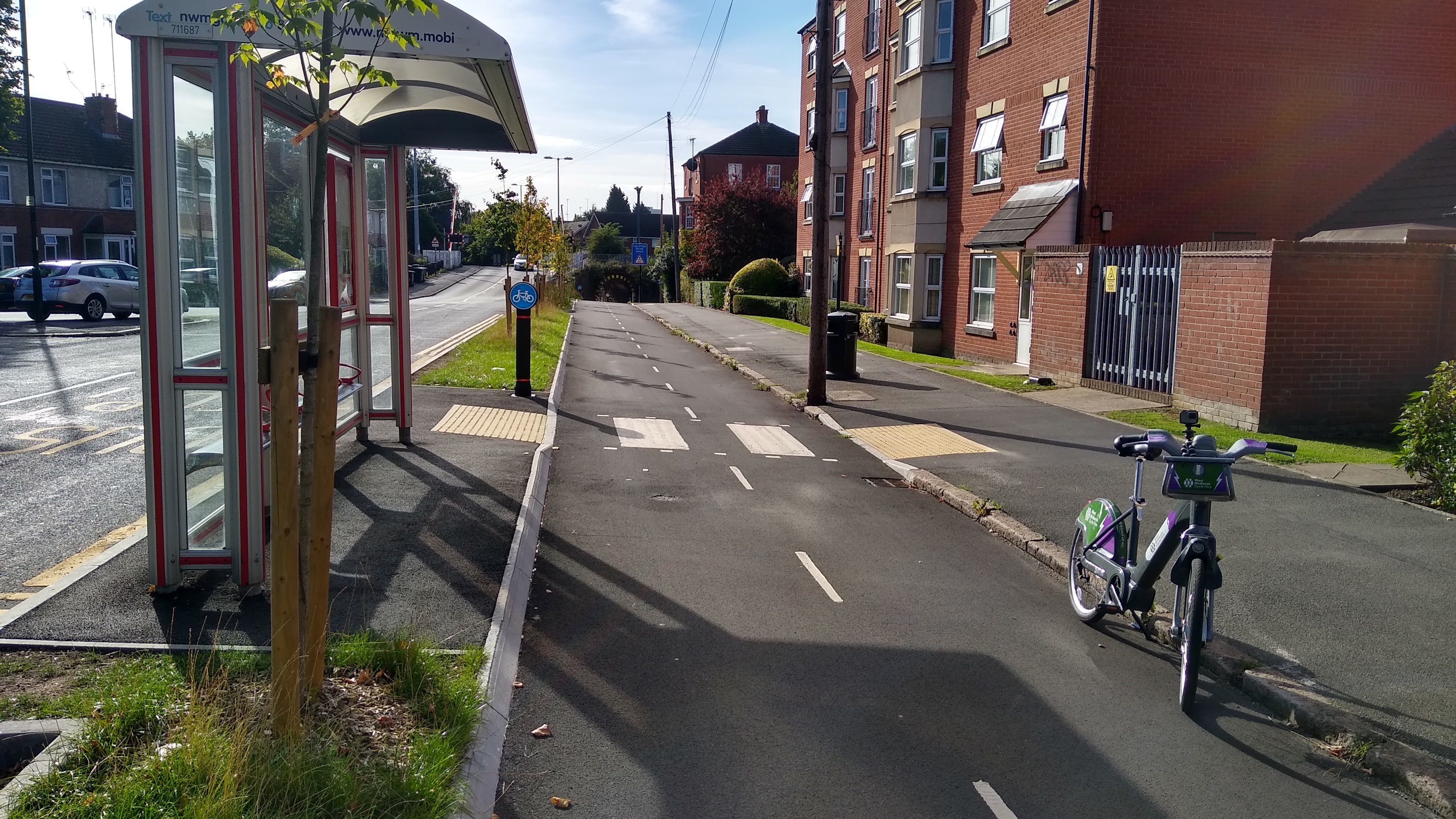
I had planned on using West Midlands Cycle Hire and I was pleased to learn that they had some e-bikes in the fleet and so after using one in Manchester a few months earlier, I found a suitable ride and headed to the Hill Street Bridge to start my ride and I have created a map to show the route.

The first 250 metres of the route is still to be completed. The first section in Upper Hill Street is a cul-de-sac and so there's a 175 metre section which is left unprotected for now. It wasn't too busy, but it will be nice to see it complete to give a real sense of protection and continuity. The infrastructure starts just before the junction of Coundon Road with Chester Street and we immediately get a feel for the treatment of the project (above).
The cycle track is a two-way affair on one side of the street which presents opportunities and challenges which is always the issue for debate in setting one's design approach for a project. The the Coundon Cycleway, the two-way approach responds to a localised opportunity and at the higher level it means car parking is largely maintained along the route. While the purist in me would love to tackle car parking, there is a political reality about actually delivering a project.

At the junction with Chester Street we immediately see the consistent approach taken with side road treatments and accesses with the use of continuous treatments (above) which carry the cycle track and footway across the side street which gives visual priority to walking, wheeling and cycling and which reinforces the Highway Code hierarchy which gives those moving ahead priority (Rules H2 and H3). My message to designers is that this should be your default approach, unless location conditions dictate otherwise.

Personally, I would have preferred the separate walking and cycling space to have been continued across the side streets and for tactile paving to be used on the pedestrian side (above) which could be a simple white line with applied tactiles (which I'll cover later). The ultimate would have been to reconstruct the footway approaching and through the side streets, but investment isn't endless and the treatment does the job fine. Drivers cross someone else's space and the use of the entrance kerbs keeps that space at the walking, wheeling and cycling level.

While we're looking at the continuous treatment, let's pause a minute and admire the kerbs which have made it easy to design and deliver. The Dutch Entrance Kerb by Charcon (part of Aggregate Industries), a unit I have been specifying at every opportunity and which is appearing all over the UK now. Coventry got there first. The photo above shows the special end units which provide a transition between a standard half-battered kerb and the sloping entrance kerbs. Simple and effective.

A little further north at Stanier Avenue and I spent a bit of time watching drivers cope perfectly well with the continuous treatments (above). It is almost as if the design principles for this approach which is common in the Netherlands and elsewhere on the mainland are understandable regardless of language.

To the north of Stanier Avenue, there is a railway level crossing which features a tunnel right next to it (above). This is where the two-way cycle track works a treat because the tunnel is now filtered and part of the cycleway. Previously, this tunnel was open to general traffic (subject to the height limit), presumably to bypass the level crossing when the barriers were down.

The tunnel itself is compact, but see-through and this is a great example of a bit of opportunism. My only grip here is there are (I assume) original stone setts which are uneven and slippery. They need changing, but that means working by a Network Rail structure and Network Rail are a headache to deal with.

North of the tunnel the street turns from Coundon Road into Barker's Butts Lane and the separation from traffic increases with a tree-lined buffer. It's worth looking more closely at the tactile paving used at the new set of dropped kerbs because it's quite unusual.

As I suggested earlier, we have "applied" tactile paving on the project which doesn't consist of the traditional concrete tiles, but a clever system that uses a grid of bobbles to form the blisters, over which methyl methacrylate resin surfacing is applied to get the effect above. Supplied and installed as Tac-Grid, the system does away with the need for installing slabs. I've heard good things about the system from a few people and I'll watch with interest to see what it's longevity is like, my guess is when used at junctions, it probably stands up better to any vehicle overrun if laid on a decent surface.
A little further on and we have the project's first floating bus stop. I thought the space here was a little tight between the shelter and the crossing point, although the bus doors would stop in line with the crossing point. The shelter with it's back to traffic means alighting passengers have a good view of the cycle track which is edged by the old kerbline. It might have been nice to have forgiving kerbs here, but again, a pragmatic decision was taken to keep costs down and just look at how much space was there waiting to be found!

Above is the exit of Duckman Court onto Barker's Butts Lane. It's a cul-de-sac, but with quite a lot of of flats and plenty car parking spaces. It's another example of the continuous treatment and because the side street is 7.3 metres wide, it is locally narrowed at the junction to shorten the crossing distance and so physically slow drivers in what widened to some 20 metres at the edge of the main road.

A little further north and we reach the edge of the Coundon local centre at the junction with Thamley Street (above). One of the problems with two-way cycle tracks is they only serve half of a street's frontage. One-way cycle tracks serve both sides, but you need crossing points to allow people to U-turn if they are heading the other way. One way to make access a bit more permeable is to have gaps such as at this location which is opposite the junction.

At the centre of Coundon, the route is crossed by Moseley Avenue and here we see an advantage of two-way cycle tracks because they are easier to thread through signalised junctions unless you are actually rebuilding the whole thing as a protected junction.

North of the local centre, there's another floating bus stop. I think this one is stingy on space, even though it doesn't have a shelter (the original layout didn't either. Traffic on the other side is actually forming two lanes for the Moseley Avenue junction, so that's where the space is being prioritised. The stop could go further north, but then it would be further away from the shops. It could have been south of the junction, but that would have removed car-parking and sometimes it's about what can pragmatically be built.

A bit further on and we meet the junction with Pake's Croft and a new modal filter. The filter means that drivers cannot use side streets to bypass the traffic signals at Moseley Avenue through some very narrow streets and as well as creating a new low traffic neighbourhood, it also provides a safe cycling connection to Moseley Avenue Park. Access is provided to the side street opposite and we end up with a tiny cycle track crossroads.

Further north still and the junction with Browett Road has been made exit only as part of managing local traffic and keeping through traffic on Barker's Butts Lane.

A touch further up and the cycle track crosses from the west side to the east side of Barker's Butts Lane the photograph above shows the signals changing to stop traffic as I approach. The Audi is illegally parked on the buildout, but here you can see car parking has been retained on both sides. I would have liked to have seen a parallel pedestrian crossing here which seems to have been a missed opportunity. It would be fairly simple to add one in.

As the cycle track continued, Barker's Butts Lane gets much steeper (above) and I was very glad to be on an e-bike which was a great combination with the car parking protected space - those using acoustic cycles are going to be wobbling a little bit to get up here!

The hill goes on for a while and there are the now familiar gaps to access site streets opposite as we proceed just as here at Laburnum Avenue.

The cycle track then arrives at a roundabout junction with Scots Lane where Barker's Butts Lane gives way to Westhill Road. The cycle track crosses the Scots Lane arm on a parallel zebra crossing (above), although sometimes drivers were not that attentive and being a linear route, there isn't really cycling connectivity to the other arms.

Just north of the roundabout, there's another floating bus stop with a signalised pedestrian crossing just beyond to create a little local centre interchange for the shops around the roundabout (above).

As I watched the ebb and flow of people at the bus stop, a couple of children passed me going uphill on their scooters in perfect safety. This is the enabling power of protected cycling space (above).


The access to the car park to the complex uses a continuous treatment for consistency (above).

Now the cycle track had it's final surface, I got to test out the kerb by riding up and down it (video clip above). This is why I constantly go on about "forgiving" infrastructure because here the slope meant I wasn't going to get thrown off and the 50mm height meant I wasn't going to catch a pedal.

The kerb (above) is also going to be detectable to those needing the help and it allows mobility scooter users and others who cannot dismount their cycles to join and leave the cycle track where they want and not where the designer allows them. Perfection.

At the junction with Norman Place (above), the cycle track bends from north to east into Norman Place itself, but a niftily laid out parallel zebra crossing allows people cycling to cross the road to continue north where they are safely reintegrated with traffic (I can't vouch for how much traffic). There is also way to access the cycle track to head south.

The route ends just after another floating bus stop which serves the playing fields (above) and where I had to turn around to head back to the city. And do you know what? When I got back to the Hill Street Bridge, I rode the project again because it is that good.
I have picked up on a few compromises in this write up and one other thing I would have liked to have seen would be a some mid-block gaps in the protection to allow people to cross from the other side to access the cycle track to maximise customer access. But this really is one of my favourite projects and it is both locally useful as well as useful for accessing the city centre. I'll leave you with my second ride because I filmed it!
An interesting assessment of Coundon Cycleway which I use most days, I've yet to watch your You Tube footage. Just to point out that Coventry's history was based on bikes. We had many bike manufacturers such as Rudge Whitworth and James Starley. It's good that locally we are returning to the bike. I am looking forward to the completion of the Binley Cycleway
ReplyDeleteIndeed, TfWM has been pushing the "Starley Network" as a name for cycle routes in WM, but so far agreement has been patchy. Looking forward to coming back to see the full Binley Road.
Delete👍
DeleteRode this last summer, good to read your comments. The Binley Road route is on my doorstep, so looking forward to your views on that!
ReplyDeleteI rode a bit of Binley, looking forward to seeing the whole scheme.
DeleteThats impressive!. More of this please...
ReplyDeleteYour suggestion for segregation of peds/cycles at the side road treatment - would the addition of tactiles on the ped side not contribute somewhat to diluting the continuation of the treatment and act as a visual indicator of a more traditional uncontrolled crossing and mix the message of the active mode priority? You may also have peds potentially hesitating to 'cross' and cycles not, further confusing drivers.
(Also noted that at the 'faux zebra's' to the floating bus stops theres a mix of buff/red/no tactiles at the crossing point - bit of a lack of consistency there)
On balance, as visually impaired users want tactiles to help with navigation (some people count junctions) and to know they are entering a space that they might find traffic, I'd use them. The mini-zebra crossings are proper zebra crossings for cycle tracks and should have red L shaped tactiles.
DeleteInteresting that the tactiles at the mini zebra crossings should be compliant, but no orange beacons (on black and white poles at either side) are installed. Are They not required or did they derrogate from standards?
ReplyDeleteMini-zebras don't require beacons, but they should have the correct tactile paving - being more human scale compared with the road.
DeleteNot visible on your video, but I don't think I'll ever tire of the view down the hill, where the Cathedral looms larger and larger as you approach the city centre.
ReplyDelete