The first time I visited Bradford, it was for the train driver to change ends at the station as I travelled between Manchester and Leeds, so a proper visit was long overdue. I put this right a couple of weeks ago.
I was looking forward to visiting the city after having been a sustainable mobility design advisor for some projects in the city centre before I was made redundant last year. Transport nerd and Bradfordian, Dave Stevens, had been encouraging me to visit for ages and so it is thanks to him for organising a whirlwind tour. I was actually going to a conference in Manchester, but when I said what's the best thing to look at, he said "Bradford". Arriving at the station, I met Dave and Kit, another transport nerd and we quickly dashed off to catch a bus to our first point of interest.
Those active on Twitter during the Pandemic might remember the run-up to Christmas 2020 where I did the #CyclingInfraWorldCup, which got very territorial. We were too cooped up; it was bound to happen. A project which made it as far as the quarter finals was Bradford's Big Red Bridge and I was excited to see it in the flesh.
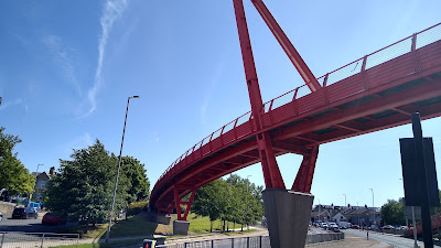
So guess what? It’s a bridge, that’s big and red, in Bradford. It crosses the A641 Manchester Road dual carriageway to the south of the city, reconnecting the communities severed by the road. It was built in 2012 as part of the Sustrans Connect 2 programme, which was supported by the National Lottery.
Designed by the city council's in-house team, the bridge works with the local topography across its east-west aspect as well as the steep hill which drops to the north towards the city centre.
In the centre of the main span, angled steel reaches for the sky (above) adding interest from a distance, but for me, it is how it works with the site levels and land constraints which is most interesting.
From Roundhill Street looking east, the sinuous nature of the bridge becomes apparent and over to the right (south), a spur from the main span drops south to meet the western side of Manchester Road (above and below).
The colour is a little faded these days, but it is certainly a landmark. Curiously the colour is consistent with that of the shelters and railings of the guided busway along Manchester Road (below).
The busway has stops integrated with surface-level signalised crossings and at first glance you might think this makes the bridge redundant, but in practice, the bridge is far busier because it serves a different desire line. Anyway, we jumped back on the bus back to the city centre.
The busway is a curious thing which runs is sections with gaps at the main junctions where the bus driver has to make sure they get it right as they re-join the separated sections.
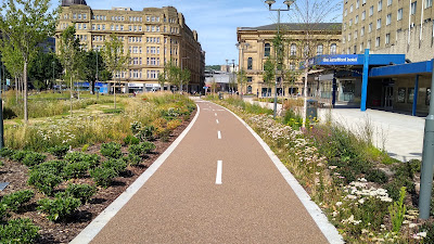
We then wandered over to Hall Ings which is at the heart of huge changes in the city centre. There has been a redesign of some of the roads and streets which skirt the city centre, along with routing of bus services in order to create a new park. The photograph above was taken from what was a dual carriageway running between the two buildings. It carved off the southern tip of the city centre, creating a barrier between Bradford Interchange station and the city itself.
We met a walk led by Dr Saira Ali, the city council's Landscape Design and Conservation team leader where we learned about some of the history of the area and the influences that led to the landscape design.
Strictly speaking, there is still a bit of a "road for vehicles" running through through space, but it's a wonderfully smooth cycle track (above), which sinuously, but directly provides a key east-west route. This is the part of the project I was involved with and where working with the city council team, we looked ensure that a decent connection was made. Wider changes are still a work in progress, but a stake has been claimed for future development.
Hall Ings is genuinely a park. There is open space, shaped grassed areas for sitting on and areas for incidental play. The planting in what has been incorporated into Norfolk Gardens, reflects the city's history of textile production with colours of the dyes used amongst other things.
The linear routes are also crossed by a bollard-controlled access to the magistrates court which is not successful at all (above and below).
The access road is designed to prioritise court traffic (of which there is generally very little). I argued against this treatment on the basis that drivers of court traffic should be competent to negotiate the space.
While I am on security, I'll also point out the hostile vehicle mitigation (HVM) which has been deployed, such as approaching the crossing of Princes Way (above).
As usual, the people who only give their first names have come out of their government buildings to tell the council they have to put lots of bollards and blocks in positions which obstruct walking, wheeling and cycling in the name of security.
The cycle track here is particularly poorly detailed - surely a group of three bollards should have been used here? This was after my involvement, so I had no chance to influence things. On the positive side, the pedestrian and cycling space remains separated at this crossing which was where a large roundabout once stood.
After looking around at a couple more things as part of the tour, three became four as we were joined by yet another transport nerd, Emma, and we wandered further east along Hall Ings. The photograph above is at the eastern end of the main park space looking west and again, this would have been the middle of a road just a while ago. The cycle route crosses a little bit of shared space which gives an opportunity to head north and south and which is fine in the context.
As we walked along, I was amused to see a telecommunications chamber which still had the old carriageway-loading cover, complete with double yellow lines. This is a little bit of street archaeology which serves to remind us of what came before. In fact, I think it would be fun to keep the lines painted and for there to be a little plaque to explain it!
As we headed further east, the cycle track curved to the south (above) as the road still exists here beyond the city core, but it has had a bit of a diet, with the two-way cycle track on the south side to avoid the complexities of the multiple accesses to the Broadway carpark.
Hall Ings then meets Vicar Lane which is essentially a 5-arm junction that has been remodelled. The southern arm of Vicar Lane used to be closed to traffic, but has been reopened as part of bus access changes, while the northern arm of Vicar Lane has been closed to traffic. To the northwest, previously closed Well Street has been reopened to traffic as part of wider servicing and access which means Bradford has pretty much now introduced a circulation plan.
The old layout here was a staggered toucan crossing with the northern arm of Vicar Lane being left in only and one-way, away from Hall Ings. The new layout needed to be signalised and the two-way cycle track threaded through to cross to the northern side of Hall Ings to be ready for a future extension. Rather than just take the cycle route through the junction, I thought that a creating a protected intersection would be much more flexible for people cycling (above).
The original plan was for a CYCLOPS variant of junction which has cycle traffic on the outside of pedestrians. This means that when people cross the cycle track, they turn before encountering the signalised crossing of the carriageway which provides assistance to some visually impaired users who like to have that change in direction.
However, on the southwest side of the junction we had to compromise as the design developed because of the position of an existing building. For this quadrant, we have the Dutch approach of in-line crossings which are more awkward for some people to cope with.
I was disappointed to see that my design for Vicar Lane North which was essentially a stub of cycle track providing direct access to the CYCLOPS was missing and there wasn't even a dropped kerb for access for cycles. Despite being steep street, the cycle access was there to maximise permeability.
I think the push buttons for the pedestrian crossings would have been better in the areas at carriageway level for long cane users to detect and to make sure people using amplified mobility could get as close as possible. I was pleased to see the contrasting traffic islands had made it into the final work as I think that helps to make the layout more conspicuous. I'll never like the green surfacing, but that's the council's preferred treatment, despite the dark buff of Hall Ings.
Finally, the two-way route re-joins to the northeast of the junction and continuous for a while with a floating bus stop (the bus stop being a relocation from elsewhere). In this case, the shelter is way too close to the crossing of the cycle track and blocks the through-visibility and I think the passenger island is too small for the numbers using it. Hopefully some of these issues can be reviewed.
One of the things the Hall Ings project has done is reveal the rich architecture of the city centre because rather than having to scurry about along and across a space dominated by motor traffic, one can actually relax and enjoy the surroundings. I'll leave you with a slightly older piece of public realm, the Mirror Pool (above) in Centenary Square which is great fun and another example of the city getting rid of roads in favour of people and a more liveable city centre which has been a work in progress for over 20 years.
We never really hear much about Bradford and that's a shame. The city centre public space really feels European and on the warm sunny Tuesday I visited, the city centre was busy well into the evening with people just hanging out and enjoying the spaces. Bradford should be shouting about what they have been doing!


No comments:
Post a Comment