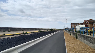
I have a list of things to go and have a look at, and in April, I added the new Clacton-on-Sea to Jaywick Sands path to that list after seeing Danny Williams tweet about it. It didn't stay on my list long!
I was in the town of Clacton-on-Sea visiting family, and as I had my folding bicycle with me, I was able to take a couple of hours out for a morning ride before meeting them for lunch. I headed down to the seafront and then west towards the village of Jaywick.
The new 1km path is shared for walking and cycling which contrasts with the 2.3km route for driving on roads most people won't cycle on. At 3 metres in width, it's going to be tight when busy and so it would have been nice to have seen a little extra space. To be fair, the project did had to fit between the coastal defences. As can be seen in the photograph above, space has been taken from the back of the revetment to the defensive wall (left), plus the path runs in front of the secondary flood wall along Selsey Avenue.
The photograph above is a little further west at Burnham Court which gives a better view of the main coastal defence. The large concrete kerbs on the left of the path have been incorporated into the base of the landward side of the defence to create the space and on the other side of the path, there is a gravel drain for surface water.
It's a pretty featureless route given the flood defence on one side and golf course for most of the length on the other, but it passes a Martello Tower (above) which is of local interest.
Further west still, the edge of Jaywick can be seen (above) and to the left of the flood defence, the sand dunes marking the eastern end of Jaywick beach.
The engineering of the path is excellent with a perfectly smooth surface and so even on a windy and chilly (for June) morning, there were people using wheels other than on cycles (above). The distance advantage over driving or trying to use the often narrow footways on the alternative road route, plus the path's quality gives people a real option to get to Clacton under their own, or e-assist power.
The route is lit using pv-solar and wind (above) which saved having to add power cables to the route which would have been very costly. I have used the system to power flashing traffic signs in the past and it proved reliable back then, so the technology must have improved by leaps and bounds since I last specified it.
Just beyond the end of the new path, the route joins the existing sea wall path which runs behind The Close and where the official NCN150 will turn north from to join Broadway via an existing ramp, although it is possible to just carry on west for a while longer.
The project was part-funded by the Getting Building Fund and is aimed to help provide better access for citizens in Jaywick (one of the most deprived places in the UK) to access employment and education as well as eventually providing a safe cycling route to Clacton station. More can be found on Essex County Council's project website.
I'll leave you with a video of the route from Clacton to Jaywick and then back again.


Looks good - if maintained.
ReplyDelete1 - Do you think there is any risk with the high kerb on the landward side?
(My thought - probably only for drunk people.)
2 - Argh. That barrier.
3 - Sand drift looks potentially problematic.
"If maintained" - a key point given how much Essex County Council goes on about being skint. Not sure why the trief kerb, but maybe it was an easy way to adjust the base of the defence compared with having to form and cast concrete.
Delete