
May is National Walking Month and this year I decided to go for a long and lonely walk which, quite frankly, I hated.
Last year, I walked from the boundary of London just beyond Junction 28 of the M25 to the King Charles I statue at Charing Cross, the traditional point from which distances to and from London were measured. Part of that route took me along the A12 Colchester Road which runs through my part of London in the borough of Havering.
It's an unpleasant road to walk/ wheel and cycle along as well as being hard to cross, but it is only a third of the issue for the northern part of Havering which also has the A12 Eastern Avenue and the A127 Southend Arterial Road to contend with.
These three roads are part of the Transport for London Road Network (TLRN) and are unashamedly designed and managed for the flow of motor traffic along them. They also meet at the notoriously named Gallows Corner roundabout, a maelstrom of traffic that includes an aging 1970s flyover between the Eastern Avenue and Southend Arterial Road which is currently being refurbished by Transport for London (TfL) with most of the investment coming from the UK Government.
Gallows Corner has a long history of being a political lightning rod with most local politicians being obsessed with trying to stuff more traffic through the junction. Havering's Conservative GLA member, Keith Prince has spent years campaigning for more motor traffic capacity to be added and so he must be disappointed that it's only a refurbishment. The Department for Transport is investing 85% of the cost (£57.3m) with TfL funding the rest (£10.1m).
The current project includes works to "... install new pedestrian and cycle crossings to make it easier and safer to cross", although there is nothing published on the project website. I saw early drawings which added toucan crossings to the Eastern Avenue arm, but the same drawings also showed degradation of the shared-use paths around the roundabout in favour of slip road widening. The problem with this being a maintenance project is that TfL has not undertaken any public consultation on the designs. Anyway, I will cast a detailed eye over the project when it is complete another time.
The only politician who has taken any interest in the other people trying to get around Gallows Corner is Green AM, Caroline Russell, who led a 2017 Transport Committee "Hostile Streets, walking and cycling at outer London Junctions" investigation which included Gallows Corner. The report had a series of recommendations which so far, TfL seems to have largely ignored in Havering. It is worth noting that the GLA Conservative group did not agree with the report because they didn't like the idea of lower speed limits and the "turning the corner" campaign.
Anyway I will come back to the wider issues later because I need to get on and give a commentary on my walk which started at Junction 28 of the M25 and ended near there after three passes through Gallows Corner, for what was essentially a circumnavigation of the three roads and so my photographs reflect the order in which I saw things.
The southern corner of Junction 28 of the M25 is within the current National Highways project to upgrade the shared-use path on the southern side of the junction to better connect the Havering and Brentwood sides of the junction. This should have been done when the M25 was built, and is only being done now because the Development Consent Order for the £140m to £170m addition of a slip road between the M25 and A12 eastbound made it a requirement after lobbying by Havering council.

When the project is complete, I will have a proper look at the result as I was part of a team designing the upgrade before I was made redundant last year, and I am eager to see how much of my advice was incorporated in the detailed design which took place after I left.
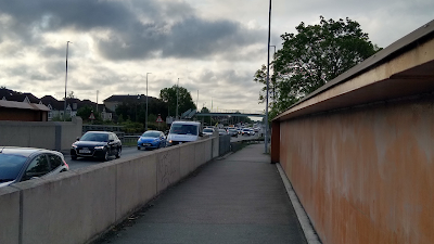
The photograph above is near the bottom of the westbound slip road as I headed towards Gallows Corner on the Colchester Road. I hope that lighting column is being moved outside of the path before the top surface is added. On the return leg, I had wanted to look at the new shared-use path on the northern side of the realigned A12 eastbound slip road, but despite being open to traffic, it was still closed to pedestrians and cyclists.

Away from the National Highways works, the first point of interest was the footway next to the first section of a service road (above) which runs from Maylands Way to Harold Court Road. For reasons lost to the mid-1980s dualling of the section between the new M25 and Gallows Corner, the footway was built at a high level next to the A12 and not at the lower level of the service road. I only discovered this high level footway a couple of years ago when it was cleared by TfL after years of being overgrown!

A little further on and the service road and A12 are at the same level (above) and the footway moves to the other side of the road. The service road is a problem for cycling because it is one-way with no contraflow (and it is quite narrow). This does need sorting out to connect the National Highways work to the shared path which starts a little further west.
The parade of shops here are now mostly converted to houses or are takeaways. Before the Tesco at Gallows Corner arrived in 1989, there was a small supermarket, a green grocer, a newsagent and post office. It is interesting to note the M25 fully opened, the A12 was dualled and a car-based supermarket opened nearby within five years.

Above is the first set of traffic signals heading westbound at Harold Court Road. This is where the derogated route 12 of the London Cycle Network starts which I'm afraid sums up TfL's interest in this part of London because it really should be improved and brought into its Cycleway network. This is a theme I saw all day. There is no pedestrian crossing of the A12 here, but people do cross from the north to the south to get to the parade of shops.

The first crossing of the Colchester Road is west of Harold Court Road and adjacent to Petersfield Avenue, and it is a vintage 1980s subway (above). The traffic flow on this section was recorded as just over 35,000 vehicles a day in a 2023 manual count and of this 79% were cars. The highest flow was just over 46,000 in 2011 which aligns with my perception that the Pandemic notwithstanding, there is less congestion on the road today.

Just beyond the subway, there is a signalised right turn into Petersfield Avenue, but again, no crossing of the A12. There is a pair of bus stops here serving the Romford to Brentwood 498 route and there is a well-used crossing desire line just beyond the bus in the photograph above. Despite the conditions, people want to cross using the most convenient route. Another theme I found all along. This location is also one of the TfL emission zone boundaries with the junction incorporating a U-turn facility for large vehicles which was built with the original dualling.

TfL has been reasonably proficient at ensuring there are dropped kerbs and tactile paving at the side roads along the Colchester Road, including at this electricity sub station which has a traffic count of a few vehicles a year, although they are grey rather than the usual buff! More seriously, the non-signalised side roads are all designed for flow which means the likelihood of drivers leaving the A12 giving way to people crossing is nil, although those joining often give way because they are moving slowly anyway.
In fairness to the GLA Conservatives comments about the hostile roads report, there is a grain of truth in what has become a rule in the Highway Code requiring drivers to allow people to cross when they turn into a side street; turning from a busy 50mph trunk road into a narrow side road really isn't a layout that supports someone stopping on the trunk road.

Just down from the sub station access is an uncontrolled crossing of the Colchester Road between Painesbrook Park and St. Neots Park (above). As well as the parks and people living both sides of the A12, there are primary schools here and Harold Wood station to the south, and as such, there are often people trying to cross here with over 35,000 vehicles a day and a 50mph speed limit.

In fact, this location features in my 2023 Transport Practitioners Meeting paper "Permission to cross: an alternative way of prioritising requests for pedestrian crossings", with the photograph above being one of the examples I use in my discussion. When you realise that there is traffic coming down the hill, you can see why the woman is hurrying across. It is also worth noting that there was a speed camera before this crossing which was removed by TfL because it was an obsolete wet film camera and it was on the justification that there were no injuries before or after its installation.

The photograph is the westbound approach to the Gubbins Lane/ Gooshays Drive junction which has the triple whammy of no buffer to 50mph traffic because the road widens for the junction, a narrow shared-use path and constant encroachment by the hedgerow. It feels really exposed.

The Colchester Road at least has a signalised pedestrian crossing on the eastern side. It should be a toucan crossing because both sides are shared-use and it is a staggered arrangement which operates on a "walk with traffic" basis (green men appear when conflicted traffic movements are held). It's a pretty busy crossing for people getting to nearby Harold Wood station and people often cross on the western arm which could very easily have the type of crossing added.
At one point, investment was allocated to this from local housing development and so it is unclear why the council and TfL haven't got this built.

The side roads don't have pedestrian phases and so to cross, one has to find a gap in the traffic streams and be prepared to cross quickly. Yet another theme for my day out walking.

There is a little bit of good news at the junction with Whitelands Way. There is a toucan crossing over the Colchester Road and Whitelands Way itself. The latter is staggered and really awkward to use on a standard cycle and much worse on a non-standard machine. The current layout is more recent and replaced the original 1980s arrangement.

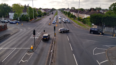
I then met Gallows Corner for the first time (above) and other than observing the school pupil crossing near the roundabout because southern side was closed to walking and cycling with a long diversion round the north side, I turned southeast onto the A127 Southend Arterial Road and headed towards Junction 29 of the M25 on the southern side of the A127.
The A127 was fully opened in 1925 and was an entirely new road built as an extension to the also new A12 Eastern Avenue, both through virgin land. The project was hand dug and provided employment for former WW1 troops. It wasn't dualled immediately, but this was completed by 1939.

It's 1km between Gallows Corner and the next junction at Ardleigh Green and despite this (above), there isn't even any dropped kerbs for those who might want to cross between the residential areas on both sides and the commercial and industrial uses around Bryant Avenue, including the 1989 Tesco.
This section also crosses the mainline London to Norwich and Elizabeth Line railways on a bridge rebuilt between 2014 and 2020 for around £32m, and which replaced the original 1920s structure that was reaching its end of life. Expensive things roads! Footways were widened on both sides, although people of course cycle given that this section of the A127 is 40mph and carries nearly 41,000 vehicles a day (2023 data).
There was a real missed opportunity to incorporate decent width shared-use paths here which could have been the first stage of better provision here and so this is now locked in for another century.
Then I arrived at the Ardleigh Green junction which is another signal controlled crossroads with Ardleigh Green Road and Squirrels Heath Road being the side roads (above, looking southeast). Squirrels Heath Road connects with Gubbins Lane and the pair of roads are often heavily congested at peak times, including people trying to use Harold Wood to avoid Gallows Corner. It is unashamedly managed for motor traffic.

This junction is often heavily congested, and as well as there being no green men on the side roads, there is no controlled crossing the main road which means people have to cross an aging footbridge which features unsettlingly open risers on the stairs or steep ramps. Cycling isn't banned, but it isn't really permitted either. There are schools both sides, and the A127 continues to be a formidable barrier to anyone not driving (or travelling by bus).

To the southeast of this junction, there are remnants of the 1930s era cycle tracks which connected Ardleigh Green with Southend. Although lots of this still exists, several sections have been eroded such as the junction with Wingletye Lane (above) which had slip roads built leaving a narrow footway and a crossing well into the side road. We'll come back to the cycle tracks in a while.

After the Wingletye Lane area, the residential areas on both sides give way to a more rural character with a 50mph speed limit and soon after the national speed limit just before Hall Lane. There are some occasional historic residential and commercial premises which somehow hang on (above) and which help to make walking on the southern side more awkward and inaccessible, especially as dropped kerbs are not flush anywhere here.

Next is the Hall Lane junction (above) which is a grade separated connection of the A127 to Hall Lane which runs between Harold Wood and Upminster. From the best I can work out, this junction was created in the 1960s along with lots of work to close right turns into and out of the many side roads along the road more generally. The slip roads associated with the grade separation did of course degrade the 1930s cycle tracks. Hall Lane is another entry point to the London emissions zone and acts as a turn round point for those wishing to avoid it.
The parapet on the southeast side of the flyover was changed to a higher arrangement in around 2013 as part of the provision of a shared use path for National Cycle Network route 136 delivered under the Sustrans Connect 2 programme, which I led on in Havering at the time.


For it's utilitarian use, I think the Hall Lane flyover is a a thing of faded beauty with some lovely details coming from the sloping 'T' shaped connections between the piers and beams that are actually contiguous units.

A bit further on is the last junction on this side and that's Front Lane to Cranham. Space is yet again eroded by slip lanes and yes, that is an uncontrolled crossing of a road subject to the national speed limit.

As I approached the M25 once more, the path was often overgrown and certainly narrow which was probably the most hostile part of a very hostile walk (above).

As I started up the westbound slip road from the M25 onto the A127, there was a glimpse of a path though woodland which connects to Moor Lane in Cranham which is part of a long since severed connection to Folkes Lane and Great Warley beyond. The Lower Thames Crossing (LTC) project promises a footbridge here to reconnect the area with a design due to be unveiled soon.
My view on the LTC is that it is incompatible with climate change and locally, it will throw even more traffic onto the A127. The footbridge should be built anyway, but National Highways is proposing it because the LTC will end up changing the operation of J29 of the M25 with "free flow slip roads" on the southern side of the junction which severs the ability for people to walk/ wheel and cycle to the Essex side of the junction.

For those wanting to, the new bridge will have a twin to the east of the junction and so they will need to cross to the north side, cross under the motorway and then cross south again - see page 8 of this document. This will close the route I walked which crossed the M25 on the western side of the roundabout under the M25 (above) near to the Havering border with Essex.
It is worth highlighting the work of Havering Cyclists here (part of the London Cycling Campaign) who have pushed for the bridges to enable cycling, and they remain vigilant to National Highways backsliding.

After crossing to the north side of the A127, I headed back towards Gallows Corner where the path was much wider and part of the 9 feet wide design of the Ardleigh Green to Southend cycle track. Even though the crash barrier eroded the useable width, it felt a hell of a lot safer than the 6 feet design on the the other side!
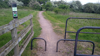
The outer parts of the A127 in Havering are rural, but large areas of farmland have been turned over to the Thames Chase Community Forest. There is an access to Pages Wood to the west of Hall Lane, but as you can see above it is designed for people who can negotiate a forest of steel hoops. This area is managed by Forestry England who "strive to remove barriers".

Back into the 50mph section saw me cross the access to a petrol station which had maintained the wide cycle track which was refreshing, seeing as how it was eroded elsewhere. This particular petrol station hosted a hydrogen facility until 2007 when a three year EU-funded trial of hydrogen buses by TfL came to an end. The local authority objected to the trial because of worries about hydrogen storage. These days, TfL is going the electric battery route.

As I approached the Ardleigh Green junction again, there was a short section of the 1930s cycle track as it reached an area with commercial and residential frontage with a verge separated footway (above). Oh what could have been.

It doesn't last long though and the space is given over to car parking for the residents living along this section of the road. There is some ability to cross the road here for the brave, and at school times, there is always children crossing here.

As I reached Gallows Corner once more, there was a reminder as I crossed the Colchester Road arm to get to the Eastern Avenue, that the Colchester Road was built on the route of a Roman Road.

I crossed to the southwest side of the Eastern Avenue as the footway on the other side would only run a short distance. As I crossed under the Gallows Corner flyover, there was a glimpse of the road being widened into the narrow footway for the junction works. I just hope what goes back is even wider than what is lost and that this arm gets toucan crossings.

The next section is semi-rural with a path down to about 1.5m in width, often uneven and full of cracks (above), but at least it is verge separated. This 1km section to Heath Drive really needs widening and designating as a shared-use path. It is handy for some trips to Romford town centre because it avoids cycling on the A118 which is mainly advisory cycle lanes.

A little further on and there is an uncontrolled crossing between Park Boulevard and Rise Park Boulevard (above). This connects Raphael Park on the Romford side to Rise Park on the Chase Cross side.

Despite this section of the Eastern Avenue carrying over 40,000 vehicles a day and with a 50mph speed limit, people still cross here (above) as the two parks help create a quieter walking/ wheeling and cycling route between Chase Cross and Romford.

The first major junction is at Pettits Lane (above) which is another large junction with no controlled crossings for pedestrians, but one can at least cross at the surface here.

The previous photograph was from the footbridge to the southwest of the junction which works with the general landform that drops from the Romford side on the south to the Collier Row side to the north. Cycling is banned on this bridge.

I crossed to the northern side of the Eastern Avenue as there is a footway for the next section and there is a really old floating bus stop on the A12 at Ashmour Gardens. Of course, because the floating aspect is a service road rather than a cycle track, it isn't controversial. Access to this stop and dropped kerbs more generally are really poor here. You can also see the high fence on the central reserve which is designed to physically stop people crossing - this you have to do at a subway in the distance.

The next junction is Havering Road/ North Street (above) which has a staggered signalised crossing on the northeast side.

As I have now established to be the common treatment, the side roads here don't have green men and so it is back to trying to find gaps in the traffic to cross (above).

On the southwest side of the junction there is another subway which despite its bright walls is a deeply uninviting place to be, so I carried on.

The footway runs along the King George Playing Field which has its faded 1936 gates locked with a modern astroturf complex beyond which is of course owned by a private equity company.

The last junction on the Havering section of the Eastern Avenue is at Mawney Road (above) which is the usual signalised crossing of the main road and thoughts and prayers on the side roads. At least here, there is a signalised (staggered) crossing both sides of the junction. I crossed back to the southern side because the footway runs out very soon.

To the west of Mawney Road, there is a shared-use path built in around 2016 which was essentially a widening of the extant 1.5m path. This version is machine laid and verge separated representing the standard that should be provided along the more rural sections outer London TLRN roads. Unfortunately, this section is ruined with a layby and a site access.
I had reached the end of Havering once more and as I turned round to trudge back to Gallows Corner for the third time, I remembered a blog post about the next junction at Whalebone Lane which is as fun to navigate as you've come to expect.

After passing through Gallows Corner, I reached Tangent Link which is the vehicle route into the Harold Hill industrial estate and this time, controlled crossings of both the main and the side roads are provided (above). Beyond this, the path gets a verge buffer and on the approach to Gooshays Drive, there's a hedgerow and separate lighting, although these does feel more lonely as a place.

As I got back to the Petersfield Avenue subway that I passed earlier, I headed down it (below) and decided to call it a day after over 18 miles and 9 hours of being out (including time for photos and rests). Besides, there is a convenience store round the corner with a good line in European beers!

It was a long, and towards the end, gruelling day. In truth, I hated most of it and there was very little to redeem these three roads. I knew the suburban sections weren't nice to travel along or to cross, but the level of general cleanliness was probably worse than I expected and the noise and fumes debilitating. The outer end of the A127 certainly felt the most hostile. So where does this leave my thoughts?

I've shown the hostility out on the roads and with the traffic flows and speed limits, they are way beyond any measure of reasonableness in terms of recognising that they are significant sources of community severance. But let's look at casualties (above). Since Transport for London was created in July 2020, there has been (give or take) 2,000 people killed and injured on the three roads within Havering (excluding the M25 junctions, with data to December 2023).
Of this toll, 30 people have been killed and 213 seriously injured. One might say that given the thousands of movements a day, the actual 'by trip' risk over 23 years is very low and that's right in terms of cold data. Some people might even take the motonormitive view that this is the price to be paid for the freedom to drive and made those trips.
I don't think it is acceptable and what is more, so many of these deaths and injuries could have been prevented and so I want to take a little time to give some ideas of what could be done.
The most obvious thing is for TfL to heed the Hostile Streets investigation report anyway and in particular to review the speed limits. It is a tricky one to some extent because some of these roads have sections which feel like motorways and simply putting a sign up will not get drivers to slow down and so I would like to see changes in speed limits backed by average speed cameras. My starting points would be:
- Colchester Road to be 40mph from the M25 to Whitelands Way which extends the short section of 30mph near Gallows Corner. I would like to push further, but there are sections without frontage which will become a political bunfight and things can be revisited. Don't forget, the shared-use paths here often have no buffers to traffic.
- Southend Arterial Road to be 40mph from east of Hall Lane to east of Wingletye Lane and then 30mph all the way to Gallows Corner because the eastern end has much denser residential development fronting the road.
- Eastern Avenue to be 40mph from east of Gallows Corner to Mawney Road. There is a section between Ashmour Gardens and Havering Road which should be 30mph because of the residential frontages, but short sections of a lower limit will also be a political bunfight.
With these speed limits and average speed enforcement, there starts to be a much easier case to provide signalised crossings in key places to help people cross all three roads. 50mph and higher speeds have a poor safety record with standalone crossings, hence my caution. The precedent to look at is the A10 Great Cambridge Road in Enfield which has sections of 30mph and 40mph.
Lower speed limits and crossings are not guaranteed to be completely safe, but rebalancing is needed to give people the ability to cross who might not be able to do so now.
I didn't take photographs of all of the uncontrolled site roads which are basic priority junctions (give ways for traffic joining the main roads). As I said earlier, drivers really are not going to stop on high speed roads to let people cross and so the obvious improvement from a pedestrian (and cyclist) perspective would be to ban the right turns in with physical changes to the junctions (here is an example further west on the Eastern Avenue). This means pedestrians only have to worry about drivers coming from one side and who will be more likely give way anyway.
For those needing access to the side streets, they will have to use the nearest signalised junction. I am stopping short of full filtering because most of the side streets could not accommodate turning heads for delivery and refuse vehicles. These changes will also reduce the risk of shunt collisions with people slowing to turn off the TLRN and reduce 'friction' to some extent.
Next would be a review of permeability. There are lots of places where people could be provided with walking (and cycling) access to the paths on these roads which would be as simple as adding short path links from roads running parallel and more tricky, where land might have to be acquired.
In all cases, cycling should be permitted along all of the paths along these roads and signed accordingly. The service road between Maylands Way and Harold Court Road needs to be redesigned to provide a protected eastbound contraflow, and the footway parking near Ardleigh Green and sections of the Eastern Avenue redesigned to properly enable cycling.
In the long term I would also like to see work on the southern side of the Colchester Road to swap the shared-use path with the vegetation to provide an actual buffer. There also needs to be investment in just the most basic of maintenance of surfaces, sweeping and vegetation management.
Then the main junctions then need to be tackled with the starting position of providing accessible toucan crossings on all arms which will include secondary push button positions that everyone can access. This will impact motor traffic capacity, but it has to change. It is far from perfect, but the Little Heath junction on the Eastern Avenue further west is the basic model to follow.
Notwithstanding the works at Gallows Corner now, there is still a need for better access around it and the provision of toucan crossings on all arms. The basic level of provision has already been considered by Havering Cyclists and this should have been incorporated into TfL's current project. This needs to be revisited and implemented in full.
In short, TfL needs to develop a specific Local Implementation Plan for the TLRN in Havering and local politicians, including AM Prince need to pull their collective fingers out as this is on them too.
People often think of London as being progressive in terms of sustainable mobility, but this often misses outer London and at least from Havering's perspective, it really feels that TfL and the Mayor have given up. Given the mode shift that the Mayor's Transport Strategy wants to deliver, this seems like folly.
Finally, in order to service inner and central London, people also forget that the motor traffic performing that role has to run through the communities of outer London. We are not just commuter dormitories for central London, we are places in our own right with local and town centres, schools and employment areas that we need to get to, often along and across the TLRN.
Update 20/5/2025
The A127 footbridge winner has been announced; Arup and Seán Harrington Architects design is for a timber glulam bridge which will have a low carbon impact. On the largest roads project in the UK.
*****
Thank-you for this, Mark. I enjoy a cross-section of an aspect of a place.
ReplyDeleteI think you need to be sure you write your own epitaph, or someone will find something like this, and it will be consequently very distinctive !
A great review - This was my "commute" from Essex to the now historic Eastway cycle circuit in Stratford/Hackney - Doesn't look to have changed too much!
ReplyDeleteThe lack of controlled road crossing on Colchester Road by Paine's Brook has always struck me as absurd. Such a desirable route between Harold Hill and Harold Wood, especially given one side has the station. Would be a nice cycle ride if it were possible to cross the road safely at this location!
ReplyDelete