
A couple of Sundays back I took a ride back into my engineering past which started in Hatfield, Hertfordshire and ended at Stevenage (with a loop around the town).
It was a sort of a London Cycle Safari takes a day trip outside the city to see what is happening elsewhere (and getting out of the London bubble is a good thing). Luckily it wasn't Billy-no-Mates, Alex and Hester were present; and as it turned out, we did 39 miles which was no mean feat. Alex and I were on folders and Hester with a 3-speed step-through (with a missing gear) which made the hills interesting!
I'll get to the point shortly, but by memory lane, I am referring to our starting town of Hatfield. In 1991 I left the Big Smoke (well the suburban part of it) for 4 years to study. First, I completed an HND in civil engineering at Hatfield Polytechnic which took 2 years and by the time I completed a degree in the same subject, the college had become the University of Hertfordshire. During my time there, transport was mainly walking, with the occasional bus when carrying the shopping home.
Cycling for me was a kid's memory (Grifter, BMX being a child of the 70s and 80s) and apart from one housemate one year, I didn't know anyone who cycled; and it wasn't a form of transport which appeared with any great prominence in my lectures. There must have been a spark though, because the idea of environmental sustainability was planted in my head and this has gradually grown over the years. Something good must have stuck. I will single out Professor Roger Duffell as being the inspiration - an engineer well ahead of his time on engineering, society and sustainability.
Anyway, I'd been meaning to pay a return visit to my erstwhile home to see if I might cycle for transport there today (having not visited for over a decade). This post will concentrate on Hatfield and a future one will cover Stevenage (it might be next week, depends what comes up!).
Anyway, we met at Hatfield Railway Station which had been spruced up since my days. A pretty standard looking public realm scheme had been recently completed and despite the A1000 Great North Road having had a bit of a road diet, the space released is given over to a big drop-off parking bay. The footways have been improved and an X-crossing installed at the junction outside. The X-crossing has toucan crossings around it and puffins on the 'X' - I assume because cyclists crossing on the X would be a conflict (it's of course daft).

The junction is also interesting in that one arm is a little cul-de-sac and another is an exit from a bus interchange (to the right of the photo above). This means the toucan across the bus arm rests on green for walking and cycling with buses being let out as an when needed. In fact, I thought it a pretty clever use of the layout. On the eastern side of the A1000, the footway had been widened to a shared-use cycle track, but it was the usual UK give-way-at-side-roads affair which isn't worth writing about.
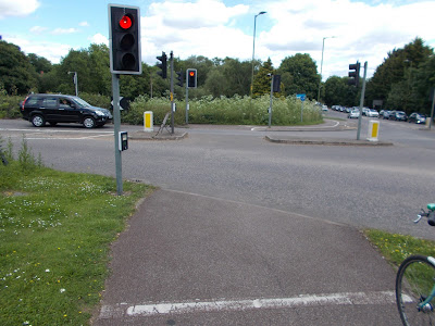
A bit north of the station, the A1000 turns east onto the Hertford Road at a signalised junction which has also been improved from a crossroads with no green men to a crossroads with a staggered green man crossing on the Hertford Road arm, complete with cyclists dismount signs (photo below). Very poor indeed. From there, we turned west towards the town centre onto St Albans Road East and after squeezing onto the footway over a railway bridge we were on the road.

As we approached the town centre, I remembered that it has a section of dual-carriageway to one side (Queensway) and so I suggested we got off the road to use a subway to get into the shopping centre. As we entered the town centre (through the Kennelwood car park) we found that cycling is simply not welcome (photo below). Curiously, the other side of Queensway has a shared-use cycle track which helps you avoid the town centre. Presumably those using cycles don't need shops.

It seems that somebody got a job lot of signs, some of which I can only assume have proper Department for Transport Special Authorisation to use because of their breathtaking non-compliance with regulations (one for the sign geeks there!);

For those as sad as me (and it's a niche joke for about three of us), the above sign means "end of footway parking for cycles and start of footway parking for pedestrians". White Lion Square is the focus of Hatfield Town Centre (and I lived above one of the shops as a student) and although it was a Sunday, it was deserted. Apart from a cafe, nothing else was open as my photo below taken at 11.15 shows.

According to to Welwyn Hatfield Council's Cycling Strategy;
"As with the redevelopment of Hatfield town centre, measures will be introduced to improve access for cyclists. It is envisaged that safer and improved access will be considered. This would link the west of the town centre at and around the Council Offices and Oaklands College through to the town centre in Stonehills and Fretherne Road. Cyclists could then continue to use Longcroft Lane and join up with the Great North Way at Stanborough Road."
Given that this was for 2003 - 2008, it appears nothing at all was ever done to create cycling access to the town centre. In 2011, the local press were reminding people that they risked being fined for cycling in the town centre because of the traffic order banning it. According to Hertfordshire County Council at the time;
"While we want to encourage cycling, it’s also very important that cyclists respect pedestrian areas. We hope these new signs will help emphasise where the pedestrian areas are in Hatfield town centre."
From what we could see, the layout of the road network does a far better job of stopping than a few signs could. Of course, at one end of the town centre there is a large supermarket with a large car park which explains who the target customer is.
We walked our bikes through the town centre and through the supermarket car park to St Albans Road West, pausing at another one of my student houses. At the end of St Albans Road West is The Galleria, a large out of town-style shopping centre with lots of parking. It's been there a long time and it has an interesting story behind it (which you can read about here). We weren't there for shopping, we were looking for infrastructure and we stumbled upon a curious relic at The Galleria;

As we were looking to cross the A1001 Comet Way, we found a ramp down into an underpass with a separate cycle track with the footway stepped up next to it. It's a pity The Galleria is supported on columns which go into the track.

It's not the best example as there isn't a clear view through and so social safety isn't great, but it shows we have built grade separation. The underpass emerges in Jetliner Way (other side of underpass shown below) which is at the edge of the old British Aerospace site which has been redeveloped for housing and business;

As we entered this newer part of Hatfield, we were given some half-decent infrastructure to ride on;

We were away from traffic on our own cycle track, although it was of its time with giving way at accesses and the track and footway the wrong way round (people like to walk as far away from traffic as possible). But it's pretty good. We did find interest at a roundabout (yes I know) which had been laid out very well indeed;

Anyway, we met at Hatfield Railway Station which had been spruced up since my days. A pretty standard looking public realm scheme had been recently completed and despite the A1000 Great North Road having had a bit of a road diet, the space released is given over to a big drop-off parking bay. The footways have been improved and an X-crossing installed at the junction outside. The X-crossing has toucan crossings around it and puffins on the 'X' - I assume because cyclists crossing on the X would be a conflict (it's of course daft).

The junction is also interesting in that one arm is a little cul-de-sac and another is an exit from a bus interchange (to the right of the photo above). This means the toucan across the bus arm rests on green for walking and cycling with buses being let out as an when needed. In fact, I thought it a pretty clever use of the layout. On the eastern side of the A1000, the footway had been widened to a shared-use cycle track, but it was the usual UK give-way-at-side-roads affair which isn't worth writing about.
A bit north of the station, the A1000 turns east onto the Hertford Road at a signalised junction which has also been improved from a crossroads with no green men to a crossroads with a staggered green man crossing on the Hertford Road arm, complete with cyclists dismount signs (photo below). Very poor indeed. From there, we turned west towards the town centre onto St Albans Road East and after squeezing onto the footway over a railway bridge we were on the road.

As we approached the town centre, I remembered that it has a section of dual-carriageway to one side (Queensway) and so I suggested we got off the road to use a subway to get into the shopping centre. As we entered the town centre (through the Kennelwood car park) we found that cycling is simply not welcome (photo below). Curiously, the other side of Queensway has a shared-use cycle track which helps you avoid the town centre. Presumably those using cycles don't need shops.

It seems that somebody got a job lot of signs, some of which I can only assume have proper Department for Transport Special Authorisation to use because of their breathtaking non-compliance with regulations (one for the sign geeks there!);

For those as sad as me (and it's a niche joke for about three of us), the above sign means "end of footway parking for cycles and start of footway parking for pedestrians". White Lion Square is the focus of Hatfield Town Centre (and I lived above one of the shops as a student) and although it was a Sunday, it was deserted. Apart from a cafe, nothing else was open as my photo below taken at 11.15 shows.

According to to Welwyn Hatfield Council's Cycling Strategy;
"As with the redevelopment of Hatfield town centre, measures will be introduced to improve access for cyclists. It is envisaged that safer and improved access will be considered. This would link the west of the town centre at and around the Council Offices and Oaklands College through to the town centre in Stonehills and Fretherne Road. Cyclists could then continue to use Longcroft Lane and join up with the Great North Way at Stanborough Road."
Given that this was for 2003 - 2008, it appears nothing at all was ever done to create cycling access to the town centre. In 2011, the local press were reminding people that they risked being fined for cycling in the town centre because of the traffic order banning it. According to Hertfordshire County Council at the time;
"While we want to encourage cycling, it’s also very important that cyclists respect pedestrian areas. We hope these new signs will help emphasise where the pedestrian areas are in Hatfield town centre."
From what we could see, the layout of the road network does a far better job of stopping than a few signs could. Of course, at one end of the town centre there is a large supermarket with a large car park which explains who the target customer is.
We walked our bikes through the town centre and through the supermarket car park to St Albans Road West, pausing at another one of my student houses. At the end of St Albans Road West is The Galleria, a large out of town-style shopping centre with lots of parking. It's been there a long time and it has an interesting story behind it (which you can read about here). We weren't there for shopping, we were looking for infrastructure and we stumbled upon a curious relic at The Galleria;

As we were looking to cross the A1001 Comet Way, we found a ramp down into an underpass with a separate cycle track with the footway stepped up next to it. It's a pity The Galleria is supported on columns which go into the track.

It's not the best example as there isn't a clear view through and so social safety isn't great, but it shows we have built grade separation. The underpass emerges in Jetliner Way (other side of underpass shown below) which is at the edge of the old British Aerospace site which has been redeveloped for housing and business;

As we entered this newer part of Hatfield, we were given some half-decent infrastructure to ride on;

We were away from traffic on our own cycle track, although it was of its time with giving way at accesses and the track and footway the wrong way round (people like to walk as far away from traffic as possible). But it's pretty good. We did find interest at a roundabout (yes I know) which had been laid out very well indeed;

This is the junction of Tamblin Way/ Mosquito Way/ Dragon Road. The roundabout has single lane entries and exists for motor traffic so that people walking and cycling only have to cross one lane at a time, rather than the multiple entry lanes we're always being. The crossing refuge points are fairly wide and they're deep enough for all types of cycle. The roundabout is also reasonable compact and so driver speeds were low;


The basics of a good design are there. It would be better to have the crossing points set into the side roads more as a driver waiting to enter the roundabout would block the crossing point. It would also be good to have a central over run area on the roundabout to further squeeze car drivers (but allow large vehicles to pass). We could easily rediscover this layout, tweak it, and use it all over the place where we have this type of estate design.

The photo above shows the entry into the roundabout. It is very hard to turn left at high speed because of the tight kerb radius on the nearside. For those going ahead, there is no direct path - they have to steer left then right; an over run in the middle would slow them down even more. It was a quiet Sunday morning and so at peak times, crossing opportunities might be harder, but at the time we were there, we didn't see any drivers go through quickly.
After the roundabout, we headed towards the university's College Lane campus (which was the main campus when I was there). College Lane used to be a bit of a rat-run when I was there, but it's now filtered with a bus gate. Curiously, one of the footways is a shared use cycle track, but it's so narrow in places as to be useless. Our conclusion was the track is there to get people cycling out of the way of buses!

We only spent a few minutes at the campus to indulge my nostalgia. Car parking seems as popular as it was in my day, although I did glimpse some covered cycle parking. The road through the site is still laid out for motor traffic which separates the main campus from some other buildings and bizarrely there were signs to remind pedestrians that traffic had priority at crossing points.
We then headed back along College Way to pick up The Alban Way, which is a path created from a disused railway which was the Hatfield to St Albans branch of the Great Northern Railway;

It was mainly pleasant, if secluded in places. Along the section we rode, there were connections to housing and other streets which means the route has some utility use. At one point we crossed St Albans Road west (the road to the Galleria) which was about as close to the town centre it gets.


Above, The Alban Way crosses Lemsford Road, sadly not on the old railway bridge which has long gone to leave its abutments to prove it was there.
We eventually arrived back at the junction where the A1000 turns into Hertford Road and we joined a shared-use cycle track (NCN 12) to continue our journey north. We passed a floating bus stop;

We then continued along a section which appears to have been constructed as a shared-use track, but "upgraded" to be segregated with paint. The route crossed Lodge Drive with an unlawful use of the "elephant's feet" road marking;

At one of the slip roads for the A414, we used a old (but helpful) cycle signals;

By now, the route was a shared-use cycle track again. Given that we were away from places people would be walking, it was an appropriate treatment. It was also coloured red which was interesting - could there be a little bit of Dutch influence.
At one point, we had to cross the A1000. We were given a refuge, but it was tight and would have been no use to those with trailers or longer non-standard cycles. Even on a Sunday, the road was busy and it took a while to find a gap.

We continued a while longer where the track had received painted separation from the non-existent pedestrians (below);

We then headed back along College Way to pick up The Alban Way, which is a path created from a disused railway which was the Hatfield to St Albans branch of the Great Northern Railway;

It was mainly pleasant, if secluded in places. Along the section we rode, there were connections to housing and other streets which means the route has some utility use. At one point we crossed St Albans Road west (the road to the Galleria) which was about as close to the town centre it gets.


Above, The Alban Way crosses Lemsford Road, sadly not on the old railway bridge which has long gone to leave its abutments to prove it was there.
We eventually arrived back at the junction where the A1000 turns into Hertford Road and we joined a shared-use cycle track (NCN 12) to continue our journey north. We passed a floating bus stop;

We then continued along a section which appears to have been constructed as a shared-use track, but "upgraded" to be segregated with paint. The route crossed Lodge Drive with an unlawful use of the "elephant's feet" road marking;

At one of the slip roads for the A414, we used a old (but helpful) cycle signals;


By now, the route was a shared-use cycle track again. Given that we were away from places people would be walking, it was an appropriate treatment. It was also coloured red which was interesting - could there be a little bit of Dutch influence.
At one point, we had to cross the A1000. We were given a refuge, but it was tight and would have been no use to those with trailers or longer non-standard cycles. Even on a Sunday, the road was busy and it took a while to find a gap.

We continued a while longer where the track had received painted separation from the non-existent pedestrians (below);

And then finally for this post, we entered the outskirts of Welwyn Garden City where we joined a ramp which was a tantalising example of some more highway engineering which we seem to have forgotten.


