Saturday, 30 May 2020

Most Highway Infrastructure Is For Motor Traffic

It's a bold statement - "most highway infrastructure is for motor traffic", but bear with me and I'll try to explain.

It's pretty obvious that motorways are designed for motor traffic and in legal terms they are not places that people are allowed to walk, cycle or ride horses. Of course, motorways do connect with other roads where people are allowed to walk, cycle and ride horses, but attention is on getting motor vehicles to move quickly between the two. This is why we get this type of Walking, Cycling & Horse Riding (WCHR) provision which is the current Design Manual for Roads & Bridges speak for People Not Driving;


This is the junction of the M25 with the A12 and A1023. The WCHR provision for the clockwise on-slip is a couple of signs and dropped kerbs. The anticlockwise off-slip is signalised and has a toucan crossing, but only because of the need to manage traffic flow on the interchange's roundabout - the toucan was added when the slip road was widened from 2 to 4 lanes in 2008 which presumably meant it was previously harder for people to work out when to dash across.

The toucan crossing is not provision for walking and cycling, it's actually there as a result of the slip road being widened and the designers realising that an unsignalised crossing of 4 lanes of traffic is probably quite a tricky thing. The on-slip of 2 lanes is maybe fine for people cross in the designer's mind - the pair of warning signs are not provision for cycling, they are maybe a result of the designer's private realisation that the layout is awful - imagine the struggle that went on.

Of course, you may think my commentary is flippant - how else are we to manage interactions where people and traffic meet? For sure the problems with this layout have their roots decades ago when the decision was made to build the M25, but the widening scheme in 2008 was about capacity increase rather than making things safer for people crossing - we monetize journey time improvements for people driving, but improving the experienced safety of people crossing this severing infrastructure doesn't appear in the sums.

Looking at motorways is an extreme example, so lets go back to the start. There is debate and disagreement about why kerbs were invented, but my favourite one has to be around the ancient city of Pompeii. The streets had kerbs with raised sidewalks because the lack of sanitation meant the streets were open sewers.


In the photograph above which Jeremy Burge kindly provided for City Infinity's Joy of Kerbs guidance, you can see the kerbs and raised sidewalks and also stepping stones which helped people cross the road - stepping stones to get over the filth because there needed to be space on each side to get carts through. Perhaps there's an analogy with streets which are traffic sewers and zebra crossings!

It's a pattern often repeated whether it's the raised boardwalks of the pioneer towns in the Wild West of the USA or footways in the cities of the UK built a couple of hundred years ago. The use of kerbed footways protected people from the filth of the streets and indeed the widespread use of horses and horse drawn carriages which were't compatible with the soft bodies of people walking around.


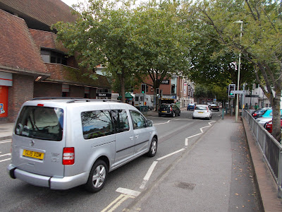
Who is this footway for, people walking or people driving?

Fast forward to the 21st Century and if I asked the question of why we're building kerbed footways, I'd lay odds that most people would respond that they are provided for pedestrians because isn't that just obvious? What if I told you that in fact, we're building kerbed footways to protect people walking from people driving or perhaps to keep people walking and people driving separated? We're building kerbed footways for people driving.

Once we turn the logic onto its head then it leads to other questions. Is the humble pedestrian refuge walking infrastructure or motoring infrastructure?


Why do we put in a pedestrian refuge? It's obvious - it's to help people cross the road in two parts. But why do people need to cross the road in two-parts? Well, it's because the road is busy - oh look, is the penny starting to drop? Pedestrian refuges are a staple of "local safety schemes", those local authority investment programmes which look at collisions in an area and install "stuff" to stop them happening again. Of course, those same refuges then get hit by drivers which then costs everyone to keep putting right and the schemes are about the continued accommodation of driving.

Most Highway Infrastructure Is For Motor Traffic is everywhere when you start to think about it. Dropped kerbs are not for wheelchair users, they are there as a result of footways being needed to separate people walking and people driving; in fact it's dictating where wheelchair users may cross the road. 

The need for kerbs to help visually impaired people find the edge of the footway so they aren't entering driving space is the result of there being driving space in the first place. The tactile paving created as the compromise between wheelchair users and visually impaired people at dropped kerbs is only there because of driving space.


Then (inevitably) I have to mention cycling. The people who loudly complain about the costs of all those cycle lanes being built and not used at a cost of millions to the taxpayer have missed the point. Putting painted rubbish to one side, the proper cycle tracks built on main roads are motoring infrastructure. They are there to keep driving and cycling separated because that is the only way we can get most people who don't cycle to start cycling.


The photograph about is Blackfriars Bridge in Central London. Before this cycle track was built, the only people who cycled were the fit and the brave. Since being built it has created a transport choice for thousands of people. The costs associated with it are generally framed as being "for cycling", but in fact they are incurred as a result of driving - we need a significant amount of investment to help people feel safe and to physically protect them from people driving.

And so it goes on. Traffic signals are there because of driving. Traffic signs are largely there because of driving. Pay and display parking machines are there because of driving. Traffic calming is there because of driving. Even a significant majority of highway maintenance spend is required because of driving. All of this stuff is only necessary because of how we have enabled driving to be such an easy thing to do.

If one delves into old places where motor vehicles are banned or mainly banned, then we see different streets such as the old part of Deventer in the Netherlands which is pedestrianised and mainly lacking kerbs. Cycle access is permitted although people cycling through will go a different way.


Or how about a modern example closer to home such as Francis Road in Waltham Forest which is no longer a place to drive through and so has largely been stripped of it's motoring infrastructure other than where it's completely required;


Of course, I am not suggesting driving ends tomorrow because that would be daft (although I do want a low traffic future). We are still going to need cycle tracks on main roads, pedestrian crossings and modal filtering, but we should be bolder in our assertion that the costs of this infrastructure is largely because of the motoring culture we have and therefore the infrastructure is largely for motoring, not walking or cycling.

The Covid-19 crisis has shown how unfairly space has been distributed on our streets and so funding is being invested in pop-up space for wider footways, cycle tracks and modal filters. The usual suspects are pushing back against this, but again, it is absolutely clear that the investment is needed to stop people being chased off the streets by motor vehicles. This work is actually motoring infrastructure.

Yes it is a strange train of thought and it turns what we "know" completely on its head. But if you properly think about it, Most Highway Infrastructure Is For Motor Traffic.

Saturday, 23 May 2020

#LDNCycleSafari Goes Solo: Q6 Part 1 - Barkingside to Wanstead Flats

I had aimed on getting some London infrastructure safaris running in 2020, but the Covid-19 crisis has put the kibosh on that plan. However, with the easing of the lockdown I thought I could at least go out and look at some newish infrastructure on my own.

So, last Saturday, I pedaled myself to Barkingside to go and have a look at Quietway 6 which runs from Barkingside Underground Station to the eastern edge of Victoria Park. Except it doesn't, the main part of the route ends at Chobham Manor with the Olympic Park being a gap in the network for some reason. Here is the route shown on TfL's cycle map;


You can see the gap to the southwest of the word "Stratford". For this trip, I actually ended the ride at Aldersbrook Road (at the City of London Cemetery) which gets us about half way along the route through the section in the London Borough of Redbridge (5.7km from Barkingside Station). It had taken a while to get to Barkingside and as I'm not superhuman, the second half will follow at some point.


The route "starts" at the fine Underground Station in the car park where suburban commuters are treated to lots of parking as compared to the small cycle store to the left of the building (which I hadn't noticed until I reviewed the video of my ride).


The sign opposite the station marks the start with a 9 minute ride to Valentine's Park. An interesting choice of destination given that nobody lives in parks and only a select few work there.

The route winds its way around back streets which at least on a Saturday morning during a pandemic (semi) lock down where genuinely quiet. Because the route was winding, one has to keep an eye out for signs and road markings to wayfind. You miss it and you're lost in suburbia.


This sign seems to have a mistake because the picture says use the road to head back to the station, but the sub plate says use the crossings of which there are none. 

There is some genuinely new (and useful) infrastructure. At the junction of Horns Road and Princes Road, a new toucan crossing has been installed along with a new separated cycle track providing a connection between Princes Road and Ashurst Drive. The cycling link is show below and if you look carefully, the toucan crossing is on the top left of the photograph.


It's a nice smooth surface, but unfortunately the demarcation between the cycle track and the footway is poor and the cycle track has tactile paving. A carriageway level/ stepped cycle track would have been better.


As one follows the cycle route approaching the crossing (towards Barkingside shown above), people cycling are invited to use the crossing and there's a helpful line showing how one must wiggle to get round. We've been using this arrange for years but it really does work for all types of cycle because of the inevitable tight turns and and transitioning from cycle track to carriageway and vice versa.


The photograph above shows the route taken using the crossing (I'm looking towards Princes Road). The yellow route is towards Barkingside and the purple towards Valentine's Park. The transition is a dropped kerb just beyond the 20mph road marking and so it means manoeuvring right where general traffic is turning in and out. In addition, there is no easy way to join or leave Horns Road. The guardrail belies an earlier layout where there was a pelican crossing on Horns Road on the other side of Princes Road.

The answer would have been to filter Princes Road, either fully or with one-way out for general traffic to give space for a proper "landing" for the crossing. Horns Road itself is a bus route and I wouldn't be surprised if it were an awful place to cycle under normal circumstances. This is the major flaw of building routes like this because they don't connect with any other parts of a network (because there isn't one).

It does rather make one ask if this end of the route actually serves a purpose other than helping a few local people get to the Underground Station because it doesn't do much for getting to the centre of Barkingside where there are shops!

Beyond Ashurst Drive, we are again into the backstreets. At the network level, there is no modal filtering whatsoever and I would put money on Ashurst Drive being awful at rush hour because it directly connects to the A12 Eastern Avenue to the south. There's footway parking everywhere and I can imagine lots of conflict from people driving out of the side streets all along this part of the route. I did notice some old London Cycle Network signs in the area, but this is not infrastructure which seems to connect up.

The route zig-zags along a couple of other streets to meet the A12 at the junction with Otley Approach. It's another risky transition where people are turning onto and off from the A12.


In the photograph above (towards Valentine's Park), one is expected to bounce up the pedestrian dropped kerb onto a shared piece of path to access a staggered toucan crossing over the A12. This crossing has been in placer for many years and has been a toucan since 2015 and so Q6 merely recycles what is already there. At least the refuge area is wide to allow access for most wheeled users, although people using larger adapted cycles and cargo cycles will struggle with two 90° turns and some people will struggle to reach the push buttons at all which is a major flaw with toucan crossings.

South of the A12, were have another transition into the carriageway of Lynton Crescent which naturally takes place at the A12. In the case of Otley Approach and Lynton Crescent, they need filtering to make the side streets exit only for motor traffic to provide decent landing space.

The rough sketch below shows what I mean. The purple is where the footway is widened to give better space for cycling and where drivers can only join the A12. The people cycling would pull into the widened areas via a dropped kerb, but it would be gentle and they would do so square to it. Once they have crossed, then they are dropped onto the right side of the road anyway.


The green shows the crossings where there is a slight change in direction rather than the stagger to reinforce the two stages - potentially near side signals would be needed to prevent look through to the wrong set. Having a bit more space could allow an extra push button to be set back for people who have trouble reaching a conventionally placed button.

The other thing we need to do is link the two crossings so it's timed to give a green for the second half without needing to push another button; that or some detection because people on the island only have two choices of where to go! Of course, I would rather see walking and cycling space separated, but the A12 doesn't have cycle tracks and it's not always clear if the footways are for cycling (but I'm not cycling on the road there).

The route into Lynton Crescent carries along for 200 metres before entering Valentine's Park immediately after crossing Perth Road, a street which I would bet on being another awful rat-run at peak times. The entrance to the park is a right/ left wiggle onto an odd buildout before you enter the park which is on a "give way to pedestrians" basis - i.e. a shared path.


You'll see the park in the video which I'll put on my YouTube channel at some point. The park is nice enough, but the only highlight is a set of uplighters (above) which mark the path edge. These may well be a complete waste of time because as I exited at the Emerson Road gate, a sign informs us that the park closes at dusk rendering it completely useless as a transport route.


As one leaves the park, one crosses Emerson Road into Bethell Avenue which is slightly awkward being in the inside of a curve. At the end of Bethell Avenue, cycle traffic peels away from general traffic because of an historical layout which used to have a triangular traffic island in the middle of a large junction. One side of the triangle is "plugged" and leads to another toucan crossing.


This crossing is over the A123 Cranbrook Road which runs from the Gants Hill Roundabout to Ilford Town Centre. It's a typically awful Outer London A-road which is fronted by homes and parades of shops, carries multiple bus routes and is hostile to walking and cycling. Q6 at least helps one avoid the traffic, but it avoids the homes and shops that a utility route would service. The toucan crossing awkwardly leads into Cowley Road;


On my large cycle, I couldn't make the tight right turn before the bollard and so ended up on the pedestrian side of yet another shared path. The transition into the carriageway on Cowley Road follows the usual theme for this route, although at least here the transition is at least away from the junction with Cranbrook Road;


If Cowley Road had been filtered for exiting traffic only, then a parallel crossing could have been provided (either signals or a parallel zebra). The image below shows a 2-way cycled track in purple, a cycle crossing in green and a pedestrian crossing in red. This would have make life better for people walking and cycling with a direct and legible layout.


Cowley Road marks the start of another back street section of the route which has a couple of turns before eventually entering Wanstead Park where Q6 points towards Manor Park (below).


By the looks of it, this is an established cycle route given the faded painted segregation as one enters. Very shortly after entering, there's a steep section which takes one over the A406 North Circular Road;


The route then heads into the open spaces which are pleasant enough, but of no practical use on a dark winter's evening in sideways rain;


Beyond the park, the route rejoins residential streets at Empress Avenue;


The route changes direction again into Wanstead Park Avenue which then joins the A116 Aldersbrook Road. Again, another cumbersome crossing of Aldersbrook Road which required a sharp right turn in the junction and then a U-turn via the ordinary zebra crossing which someone forgot to make a parallel;


The route then heads southeast on a shared-use path for around 200m to the junction with the A117 Forest Drive (yes lots of A-roads out this way) In fact there is an advisory cycle lane on the other side of the road heading southeast to give a whiff of the dual-provision to design which blights the UK. Just before the junction, there's another parallel zebra crossing;


In fact, the purpose of the crossing is to scoop up people cycling on the road from the cycle lane who have decided to join of the off road part of Q6 and to access the City of London Cemetery, the latter being the first useful destination the route serves which is morbidly humourous. At this point, Q6 carries on along Forest Drive, but I bailed and headed off back to Ilford on Aldersbrook Road. There's no protection on Aldersbrook Road on which people drive fast and so most people wanting to make utility trips won't use it. Section 2 of Q6 follows in another post.

Sunday, 17 May 2020

Practical Materials

Even a weekly blog cannot keep up with the changes being made in some UK cities on some streets to help enable walking and cycling by giving people space to get exercise and to maintain physical distancing.

However, it's still a relatively small length of streets being treated and we've the triple-whammy of inertia stopping more;

  • No money,
  • Council officers worried about liability with "pop-up" features,
  • Lack of political will,
I can't help much with the first and last point, although money is always relative in a local authority and political will is a euphemism for either can't be bothered or doesn't want change - a willing politician will ask for help.

Anyway, for council officers (and campaigners), I thought I would talk about the kind of materials which could be used together with a little help on assessing risk.

Materials
The cheapest material is paint and as well as cycle lanes, it can be used to mark areas and space; maybe to brighten up a piece of repurposed road on an interim basis until an area is redeveloped. Of course, paint along does not provide physical protection.

Old road repurposed as walking space at
the O2 in London

Traffic cones are ubiquitous elements of roadworks and they can be used to create all sorts of layouts. They are generally aimed at managing drivers and are traffic signs in their own right. They can be used to set out the edge of walking or cycling space, but probably best where it's separated from motor traffic.

Cones - we all know what they look like!

The big disadvantage of cones is they are relatively easy to move (willfully or being driven into) and so will require regular checking. A semi-permanent development of cones is the traffic cylinder also know as wands. These are fixed to the road surface and are less at risk from being moved than cones, although they won't physically stop a motor vehicle (although that's not generally the aim anyway, even with a kerbed cycle track).

Wands used on CS7 in London.

Cones and wands have the advantage that people can walk between them to cross the road and so the next few products need to have gaps left if we are to facilitate crossing the road. In some cases, the materials I set out below could be useful at the start of a run of cones or wands to just add a little protection.

Water or sand filled barriers are another feature of roadworks. These are plastic barriers which come in small units which are hooked or bolted together and then filled with water or sand to give them mass. They do provide a degree of errant vehicle mitigation because being linked, their mass acts together. There are also concrete versions of this, but they are harder to move around.

These water-filled barriers are providing a
temporary layout in Luxembourg City, in the
UK they would generally be red and white units.

Beyond the materials I have described so far, we move into semi-permanent territory. Products such as MASS barriers are used to protect roadworks sites and weak bridge parapets from vehicle incursion. Their profile and mass help redirect errant vehicles.

MASS barriers protecting weak bridge parapets.
Note the impact-absorbing end units.

Varioguard barrier is often used for long term layouts or for permanent protection and together with MASS barriers, we are probably getting beyond what we are aiming for with interim layouts.

Varioguard barrier.

Of course, there are other things we can use such as planters, concrete blocks and armadillos/ orcas - anything we can place at regular intervals to reserve space for walking and cycling, but to exclude motor traffic.

Armadillo lane separators used correctly in this
example where they are angled to deflect drivers from
this contraflow cycle track.

The examples so far are for linear space creation and is potentially costly if rolled out over long distances. A cones and paint solution may cost up to £10 per metre and a wands and paint version perhaps £20 per metre. 

With water filled barriers and the like, they are generally available to hire, but after a few weeks there will be a cut-off point where it's cheaper to purchase, but many local authorities and their contractors don't have an endless supply of storage space.

Modal filtering will be a much cheaper way of providing low traffic space and creating networks of low traffic streets immediately gives space for physical distancing. The cheapest solution is to use road closed signs with cones and barriers, but they are too easy to shift and required constant checking.

A simple line of bollards is probably the cheapest decent solution and when used in odd numbers with 1,500mm air gaps, provides a decently accessible feature for cycles and mobility scooters;


Timber Planters are a nice way to add interest to a street and with a bit of community help, they can be brightened up.

Timber planters used for filtering along with
bollards in an earlier modal filter in 
Waltham Forest, London.

The beauty of timber planters is that they can be easily made from stock timber using a hand saw, cordless screw driver and screws. I have had a quick look on Travis Perkin's website (other suppliers are available) and found a 47mm by 225mm section timber, which is fairly simply used to make a planter. Just line it with some permeable membrane to allow water to drain out, some large gravel at the bottom and then planting medium;

This (upside down) planter is 1,247mm square
by just over 900mm high. If the three cross
pieces at the bottom are doubled up, then the
planter can be moved with a pallet lifting trolley.

Of course, there are heavier timber sections available, but I'm looking at trying to keep the costs low and thinking about the ease of cutting timber without power tools - something a road work crew can easily knock up on site. Group a few together in the street with some temporary seating and the place is transformed for very little money.

Cheap pedestrianisation in Malmö.

For something a little more utilitarian, concrete blocks are easily available such as the Legato series - the LG3 at 800mm cubed is a pretty good choice as a standard 7.5 tonne truck with a hiab can shift them about - again useful for term contractors (and explained here);


So we have lots of options and combinations. Maybe a plan for an area would be some low traffic neighbourhoods with some pop-up footway and cycling space on main roads. If there's some more cash available then maybe the odd zebra crossing or parallel zebra crossing could be put in to help link low traffic neighbourhoods together?

Risk
I'm not going to write much in this section because I have covered design risk and liability in detail here and here; plus risk assessment here. Designers really shouldn't worry about design liability if they write down what they are doing and why with risk assessments undertaken commensurate with the scale of the works and the local circumstances.

A decent statement to explain what is being done and why it's needed is a useful starting point together with a literature review (what guidance is out there). Then a discussion about the local context and the objectives of the scheme. Round off with the discussion of why particular decision designs have been taken.

In our current response, there's probably little point in going into dry local policy details, but frame the work as the Council's response to the Covid-19 crisis and refer to the Government's Statutory Guidance. As a rule of thumb for designs, make sure they are conspicuous to all highway users day and night. If you feel some garish colours, reflective stripes and lots of signs are warranted, then go ahead because this stuff doesn't have to be pretty. Also, please make sure that things are kept accessible because we are designing for everyone - get some help if you are unsure.

Also make sure what you do is reviewed by others - not to shift the blame in the event there is an issue (being sued for design work is so rare, it's hard to find cases), but to get a sense check on your approach. I think the main things which will happen will be around people tripping over stuff, may be clipping it as they pass on their cycles or driving into it because of confidence exceeding skill. As a designer, do what you reasonably can to mitigate the risks, but you can never eliminate them totally.

I heard a phrase from an army officer as I watched a webinar recently. He said "simply good enough" - that's where we are. If we keep some of this stuff (and I really hope we do), we can improve it later.

Sunday, 10 May 2020

A Little Bit More

A few weeks back, I decried the lack of help provided by the Government on making helpful changes or clarifications to the law around traffic orders in the face of Covid-19.

I didn't want to return to the subject, but given the announcement yesterday around funding for walking and cycling in England (the other administrations have this devolved) I had to have a second look.

Sadly, my perpetual cynic's eye wasn't disappointed because there's largely nothing new, although there are a couple of things to be positive about and those are doors we should be kicking down.

On the funding, there was a ripple on social media yesterday afternoon around a £2bn investment. But alas, it's money which was already announced in the last budget - not helped by the announcement's headline "£2 billion package to create new era for cycling and walking" - well it's going to take that and more to create and maintain that new era. 

However, there are two positives. First, £250m is going to be made available within weeks as emergency funding. And given that there are 156 (I think) English highway authorities (thanks Sabre, assuming I've picked the right list) there will be some useful funding in the pipeline. Mind you, it's not a huge sum and it will need to be deployed cleverly and where there are district, town and parish councils involved, there's going to need to be some joined up thinking.

The highway authorities which do take up this funding are best advised to use it for as much as they could make permanent as possible which could be a combination of measures I've already suggested and Experimental schemes around modal filtering which provides a significant impact for modest investment. Trying to built lots of linear schemes will eat that budget up very quickly.

Beyond the funding, the rest of the announcement mentions Greater Manchester which has lots of well-advanced plans and so funding will be useful, but it won't be the £1.5bn the region needs. It also mentions the "bike Tube" network which hasn't been mentioned in London for a few years, but which was part of Boris Johnson's and his cycling commissioner, Andrew Gilligan's, plans when they were in City Hall. Perhaps one is the PM and the other one of his advisors has led to this flashback!

We're also told of the updated Cycling and Walking Investment Strategy which is to be launched in the summer. Well given that the current one runs to 2020 this was on the cards anyway. What is good about the announcements, though, is the funding has not be cut to be shifted elsewhere and previous commitments are being honoured. So we'll take it. 

The summer announcement will include a national cycling and walking commissioner and inspectorate, higher permanent standards (which I assume is the long awaited rewrite of the Local Transport Note for cycling infrastructure design) and long term budgets as we currently have with road schemes.

The current announcement includes Statutory Guidance produced in accordance with S18 of the Traffic Management Act 2004. This is useful because Statutory Guidance explains what an authority must to do comply with the law and so its contents is both a stick to hit authorities with, but also a comfort for those wanting to do the right thing as implementing the guidance can be relied upon. 

In this case S18 Statutory Guidance explains how a traffic authority can meet it's wider obligations under S16, also known as the Network Management Duty. The guidance will be reviewed in 3-months time. Of course there is current Statutory Guidance for S18 and this new guidance simply adds to it. The current guidance came out in 2004 and I'm not convinced that it has been particularly taken that seriously by some in any case.

The guidance provides a compendium of all of the "stuff" that we can do with temporary footway widening, cycle lanes, pop up cycle tracks etc. In fact, it's a list of stuff we could do pre-Covid-19, but an official list I helpful I guess. I know it's stuff we could do previously because the guidance states;

"None of these measures are new – they are interventions that are a standard part of the traffic management toolkit, but a step-change in their roll-out is needed to ensure a green restart."

So, not new, but now more urgent and there's funding coming to help. There's also some new traffic signs coming out to help with social distancing but in fact they are not all new. There's five signs aimed at people on foot reminding them to keep their distance (and the distance can be varied which I assume would fit with relaxing physical distancing rules). The problem is, many footways are not wide enough now and I certainly hope these signs (if used) are nor simply put on the footway! 

The other new sign is about a new road layout for social distancing, presumably aimed at people driving who are in a rage that their space has been reduced. The other six signs are existing. To be honest, the signs will have a limited role, but might be useful for some situations.

Further into the Statutory Guidance, there's a list of the traffic orders we can use and a link to the temporary publicity guidance published the other week, but the interesting point is about temporary traffic orders which are for street works, works to prevent danger and street cleansing. It states;

"Temporary: these can be in place for up to 18 months. There is a 7-day notice period prior to making the TRO and a 14-day notification requirement after it is made, plus publicity requirements. These are most suitable for putting in place temporary measures and road closures."

Now, I am not a lawyer, but the last line reads to me that the Government has confirmed that "danger" tacitly means anything related to managing Covid-19. It would have been nice for an explicit confirmation of the law, but this is probably enough comfort to help the willing highway authorities which wanted to use temporary orders but were worried about doing so. My advice remains that using experimental orders would be better, but having the temporary orders being implied as being legitimate might help out.

There are other things which could have been done. There is a reference to School Streets, except outside of London, there is no ability to enforce them by CCTV which has been recently confirmed by Sylvia getting conformation from the DfT, so when the schools do return it's going to be a labour-intensive process using civil enforcement officers or people raising/ lowering bollards. The other matter could have been to deal with the parking in mandatory cycle lanes loophole which Cycling UK has been pushing for.

OK, I'm coming across as being a cynic - well that's because I am. There is some positive news, but I am sure it has only come as a result of the constant pushing by all sorts of people and organisations. Just remember, the Government could be a great deal more radical and the fact it isn't it a choice. Keep battering on that door people!

Saturday, 2 May 2020

A Village Treat

This week, I'm returning to the Dutch village of Terhole which I visited back in 2017. It's a nice little place, but the reason to return is to have a closer look at the traffic calming in the village.

It's very interesting for me to go back and review some of my previous infrastructure safaris (which my family calls "holidays"), because with the passing of time, I've learned a little more and it's nice to go back and provide some more detailed commentary.

As is usually the case in the Netherlands, we cannot simply look at a place in isolation because over the years, road network changes have taken traffic away from the village. In 2003, a tunnel was constructed to the east of the area (to cross the estuary separating two parts of the Zeeland land mass) replacing the Kruiningen to Perkpolder car ferry to the north, (although there remains a foot/ cycle ferry).

The village itself was then bypassed with a regional road in 2004, the N290 Rondweg Terhole (Terhole Bypass), which meant that most through traffic had been removed from the village. This is interesting in its own right as the old road network remains essentially as service and access roads for farms in the area with links onto other small country roads; some of which are filtered to prevent through traffic access.

An undated aerial photograph of Terhole before
the bypass. This would have been a busy north-south route.
I've added the roundabout and bypass in red
Photograph from Terhole.info

The southern end of the village is accessed from a roundabout which connects with the N290; the use of the roundabout being a safe way of making the connection compared with the risks of priority junctions. At the northern end of the village there is another roundabout connecting with the N689, itself connecting with the N290 again 180m to the southwest. The N290 heads west (and is the route to the tunnel which crosses the estuary) and the N689 heads north to connect some towns and villages.

The N290 is on the far left with the old main north-south
road in the centre which leads to the village. A fairly standard
rural cycle track is to the right.

Although traffic through the village is now light, there was clearly a concern about driver speed. From the north, drivers leave a roundabout and immediately enter the village which has a 30kph (20mph) speed limit. From the south, it's some 1,300m from the roundabout from the N290. This approach has a 60kph (40mph) and so as is the usual case, there is a parallel cycle track;

Hulsterweg, looking north. This is the bypassed
north-south road through the village. The N290 is 100m 
to the east. The 60kph road means there's a cycle track.

The photograph above is a clue to what faces drivers a bit further up the road. Because of the long straight run to the village edge and despite the reasonably low 60kph limit, there's clearly a need to ensure that drivers slow down and so a village entry treatment has been built;


In essence, a wide traffic island has been provided and with the narrow running lanes and tight curve, drivers have to slow. Remember, we're talking about driving on the right and so the view above is looking towards the village. Outbound drivers still have to pass the feature, but it's not a tightly designed. The village boundary with the start of the 30kph speed limit is behind me.


The image above is a Google aerial photograph of the area (north is to the left) and you can see the entry treatment's alignment). In terms of cycle traffic, northbound has people cycling joining the carriageway to the north (left) of the feature and southbound cycle traffic crossing the large island to join the two way cycle track.


In the image above, I have zoomed in and highlighted northbound cycle traffic in yellow and southbound in purple. The photo below is looking southbound, so you can see the alignment for drivers and cyclists coming towards me (into the village). The road alignment pushes drivers away (to the right in the photograph) as cyclists merge. For CROW Manual readers, this is layout V19 (for the cycling element).


Those cycling south to leave the village cross at the island, but this is poorly designed requiring one to stay on the road and then swing left which would feel risky with a driver behind. The safer solution would be a left turn with a "jug handle" so one would split from the road to the right and then gently turn left before crossing the road in two parts. The photograph below shows this awkward approach and also that the island has forgiving kerbs for drivers.


The photo above is as I was making the uncomfortable turn to the left from the road into the island. However, the second crossing point to join the two way cycle track is at an angle which means I have a good view of oncoming drivers and cyclists plus when I join the cycle track, my turn is only 45° which makes things more comfortable.

Within the village, there is no cycling infrastructure - there doesn't need to be because the road is kept narrow with car parking and planting arranged to make a straightish road a little more sinuous;


There's also a footway on each side of the narrow carriageway and the whole arrangement keeps drivers speeds low. You'll note the lack of centre line which is another cue that it's a different space.


To the north of the village, cycle traffic rejoins a two-way rural cycle track, but it yet again requires a turn across the road which isn't ideal (below).


Finally, we're at the northern limit of the village with cycle traffic out of the way and drivers about to join the N689 at a roundabout junction (below).


It's a little hard to read here (you'll want to open the image separately), but below is a schematic of how the environment changes from south to north through the village;


So, by way of a summary, here are the conditions which I think make this a successful arrangement;

  • Village bypassed,
  • Low or diffuse connectivity to other places from village core,
  • Cycle tracks provided outside of the village core,
  • Speed reducing features at each end of the village with cycle tracks overlapping,
  • Safe* transition between cycle track andvillage street within 30kph speed limit
  • Consistent and stepping down of speed limits at the network level,
  • Village street narrow and sinuous making use of parking and planting.
* Subject to my criticisms of crossing the road to get to the cycle tracks in this case.

Nothing is ever perfect of course and the rural area to the east of Terhole has farms and hamlets, although most of the roads are narrow and are only going to be used by those requiring access. As such, there is no cycling infrastructure. It's an area worth looking at because over at Graauw, there is another entry treatment with a change from a 2-way to pair of 1-way cycle tracks not too far away on what must be a busier rural road, but there are no bypasses in the area.


This example is very easy to copy in the UK. Villages often have constrained highway width, but mixing cycle traffic is fine if the alignment and speed limit is correct. However, we have been very bad at providing cycle tracks along rural A-roads - I'm thinking of single carriageways here as dual carriageways shouldn't have cycle traffic anywhere near them, it should be a separate network.

The implication is when we are looking at bypasses or improving existing ones (whatever that means), a progressive approach would include building a cycling network along the bypassed sections of road, reworking village cores and ensuring there's investment to change other rural roads which in some cases will require land acquisition. Of course, then we're back into the politics and the mad business case arguments that the UK suffers with.