
I left you last week as I was heading north on Brownlow Road in Enfield, having just had a nose around the Bowes Primary Area Quieter Neighbourhood scheme. This week, my journey around Enfield continues.
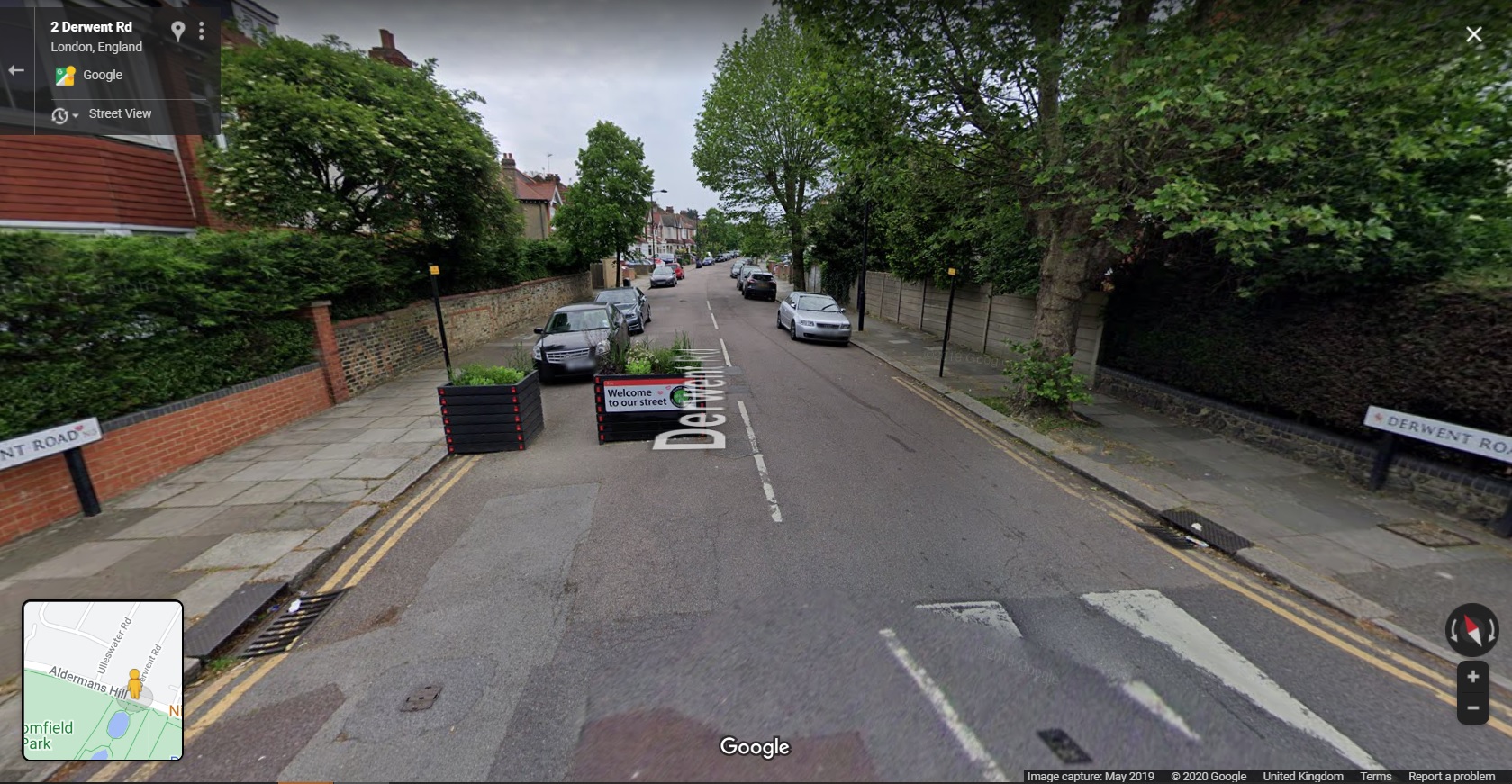
I crossed the A406 North Circular onto Powys Lane and then into Broomfield Park. At the north side of the park, I needed to cross Alderman's Hill which was awkward given the lack of dropped kerbs. Still, I crossed and entered Derwent Road which is part of the Fox Lane Quieter Neighbourhood Scheme.
This scheme is interesting because it has been a work in progress for some time - back to 2017 when you read through the information on the council's website. The initial scheme for the area relied mainly on traffic calming to deal with speeding and rat-running. From what I can work out (and correct me if I am wrong) the scheme started in late 2018 and further work took place in early 2019 - the proposals are shown on the plan below taken from the council's website;

One of the key features was to use planters on the junction entrances to and within the area to discourage drivers from entering because they would have to give way to drivers leaving the area - that idea can be seen in Google Streetview;
There were other proposals such as speed humps on Fox Lane (which runs east-west through the area). I didn't know anything about the history when I visited and so it is only now that I am seeing what happened.
Some of the planters were deployed in late 2018 and feedback ranged from residents saying they were working to residents saying that drivers were going faster past them. By the summer of 2019, additional planters had been deployed to the same arrangement. The results from monitoring showed that there had no effect on the volumes of through-traffic and so the scheme was to be removed and further ideas developed).
In the Autumn of 2019, the council announced that it had been working on other proposals which would shortly go forward as an experimental scheme to give people a chance to give feedback on a live scheme. There was a period of consultation prior to the experimental scheme which was extended to the end of 2019. Changes were made to the proposals and eventually the scheme went live in September 2020 and is now in the consultation period;

The plan from the council's website above is a little hard to see, but essentially it shows a series of modal filters (planters and bollards) mainly on the junctions to the south of Fox Lane with a couple of camera-enforced filters for emergency access use. The area is also subject to a 20mph speed limit and the red line you can see is a bus route which is maintained.

A planter/ bollard combination, Derwent Road.
It's worth having a look at the link above because there is all sorts of interesting traffic modeling analysis supporting the experiment. For example the "before" traffic flows for Fox Lane for 7am to 7pm were 9,000 - 10,000 vehicles per day with the predicted "after" being 10% of that. The modelling does of course predict higher flows on the boundary roads (this will settle down with time), but it's interesting to see that modelling has taken place in this case.
As ever, this may well be the controversial part of the scheme - hopefully there will be further traffic information gathered to see what actually happened and then maybe some longer term monitoring as Enfield suggests that there is a much longer term programme for the borough.

One of the camera-enforced filters towards the
eastern end of Fox Lane, near the A105 Green Lanes.
There has been a great deal of design and engagement work to get this far. It would be very easy for me to point out the fact that the planters at the junctions idea without filtering was doomed to fail (I'm confident in stating that), however, people need to find their own way. The value of having this ongoing live project is that the data generated very clearly showed the public and politicians that a light-touch approach doesn't work and so provides immediate feedback to the community.
This is also interesting because as one of the three Mini-Holland boroughs, Enfield had tried to get change by concentrating on building cycle routes on a couple of corridors through the borough without tackling the side streets, whereas international experience shows we need to crack on and tackle everything. The other interesting thing is because Enfield did try and tackle some main roads first, it rather confronts the assertion from those against low traffic neighbourhoods that you have to deal with the main roads first because now the borough is seriously looking at the side streets!
My journey continued into Fox Lane itself where I headed east towards the A105 Green Lanes (Cycleway C20), through the camera-enforced filter in the photograph above and then with a left turn into the A105 Green Lanes itself. This scheme has created protected cycleways from near the Haringey border in the south (with a quieter link to a crossing of the A406 North Circular Road) and just short of Enfield town centre in the north along the A105 corridor - around 5.2km. All on the western side of the A10.

I was aware of the general model that Enfield had adopted which was light protection along the links with full protection at points of conflict such as junctions, bus stops and within some of the local centres.
As I entered Green Lanes, I saw that the original light protection of wands and orcas (full-sized and mini) had been changed to bolt-down rubber kerbs with wands (photograph above). This follows a review of the scheme and the availability of more options for light protection becoming available on the market. Certainly, the new arrangement using Cycleway Defenders (by Rosehill) is much more conspicuous than the previous materials;

These 2 metre long units weigh in at 60kg each and are made of recycled tyre rubber, completely solid and bolted to the road surface. Personally, I want full-on kerbs and buffer protected cycle tracks everywhere cycle tracks are needed, but pragmatically, this is something that will take generations to get. It's also a challenge in a situation like Green Lanes where there are so many private driveways, you would have to essentially reconstruct everything. This unit comes in three styles (end, double end or intermediate) and so you can have continuous runs if that's your need.

The original light protection has also been changed for bolt-down rubber units by the car parking spaces along the route - this time the "Lane Delineator" product, also by Rosehill, has been used (photograph above). These units are 1.5m long by 0.5m wide and weigh in at between 95kg and 105kg depending on the type of unit selected (three options again). Being 0.5m wide, this product gives the desirable minimum buffer from traffic set out in LTN1/20 - personally I would always want to see more of a buffer, but this is pretty good. There of course may be issues here with some drivers or passengers being unable to cross the kerbline - maybe there needs to be a review to provide some accessible spaces.
Again, the units are bolted down and can be quickly deployed to give a permanent run of kerb protection to a cycle track. Here is the product being installed in Enfield;
I really like this unit because it's heavy and looks the part from a driver's point of view (more so than the narrow unit). Where an existing road is wide enough for an in-carriageway retrofit scheme, this is a much easier unit to install than concrete products which may require a recess to be formed in the surfacing and reinstatement afterwards (other than stick-down composite units). There is a little flex to take in the longitudinal profile of the road and drainage is maintained by having regular gaps.

The one disadvantage (in common with the various concrete competition) is that the units are high at 130mm. This means there remains a risk of pedal strike on the offside of a cyclist which does reduce the effective cycle track width. The Dutch CROW Manual suggests that at over 50mm, maybe 500mm of effective width is lost whereas the UK LTN1/20 suggests 200mm. Coupled with the existing nearside kerb, designers do need to factor this in.
In addition, a carriageway-level cycle track with raised protection is also going to make it harder for people to cross the road which is something else for the designer to take into consideration (regardless of material choice) - of course regular gaps can be easily provided without any real loss of protection for people cycling.
Away from the protection choices on the links, Enfield has rolled out a standard treatment at many side streets which I fear may need to be retrofitted in the future (below);

The approach builds out the footway at junctions to provide a buffer between traffic on the main road and the cycle track, the idea being that drivers turning into a side road have a bit of space to allow people cycling to pass. Drivers emerging from the side road are invited to give way at the point where pedestrians cross. Cycle priority is also reinforced by the use of elephant's feet markings.
Unfortunately (and in common with Waltham Forest), the elephant's feet are used unlawfully. They are reserved to guide cycle traffic through signalised junctions where there is a cycle green stage or within parallel zebra crossings. There will have been decisions taken on the risk of departing from the correct use of the markings, but unlike Waltham Forest (photograph below), Enfield has not provided continuity of the footway or cycle track over the side road. As a cyclist, you also end up having to bump up and down some of the kerbs at the junction where kerbs haven't been quite laid flush - such connections should have been made with asphalt to asphalt.


The photograph below is at the junction of Green Lanes/ Bourne Hill / Hedge Lane. It shows the generality of the materials choices for the A105 route with lightly coloured footway materials and a buff asphalt cycle track (which I'll come back to shortly).

There are only cycle signals on the A105 arms of the junction - from the side roads, people will need to mix with traffic to access the main road cycle tracks. Cycle traffic can turn left or right from the cycle tracks into the side roads - the main issue with the arrangement is that there are no green men to help pedestrians to cross and this is a function of an attempt to maintain motor traffic capacity.

One thing which I did quite like was the choice of materials for the fully protected areas. There's generally light coloured footway paving, a triple row of square granite setts and a buff asphalt cycle track (above). The granite setts perform a demarcation function - I'm not sure how useful they are for visually impaired people, but they seem to do a reasonable and not unattractive job - they're also OK to cycle over if you need to leave the cycle track. The asphalt gets it's colour from the binder coating the pieces of aggregate, but as it's only cycle traffic using it, the colour should last well (below).

The actual feel of the landscaping at key points is rather Scandinavian - the photograph below is from Malmö in Sweden and you can see the light colours and triple row of granite setts for a footway level cycle track.

The other detail to note is the bus stop treatments. In some cases the designers went with bus stop boarder type layouts where the bus stop boarding area is essentially shared with people cycling (below);

There are some locations where the provision of a cycle track/ protected lane on each side of the street has reduced the carriageway width to a reasonable operational minimum for an A-road, but there are other places such as the location above where it looks like some extra space has been left to try and make it a bit easier for drivers to overtake a stationary bus and there are places where car parking is maintained on the opposite side. That being stated, we have consistency of treatment at the stops, but there is potential conflict built into the layout.

Any shared area at the bus stops has a consistent treatment of dark paving with lighter strips across the line of travel with paved cycle logos in the centre - in a few cases, the logo paviours were moving and unless remedied, they'll become a safety risk.
Bus stop boarders are a legitimate tool where space absolutely requires them where passenger use is low and maybe without really high cycle flows. In general, I didn't experience a great deal of conflict (maybe interaction is a more accurate word) and perhaps the consistent design approach helped. The paving itself is generally smooth, but it will never be as good as a machine-laid surface. However, by far the worst thing about the bus stops is the steepness of the ramps between the carriageway and the shared area.
The constant bumping up and down coupled with the vibration from the block paving was irritating at first and exhausting by the end of my tour, especially cycling uphill. These ramps really need to be twice as long and more sinusoidal in profile. This floating bus stop at Winchmore Hill was much better to cycle past.


The layout of the junction is largely the same as it was prior to the Mini-Holland scheme, but it has been tweaked to get rid of staggered pedestrian crossings the on Bush Hill Road and Church Street arms. The junction did have green men pedestrian crossings in all directions previously, but they have all been changed to toucan crossings.
Unfortunately, if you are passing through the junction on the A105 route, it is the toucan crossings you have to use. Heading north, you cross Bush Hill Street in one stage, but heading south, you have to cross Church Street in two stages because a left turn slip road from Church Street into Ridge Avenue has been retained.

The photograph above shows a sign on the southbound route through the junction. You can see the two stage toucan crossing heading south on C20 (keeping on the A105). The left turn onto C21 (Church Street) links to a two-way cycle track which in turn links to some quieter streets.
Within the centre of the junction, there is a pair of diagonal cycle crossings which you can see in the junction and sign photograph. If you are heading to Bush Hill Road, rather confusingly you have to use two toucan crossings rather than the diagonal crossing which would have made far more sense (and you have to use the pedestrian dropped kerb to get into Bush Hill Road).
Using the diagonal crossing would allow access to the service road on the western side of the junction to then head north, although I can see drivers using the service road to turn left to avoid the signals.

I've tried to show how this all works on the image above. The red, orange and purple lines are the "official" routes through the junction and the blue route is my suggestion of using the diagonal cycle crossing and the service road to get to Bush Hill Road.
When I cycled through northbound, I was expecting to use the diagonal cycle crossing (there is no northbound sign to help), but I realised this was wrong and so I swerved into the toucan crossing at the last second (you'll see this in my video of the route). Luckily the four toucans in the junction run at once along with the pair of diagonal cycle crossings, so I was safe.
The junction is, I'm afraid a little bit smoke and mirrors. It may have lost the staggered side road crossings and gained an all-round green for walking and cycling, but it is still arranged around motor traffic flow, hence the toucans and shared areas. I'll drop back to what happens on Church Street next week and continue heading north towards Enfield.
At the junction of the A105 Park Avenue with Bush Hill (below), we have the usual protected approach to the junction, although the actual cycle crossing in this case uses a pair of give ways for drivers with the cycle track bent out from the main road. This is a perfectly lawful layout, but although the junction has been tightened up, the right turn for drivers in to the side road remains easy and I saw a couple of people go round fairly quickly.

As we get near to Enfield town centre, the protection which has been in place ends and you're dropped into a part time bus lane 300m short of the town centre, although in fact you soon turn off into Essex Road into a lightly protected contraflow cycle lane which eventually takes you to the edge of the town centre by another route. This is disappointing really because it doesn't exactly welcome you to the borough's main town. Not that you would want to carry on cycling north because there's a nasty gyratory ahead.
One other little thing to look at this week. Turning out of Essex Road to head south, you cross the A105 London Road (finding a gap in traffic) to a cycle track. This has been created from an old service road which was pretty grotty. The car parking has been retained, but now it protects a buffered cycle track with a nice rain garden and some tree planting;

Despite the problems I have highlighted, I really like this scheme. A huge amount has been achieved over quite a long distance (in a large Outer London borough). The retrofit of better protection on the links shows the Borough is up for improvement and so I hope they can go and take another look at the side road junctions, maybe some of the bus stops and perhaps providing a few more green men at the signalised junctions. The decision to invest more at points of conflict is a really pragmatic solution and of course, maintenance budgets could be aligned with scheme budgets to improve things further.
The fact that we have a longer distance cycle route with a Low Traffic Neighbourhood feeding it means that Enfield is starting to discover how this stuff works at a network level which is as exciting as seeing some great things being built.
Next week's post will stay with Enfield as I head over to a parallel cycle route to the eastern side of the A10, but I shall leave you with a video of C20.
Curious as to why the rubber blocks the wands are sitting in are installed inside the white line and not on the white line. What the logic?
ReplyDeleteIt's essentially because there is still a mandatory cycle lane there and if the blocks were on the line, it would look dotted and so may be mistaking as an advisory lane which can be driven in. Of course, with a continuous run of blocks (even with small drainage gaps) you wouldn't need a marking.
Delete