Thursday, 25 March 2021

#LDN Cycle Safari: Barking Riverside

As I continue to get my lockdown exercise within a sensible cycling round trip of home, my options are becoming somewhat exhausted. However, I realised there was a relatively new development I hadn't had a nose around and it was as good a reason as any to get out in the fresh air.

So, I wound my way through the hostile streets of Outer London (east) down to the A13 in search of something a little different at Barking Riverside. The area is part of the post industrial Thames Gateway which loosely covers both sides of the Thames from the edge of Central London out to the Thames Estuary. There have been a variety of development models and attempts to regenerate areas; the fortunes of which have ebbed and flowed with the tides.

The area covers the area roughly between the River Roding in the west and The Gores (another water course) to the east. It's hard to pin down exactly what is going on given the mish mash of old industrial land, existing businesses and housing which charts the areas history from marshes at the end of the 19th Century to modern times. The area continues to develop and redevelop with a new residential area under construction towards the eastern side of the site. 

My visit took me to the central area between River Road and Thames Road, a newer development bounded by industrial areas to the north and west, a declining industrial area to the south (flanking the Thames) and a part of the old Barking Power Station complex to the east. This phase of development is known as "Rivergate" on the site masterplan with other areas at different states of construction.


The photograph above was taken on Renwick Road showing a huge electricity transformer complex. The development I sought was behind this to the west. As you'll see on the video which goes with this post, Renwick Road is a very hostile place to cycle.

Renwick Road becomes River Road (forming a long loop which meets the A13 at each end). I turned right off Rover Road into Handley Page Road into one part of the more modern development.


The photograph above shows the Handley Page Road with a toucan crossing just out of shot. A little further up and walking and cycling get their own space. For cycling this is good because you can avoid the buses which help connect the site to the outside world.


There is plenty of space for everyone (above) and the 3.5 metre wide cycle track feels generous, but at this end of the site, it doesn't really connect to anything, so I assume it will feed into developments replacing the open storage along the Thames to the south. There's also a nice buffer for sustainable drainage.


The cycle track is reasonably smooth and in this part of the world, green is the chosen colour (above). There is no tactile or vertical separation between the cycle track and footway which is disappointing given the site has been developed within the last ten years. The development is still under private control, a fact given away by the private parking signs and patrolling security guards. 


Unfortunately there didn't seem to be much control at the "village square" in the middle of the development where walking and cycling is ostensibly mixed, expect it's made all the more difficult by the car parking free-for all on both sides of the street (above and below).


The other big issue with the layout is the junctions. The separation ends and people walking and cycling have to mix again and indeed give way to motor vehicles (below). Here I wanted to turn right into Minter Road because I was running out of development.


I crossed over and then saw the same kind of layout in Minter Road (below). It just demonstrates that links are easy to design, but junctions need thought and no thought had been given here to prioritise walking and cycling.


Minter Road does have a great feel about it. There is a wetland area with a more formal lake at one end which I assume is all about drainage attenuation, plus it's under electricity pylons where there will be a restriction on building in any case. Apart from the cycle tracks not actiually connecting to a proper network, the main problem with the two-way cycle tracks in the development is residents living on the opposite side of the street don't have any easy way to access them.


There's actually some interesting modern architecture in the development which is in complete contrast to the existing housing stock which is very late 20th Century box-shifter style (below).


Minter Road meets with Mallards Road with an attempt to carry the cycle track through on the main loop (above). It doesn't work well because drivers see a fairly traditional layout with people walking and cycling perhaps assuming priority. The main loop heads back round to Handley Page Road and so we see a triangle spine loop within this part of the development.

Mallards Drive is an older street and there are no cycle tracks so people cycling are back on the carriageway and now mixing with the buses which serve the heart of the wider development. There could have been an extended cycling network being new build, but for some reason it was forgotten. Just off Mallards Drive is Drake Close/ Harlequin Close, a mix of flats, houses and town houses (below).


The dwellings surround a central open space with some fronting and some having back yards/ gardens opening onto it. Again, the open space also provides drainage attenuation. One thing which struck me was the attempt to use the car parking as traffic calming; with the block-paved carriageway and the square it really felt quite Dutch/ Scandinavian.

Sadly, the demands of parking cars everywhere has taken over the good design and rather than maintaining the staggered and subtly laid out parking spaces, the white paint has just stuck them all on one side of the street. In the photograph below, you can see the original parking bay on the right had side of the street in the distance which would have created a stagger with the one in the foreground.


I then carried on up to Galleons Drive with the older late 20th Century housing on one side and the new on the other. The original footway has been designated as a shared-use path, but I stayed on the carriageway and headed west over a watercourse to another section of newer development. 

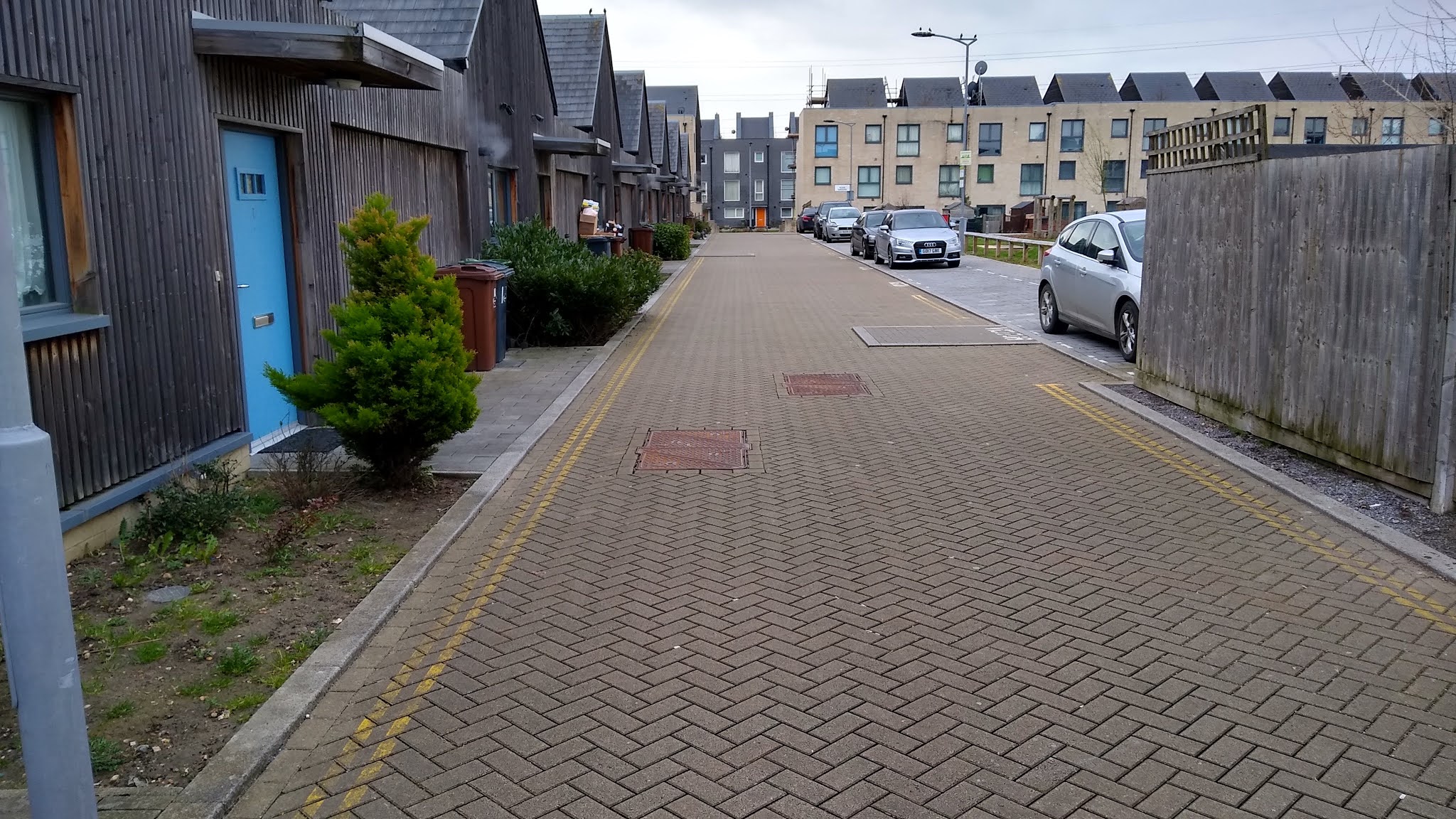
The separate footway and cycle track model reappeared on Galleons Drive, although the cycle track was a bit narrower than before and someone had forgotten to mark it as two-way.


At the side streets the designers give priority to motors again. The photograph above is the entrance into McAllister Grove which is a small access road forming part of a network of residential streets. There has been an attempt to differentiate the walking and cycling sides at the junction, but with a shared area as a landing to an informal crossing point and a second junction in the distance, we have death by tactile paving and instead of "tram and ladder" style, we have corduroy. It's a total mess.


One thing which was almost done well was some of the car parking along Galleons Drive. It's echelon style with the angle arranged so most drivers would reverse into the space. This means that as they leave the space, they have a decent view of what's happening around them. Unfortunately, some of the bays abut the cycle track leaving vehicles overhanging.


The photograph above is another open space/ drainage attenuation feature between McAllister Grove and Middleton Grove. The housing here includes some single storey dwellings (below) and there are other open space areas, but behind the dwellings with the same private space opening out onto them as I mentioned earlier.


The street layout is pretty compact with the roads design to provide access rather than car parking (below). Although the kerbs to the footways are low, the designers unforgivably forgot to drop them where people need to cross the road.


The original intention appears to have been having mainly off-street car parking (some cleverly hidden within the private curtilages with a bit of on-street provision designed in to the layout. Unfortunately, this has been abandoned in favour of marking out lots of new spaces on one of the footways (Lawes Way, below). This leaves no space to get passed.


Over on the western extent of this phase of the development we have Crossness Road (below) which is a very wide street, yet cycling is given some intermittent paint and you can see some of the parking issues spilling out on the right hand footway.


The northern end of Crossness Road joins the Thames Road industrial area and the south is still under development.

I really tried hard to like what I saw on this little trip and to be sure, there are some nice features and even a half reasonable attempt to try and sort out a street hierarchy. Sadly, though, there are too many mistakes and compromises at both the planning and detail ends of the scale. 

One of the most significant issues is the poor connectivity to the rest of the world. The site has a Public Transport Accessibility Level (PTAL) of mainly 1a/ 1b with some areas of 2. This is what suburban London has which means the use of private cars will still be important or necessary to some residents. There is an extension to the London Overground being built at the moment to the east of Renwick Road which will allow interchange at Barking. 

However, the area is still relatively isolated because of natural and man-made barriers and coupled with the hostility of Renwick Road and River Road, cycling isn't going to be an option, especially with the lack of coherent local network. Sadly, the UK seems to suffer from a malaise of building car-centric developments. Even where public transport is planned, unless it is open and operating for the very first person to move in, the use of the private car is being baked in from day one. 

The other thing to note is that the there were also lots of existing residents and businesses in the area who were forgotten about with transport and their existing travel habits will be tough to change. Frankly, there needs to be a detailed walking and cycling review of the area with investment into making proper changes, including better crossings of the A13/ rail corridor to the north. I shall leave you this week with a video of my spin around the area.


Thursday, 18 March 2021

Designed In Risk

One of the staples of the modern media click bait outrage manufactured culture war is the one where a video is shown ostensibly of a "cyclist" doing something "wrong"; often pivoting to a "who was in the wrong" debate.

It must have some positive effect for the organs that spout this claptrap - and by positive, I mean revenue, otherwise why do it? Maybe it really is a culture war, maybe just clicks for ad payments - who really knows or indeed cares; it is a cultural product of ignorance, indifference and mendacity often displayed by the UK media on many subjects.

What is pretty much never discussed is the environment; the design of the highway space, or how the local authority has decided to treat people (regardless of their chosen mode) either through design or more likely, the gradual creep of bad ideas. This week, I am going to have a delve into a couple of click-bait videos and look at them from a Sustainable Safety point of view.

The first video features at the start of a report by ITV into the introduction of London's Safer Lorry Scheme by the Mayor of London which includes the direct vision standard. The actual video is probably a few years old, but thanks to someone having a Strong Opinion on cyclist behaviour, it was tweeted out and you can have a watch of it here and below;


The video shows a group of people cycling away from some traffic signals in a "turn left" lane with a lorry driver moving ahead in what we assume is an "ahead" lane. All of the cyclists get away from the stop line before the lorry driver, but a couple of them appear to be in the lorry driver's blind spot created by the design of the vehicle.

Start of the video - YouTube/ Simon Burrell

Very shortly, the people cycling have moved right (because of the road alignment) and the lorry driver apparently doesn't see what is happening on their nearside and hits one of the cyclists who does a very good job of keeping upright, the lorry driver immediately stops and all concerned come out of the incident intact - although the video goes on to show a verbal altercation between the cyclist and the lorry driver. 

The driver tells the cyclist that he should know not to go up the inside of an articulated vehicle because that's what is in the adverts and the cyclist tells the lorry driver that he should expect people to be on his inside because that's what happens in London.

The incident - YouTube/ Simon Burrell

So who was in the wrong? Well, I'm going to suggest both people in the incident maybe bear some responsibility (rather than blame), the driver's employer bears some responsibility (because of the choice of vehicle and maybe driver training), the lorry manufacturer has some blame for sticking with such a poor design, but most of the "blame" can be apportioned to the highway authority. Not because of any premeditated negligence, more about years of indifference or lack of funding priority for stuff like this which applies to pretty much every highway authority in the land.

We know this incident was in London because of what is said in the video, but because we can see a large river on the right, we know it's next to the Thames and in fact it's the A3220 Cheyne Walk on the eastbound approach to the junction with the Battersea Bridge. The approach in question looks like this;

A good view from 2017

Just before the view in the image above, the road is single carriageway, it flares out to 3 lanes over a short distance with 2 ahead lanes (right turns onto the bridge being banned during the day with a variable signal) and a short left turn lane of about 10 metres long where the lane is marked. The road returns to a single carriageway soon after the junction, although it's a bit wider this side.

For westbound traffic, there is a similar arrangement of three lanes with right turns banned all the time. Traffic leaving the bridge can perform all movements and traffic on Beaufort Street heading south cannot turn right. People on foot get no green man and so this is very much about shifting motor traffic.


In 2008 the layout is a touch different (above) because the left turn would have taken drivers into the Western Congestion Charging Zone and so the markings hint at the need to make a more conscious movement into that lane. Maybe if that marking had been retained, people cycling may have "taken the lane" a bit more.

So, why were the cyclists up the inside of the lorry, despite what the adverts say? The very short left turn is barely usable for drivers because there will undoubtedly be plenty of queues here at peak times. It's a busy cycle corridor and so an open piece of tarmac to get ahead of the traffic is attractive. People maybe don't think about the risk, maybe the adrenaline is pumping because of the conditions and maybe they haven't seen any adverts.

The lorry driver should have had some awareness of the cycles to his nearside. Maybe he didn't check his mirrors enough (there is a downward facing nearside mirror above the passenger door), but it's hard work driving a lorry on roads like this and it's a high level of tasking for anyone to be able to see what is happening at all times from such a vehicle. Maybe the driver's employer should have invested in a direct vision vehicle and maybe the manufacturer should have stopped making lorries like this decades ago.

From a Sustainable Safety point of view, there are some points to think about;
  • We shouldn't be mixing traffic with significant speed differentials
  • We shouldn't be mixing cyclists with traffic at 30mph
  • We shouldn't be mixing cyclists with high volumes of traffic
  • We shouldn't be mixing cyclists with HGVs
  • We shouldn't be providing road layouts which kill people if any party makes an error
So, would dropping the speed limit to 20mph help? Yes, that would assist to a limited extent on a link (the road away from a junction), but it wouldn't deal with conflicts of the kind we see in the video. Even at 20mph, we are are still mixing people with high traffic volumes and we'll still have HGVs on a road like this, although the direct vision standard makes it much easier for lorry drivers to see what is happening on their nearside.

A direct vision lorry with good nearside and forward visibility

What about education? We can tell people to be careful until we are blue in the face. Some will take heed and remember, some will not be exposed to the education and some won't be bothered. People will still make mistakes.

The solution for this junction is to separate people cycling from traffic. It may be that either side of the junction, basic protection does a reasonable job, but people need to be separated in time and space within the junction. I have had a quick look at the CycleStreets collision data tool which gives some startling, but maybe unsurprising results. Between 2005 and 2019, there were 128 recorded injury collisions in the immediate vicinity of the junction. 17 involved death (1) and serious injury (16), with 4 involving cyclists, 7 powered two wheelers, 2 involving pedestrians and 4 involving a car occupant.

With the slight injuries (111), 28% were cyclists, 26% powered two wheeler riders/ passengers, 8% pedestrians. The remaining 38% was pretty much car occupants. It's a junction which doesn't work for anyone in absolute safety terms based on collisions and those outside of cars come off worst. I haven't done any more analysis (this is not my day job), but the junction screams out for action.

There would be lots of different ways to protect people cycling and it would need to be implemented at a network level with motor traffic capacity would have to be given over to other modes. From a cycling point of view, banning general traffic from turning left into Beaufort Street and onto Battersea Bridge and a permanent ban for the right turn onto the bridge would allow cycle traffic to run with general traffic in protected space. Having a slightly set back pedestrian crossing point could also run at the same time with left turning cyclists being held. Right turns for cycling could be provided as two-stage turns.


The image above is a rough sketch. There are other options and ideas, but this to me is something which could be delivered using bolt-down islands and traffic signal works - offered without detailed thought on actual staging and the network level changes needed to perhaps mitigate the banned turns for general traffic. This would provide protection fairly quickly compared with a total rebuild. It's also worth mentioning that emergency services vehicles could of course ignore the banned turns if required.

There is some work planned by TfL at the junction, announced at the beginning of this year. The immediate works are to help pedestrians with a new signalised crossing on the north end of Battersea Bridge along with a permanent right turn ban onto the bridge. This comes after the death of a jogger earlier this year - it's the natural place to add a crossing given people will want to be on the river side. Later this year, there will be further consultation on crossings on Cheyne Walk (which says 2-stage to me) and another over Beaufort Street. There is no indication of works to protect people cycling as yet.

*****

The second video I want to have a look at involves a cyclist turning right across a traffic lane and bus lane and being hit (I think) by a taxi driver using the bus lane. I don't know if the person who posted it was the taxi driver and I can't find a YouTube link, but here are a couple of stills from the video posted by Coltscabs on Twitter;


The video starts with (I assume) taxi driver moving along the bus lane, undertaking a slower moving general traffic lane (above). The Transit-style van in front of the black car has just come to a halt at the keep clear markings.


The taxi driver continues at the same speed and as they draw level with the van, we see the cyclist on the London hire cycle turning right. The taxi driver doesn't brake until the last moment and hits the cyclist. It's only a short video, but the cyclist gets up and at least appears unharmed. We don't know what happened next, although in response to the post, it's pretty much a stream of abuse towards the cyclist.

Again, we can find the location easily. It's the A3 Clapham High Street at the junction with Gauden Road and the blue paint is CS7. Here's a better view of the location from November last year;


The restaurant on the corner to the left of the bus is boarded up in this image and so therefore, I assume it's very recent. The speed limit here is 20mph and so with a half decent level of compliance, it makes crashes more survivable. By my calculations, the taxi driver was travelling at about 17mph which was good news (relatively) for the cyclist.

So again, we're invited to opine "who's at fault"? Maybe the van driver in slow moving traffic was being polite and left a gap for the cyclist to turn into, only to be collected by the taxi driver. Maybe the cyclist took a chance and expected the bus lane to be empty because they saw no bus. Maybe the taxi driver should have been far more alert when moving faster than general traffic with an expectation that people might turn right.

Going back to the Sustainable Safety approach, we have a 20mph speed limit and for people cycling in the opposite direction there is a bit of mandatory cycle lane (which I think has some wands). The bus lane itself is a bit of protection for cycling, but there could just as easily be right turning vehicles and a bus lane-using cyclist colliding. The layout has been around for about a decade and was one of former Mayor Johnson's awful paint'n'signs attempts at cycling infrastructure.

It's hard to see without the raw data, but again, using CycleStreets, there is a cluster of injury collisions around this junction with maybe 60% involving cyclists being hurt. The problems with a layout like this from a cycling point of view is that there isn't a safe place to turn right from. You can't do it from the mandatory lane because of following traffic, so you have to take the lane, you then have to find a gap in two streams of traffic and in a busy situation, you may not be able to see that second (bus) lane.

It's not just this location, it's a common layout all over the place and so the risk exists at every side street. As well as creating lots of risk to people cycling, it's also a high cognitive load for drivers. The solution here is not easy because the bus lane is clearly something to give bus travel an advantage and we have the classic UK problem of stuffing A-road traffic through a local centre.


The image above is roughly the arrangement now (21m or so wide) and so in theory there's space to do lots of different things, but priorities are going to be tough to deal with. 


The option above removes the bus lane and introduces a central median which would be broken at side streets. The buffer between the carriageway and cycle track would essentially be entrance kerbs at side roads and so a right turning cyclist could could pull to the right hand edge of the cycle track (with other cyclists undertaking). When there's a gap in traffic, they can cross to the "shadow" of the median strip and then when there is a gap in the next traffic lane, they complete the turn.

Drivers would also be able to turn into the median gap to make the turn in two parts. Right turns from the side road would be similar. Of course, side streets could also be filtered to reduce the conflicts.


The option above retains the bus lane, but the cycle tracks are a little narrower and the footways are reduced. In this case, right turns from the cycle track would be physically prevented/ discouraged, as would general traffic turning right across the bus lane. General traffic would have to go a different way (probably via a signalised junction into a filtered area) and cyclists wishing to turn right would also be taken a different way (as part of a planned network) or they would U-turn using a signalised or parallel zebra crossing.

This crossing on Lea Bridge Road, Waltham Forest gives cyclists right turning opportunities with a small detour, but avoiding having to cross two lanes of traffic.

In many ways, this is more difficult a problem to solve than Battersea Bridge because it is a street and network issue rather than a junction and maybe network issue.

*****

So, the point of this post is what? First, it's to show that unless someone is really behaving badly, most of the conflict we see on our streets can be traced back to the street design, whether deliberate or not. It shows that people make mistakes and it invites us to consider the question about whether we really do think it is appropriate to think someone should be killed or injured because of human errors.

It also serves to hold the click-bait media to task because they want to boil everything down to a two-side culture war which doesn't serve society or the public good. If they spent more time asking difficult questions of decision makers and those with power to effect change, then maybe we'd see a better public discourse and less noisy extremism. 

This post also serves to remind us that many of the challenges we have is because of the reluctance to tackle motor traffic dominance in our towns and cities. Once we remove the shackle of "traffic neutral", then we have so much more flexibility.

Saturday, 13 March 2021

Turn It On Its Head

Imagine planning and operating the streets network where the presumption is that driving and car parking is banned and every change has to go through a statutory and consultative process.

Streets would be for walking and cycling only from day one and any moves to change this arrangement would be subject to the local highway authority having to public a traffic order proposing the change to the status quo, people would have a statutory right to object in writing. Parking will only take place in marked bays, driving will be at walking pace, unless there has been proper consideration of allowing greater speeds.


Depending on the type of traffic order, there would be specific national statutory consultees. For example, we'd have to have the views of the emergency services taken into account, but perhaps we should also include the Cycling Marketing Board and the European Cycle Logistics Federation to represent industry views, Living Streets to make sure the view of people walking are taken into account. Of course, we should be ensuring that Cycling UK and local cycling groups (where they exist) are included by default.

If someone wanted to introduce parking in their street, they would have to get some buy-in from local councillors. Depending on the authority and it's constitution, this might require a petition where it will only be taken forward if there is a majority. It might be that local area committees have discretionary funds to take requests forward. 

Once the parking request has been made a priority then it will have to be designed and a traffic order advertised with at least 21 days for people to respond. Once people have responded, the request would need to go to the highways committee for debate, although sometimes the decision would be deferred for more information to be gathered. In some cases, we might need to constrain the width of the parking bay to 1.5 metres. Yes there will be people who will want to park their SUV there, but sorry, compromises have to be made.


For general improvements to the motoring network, local authorities would need to bid for funds through their Local Transport Plan and in some cases, they would need to get match funding from the local combined authority or national government. Of course, we would have to allocate budgets within short political horizons and require bids between authorities who all have needs because there's no way we can fund everything. What this does mean, unfortunately is that before we can provide that bridge over the river for motorists, we need to undertake a programme of encouragement to get numbers up before it can be considered.


For readers in England, the Westminster government will be setting up a new body called "Cycleways England". It will be responsible for improving the National Cycle Network and billions of pounds will be made available for infrastructure delivery. Cycleways England will also be responsible for developing the Design Manual for Cycle Tracks and Bridges. The DMCTB will have a special design standard on separated motoring infrastructure, but in practice, they'll tend to plump for another standard which requires drivers to share with trains. In some circumstances, new shared-use railways will need staggered barriers to help slow drivers down before they meet a cycle track.


Back in local communities, one very controversial issue will be that of the Experimental Traffic Order Process. It's something which has been used for decades, especially in the 70s and 80s where we opened up whole areas to rat-running. These days, motoring campaigners call them "high traffic neighbourhoods" and while naming them as a "thing" can be counter-productive some, of the least progressive councils have embraced them. Of course, as a response to Covid, some local authorities did rip out pop-up motoring lanes because they were destroying local businesses. We'll probably look back on all of this and smile at the days when walking and cycling campaigners paraded through Leytonstone to stop the M12 being built along Francis Road.


OK, I'm being facetious, but the generality of what I have written is very much how modern highway management has evolved legislatively, culturally and politically. We "have a motor traffic first" presumption and changing it requires time, effort and money. On traffic orders, we have given statutory voices to freight trade bodies and some local authorities have created all sorts of hoops for people to jump through when they ask for change.

As we continue to get push back from politicians, lobby groups, trade bodies and those with a vested interest in the status quo, it might be useful to pause for a moment and remind that they are coming at this from a position of embedded power.

Sunday, 7 March 2021

Voorrangsplein! Part 2

Last week, I wrote about the Dutch voorrangsplein or "priority square" junction and how it could make priority junctions safer for drivers in a UK context. This week, I am going to look at walking and cycling within these junctions, maybe a UK example and some further reading.

In many ways, this probably the easier part to talk about. Voorrangspleinen (I think I have the plural) are not walking and cycling infrastructure, they exist to prioritise motor traffic on the main road, but to also provide protection for people turning right to and from the main road (Dutch left). 

The important consideration for walking and cycling is we should be considering them on their own terms and providing them with their own legible networks. Sometimes they will coincide with main roads in terms of crossings and parallel movements and in some places and contexts this coincidence will be more common. 

I left you with an example in Langedijk last week. I picked this for no other reason than came across it in doing some internet research for this subject, but it's a good one to look at for walking and cycling. At the network level, the area is bypassed by regional roads, but there are some distributor style main roads within the settlement such as Westelijke Randweg which is the main road on which the voorrangsplein is constructed;


In fact, there is a second voorrangsplein on the same road just to the north and the next junctions either side are roundabouts. It's worth having a nose around because you'll find that this main road has a separate two-way cycle track forming a wider spine for cycling. The road itself is subject to the built up area speed limit of 50km/h (30mph). Sustainable Safety demands that we don't mix cycling with 50km/h traffic, something almost unheard of in the UK.

If you have a look around the area, you can see that there is lots of commercial and residential development going on because you'll also find the old road layout. Our junction provides a connection to Klaversloot to the east leading to a residential area. The speed limit there is 30km/h (20mph) and there is no cycling infrastructure. There doesn't need to be, the roads don't go anywhere other than serving the residential area, although the walking and cycling networks permeate beyond where cars can go.

People cycling are not allowed to cycle onto the voorrangsplein, but they don't need to as one of the local streets becomes a cycle track which connects into the spine network. I have circled the location where the cycle ban comes into play in yellow and the location where the road changes to the cycle track in blue (below).


On the western side of the junction, there is access to Grootoort which is another 30km/h area. I can't see if there is a cycling ban from entering the junction here, but I suspect you shouldn't. But from a network point of view, I think you would just join and leave the cycle track as you need to to access the residential development to the west.


As you can see above,, the spine cycle track has priority over Grootoort and is set back from the main road. If this driver wanted to turn left here, they give way to the cycle track, then they give way at the main road (whilst not blocking the cycle track as in the image). They then cross one traffic lane to get into the left turn pocket and then they will find a gap in the main road to head north. Each movement broken down within protected space to give time to think.

The the footway links on both sides of the main road are to access bus stops for each direction only (and there is cycle parking for people cycling in from further afield). People will generally be cycling, but there is a walking network through the estate to the east. People from Grootoort and the west will be crossing the Voorrangsplein and walking through the estate to the east of Klaversloot. In essence, there is a motoring, a cycling and a walking network.

Let's have a look at where the cycle track and footway crosses the voorransplein. At street level you can see how the road is locally dualled with some fairly decent horizontal deflection (below). Drivers have an excellent view of the crossing and its approaches.


The refuge area is about 9 metres wide which will give lots of comfort for people walking and cycling. Crossing the road has been split into two parts. On the right of the image above, the crossing is about 3.5 metres and on the left its's 4.5m (mainly because the widening is offset onto the right). From the other angle, we can see more details;


For walking, there is tactile blister paving near the edge of each crossing point. On the island, there is a central strip of guidance tactile paving to help visually impaired people find the second crossing point (image below). Cycle traffic gives way because through motor traffic is prioritised. In practice, it will almost be certain that gaps are easy to find, even at peak times and so from a cycling point of view, you would watch what is happening and adjust your speed to find a gap in each stream.


The cycle track is paved in concrete slabs rather than smooth asphalt and there is no height difference between the footway and cycle track; both issues means this is not as good as it should be. This example is probably best described as suburban or possibly rural fringe, but the key point to make is the crossing point isn't a feature of the voorrangsplein per se, just that layout lends itself very well for a two-stage crossing which is again, Sustainable Safety in practice.

Let's have a look at a slightly more urban example about 3km to the southeast in Heerhugoward. This voorrangsplein is also on a connector road with a roundabout to the east and a signalised junction to the west. Again, it's worth a look around to see how the the road network has been designed with distributor roads provided access to what are in essence Low Traffic Neighbourhoods. The choice of roundabouts in some locations will be a function of busier side road arms and signals where two distributors intersect. 

In this case, the voorrangsplein provides access to a residential area to the southeast and a mixed development to the northwest which includes a loop road providing bus access to the local railway station;


The main road (Westtangent) has two-way cycle tracks on each side, although at the northwest corner the cycle track goes through a car park! It's the crossings which are of interest again. As before, people walking and cycling give way and the crossing distance is about 3.5m on both crossing points. There's no stepped cycle tracks or pedestrian tactile paving this time which is an issue.


The central island again provides the traffic speed reduction function with the crossings working independently of the voorrangsplein, but in this example, the central footway and cycle track bends a bit to face oncoming traffic. Cycling is one-way only and so there is a one-way cycle track on each side of the junction meaning people cycling orbit the junction anti-clockwise (orbital cycle tracks being a core design feature of protected intersections generally).

Access from the residential estate (which has a 30km/h speed limit) via Jupiterlaan makes drivers turn left into the junction before they turn right using the voorrangsplein, Pedestrians walk where they like and cyclists can choose which side of the main road to cycle on. In practice, you would probably just join the cycle track on this side of the road. Cyclists going across the junction would turn right onto the cycle track and then left to cross the main road. On the other side, there is a service road one way and a cycle track the other on the approach to the junction, with cycle traffic mixed with general traffic a little further in.

Google Streetview has picked up a view of a large truck which has just passed through the junction on the main road and you can clearly see how narrow the lane is which is specifically designed to help keep driver speeds low, despite the prevailing 50km/h speed limit (30mph).


Research for this post (and last weeks) has been a little tricky because it has been a case of Googling voorrangsplein and piecing together what I can find (thank you Google Translate). The concept hasn't really entered the mainstream of Dutch road design. My English copy of "Recommendations for traffic provisions in built up areas" dates from 1998 and the current "Design manual for bicycle traffic" doesn't cover the junction type, possibly because it is a traffic provision rather than a cycling provision.

However, there are a few useful resources. First, Wegenwiki, a Dutch engineering website gives a bit of information and is worth a read. Wegenwiki tells us the first voorrangsplein was built in Hilversum in 2007 and the initial outcomes compared to the previous signalised arrangement were favourable in terms of driver speeds and collision rates and the junction form was included in the 2012 version of Recommendations for traffic provisions in built up areas (not available in English as far as I can see).

Mark Wagenbuur has written about a voorrangsplein in his Bicycle Dutch blog, explaining transformative work in Utrecht where one was installed at a former signalised junction as part of a significant road diet for the city's ring road, t'Goylaan. The interesting variation for this junction is there are signals on the main road some 30m before the junction. When excessive queues are detected in the side roads, main road traffic can be held to allow them to clear (something we can't do in the UK unless it happens to be a standalone pedestrian/ cycle crossing).


Interestingly, the junction I talked about last week at Driemond has signals on each side of the main road. I didn't mention this last week as I wanted to talk about traffic principles, but thanks to someone who contacted me to explain this and the point that the crossings here also allow people to better emerge from the side streets.


I guess the addition of signals starts to erode the point of having a technology-free solution which is what voorrangsplein attempt to provide, but as ever, local context is key. There's a useful article on Verkeersnet giving addition background and making the point that it isn't always easy to cross for cycle traffic, but the use of signals can help (also known as "metering" on the main road).

The municipality of Emmen in the east of the Netherlands has a nice little animation of how a voorrangsplein operates and as far as I can work out is still at the proposal stage for one of the most dangerous junctions in the area on Statenweg.


Finally, there are a couple of research papers which can be downloaded from HBO Kennisbank, but you'd need to be a Dutch speaker or have a bit of time for some translation to access them!

So what of the UK? Have we purposely build any voorrangsplein? In response to last week's post, lots of people made suggestions on Twitter, but nobody found one. Some examples were 2-lane dual carriageways with additional right turn lanes (and a lack of U-turns for right turning traffic) whereas voorrangsplein are 1-lane dual carriageways. Some didn't have the right turn pockets, even if the road was a 1-lane dual carriageway. The only one so far to come close was emailed to me and it's on the A25, near Dorking


It's a very long junction (290 metres between the right turns), but the layout operates as a voorrangsplein. There is a local 40mph speed limit, but in classic UK style, the junction is full of paint and signs (view from the side road);


Drivers are required to turn left and so the movements are being broken down. The give way on the left of the image is a slip road from the main road and whilst it gets left turners out of the traffic flow, this slip road creates a new collision risk with drivers coming from the central reserve.

For those needing to turn right, they turn left and then right into this incredibly long right turn pocket which for my mind is stretching it (literally) from being a true voorrangsplein.


Here's the view on the main road in the other direction where the U-turn enters the main road. It really is dead straight and so lacks the speed-reducing feature which is some 200m before this point (because of an awkward site access);


So, close but no gold star here because there is a significant casualty collision history here which demonstrates that Sustainable Safety hasn't really been applied;


So would I use voorrangspleinen in the UK? Well yes I would, but in the right locations. For the UK, I would give walking and cycling priority because I think it's safer for the contexts, although I might be tempted to use signalised crossings with them.

From an inter-urban point of view, they could definitely help with crossroads layout issues (staggered and non-staggered), but you would need to properly step speed limits down and be very careful to use the right approach geometry to slow drivers. This layout is not appropriate for high speed situations and care is needed throughout the process.

Thanks to all who have provided comments and discussion on this little known junction type and I wonder if we'll get more identified?