
Last week, I wrote about the Dutch voorrangsplein or "priority square" junction and how it could make priority junctions safer for drivers in a UK context. This week, I am going to look at walking and cycling within these junctions, maybe a UK example and some further reading.
In many ways, this probably the easier part to talk about. Voorrangspleinen (I think I have the plural) are not walking and cycling infrastructure, they exist to prioritise motor traffic on the main road, but to also provide protection for people turning right to and from the main road (Dutch left).
The important consideration for walking and cycling is we should be considering them on their own terms and providing them with their own legible networks. Sometimes they will coincide with main roads in terms of crossings and parallel movements and in some places and contexts this coincidence will be more common.
I left you with an example in Langedijk last week. I picked this for no other reason than came across it in doing some internet research for this subject, but it's a good one to look at for walking and cycling. At the network level, the area is bypassed by regional roads, but there are some distributor style main roads within the settlement such as Westelijke Randweg which is the main road on which the voorrangsplein is constructed;

In fact, there is a second voorrangsplein on the same road just to the north and the next junctions either side are roundabouts. It's worth having a nose around because you'll find that this main road has a separate two-way cycle track forming a wider spine for cycling. The road itself is subject to the built up area speed limit of 50km/h (30mph). Sustainable Safety demands that we don't mix cycling with 50km/h traffic, something almost unheard of in the UK.
If you have a look around the area, you can see that there is lots of commercial and residential development going on because you'll also find the old road layout. Our junction provides a connection to Klaversloot to the east leading to a residential area. The speed limit there is 30km/h (20mph) and there is no cycling infrastructure. There doesn't need to be, the roads don't go anywhere other than serving the residential area, although the walking and cycling networks permeate beyond where cars can go.
People cycling are not allowed to cycle onto the voorrangsplein, but they don't need to as one of the local streets becomes a cycle track which connects into the spine network. I have circled the location where the cycle ban comes into play in yellow and the location where the road changes to the cycle track in blue (below).

On the western side of the junction, there is access to Grootoort which is another 30km/h area. I can't see if there is a cycling ban from entering the junction here, but I suspect you shouldn't. But from a network point of view, I think you would just join and leave the cycle track as you need to to access the residential development to the west.

As you can see above,, the spine cycle track has priority over Grootoort and is set back from the main road. If this driver wanted to turn left here, they give way to the cycle track, then they give way at the main road (whilst not blocking the cycle track as in the image). They then cross one traffic lane to get into the left turn pocket and then they will find a gap in the main road to head north. Each movement broken down within protected space to give time to think.
The the footway links on both sides of the main road are to access bus stops for each direction only (and there is cycle parking for people cycling in from further afield). People will generally be cycling, but there is a walking network through the estate to the east. People from Grootoort and the west will be crossing the Voorrangsplein and walking through the estate to the east of Klaversloot. In essence, there is a motoring, a cycling and a walking network.
Let's have a look at where the cycle track and footway crosses the voorransplein. At street level you can see how the road is locally dualled with some fairly decent horizontal deflection (below). Drivers have an excellent view of the crossing and its approaches.

The refuge area is about 9 metres wide which will give lots of comfort for people walking and cycling. Crossing the road has been split into two parts. On the right of the image above, the crossing is about 3.5 metres and on the left its's 4.5m (mainly because the widening is offset onto the right). From the other angle, we can see more details;


The cycle track is paved in concrete slabs rather than smooth asphalt and there is no height difference between the footway and cycle track; both issues means this is not as good as it should be. This example is probably best described as suburban or possibly rural fringe, but the key point to make is the crossing point isn't a feature of the voorrangsplein per se, just that layout lends itself very well for a two-stage crossing which is again, Sustainable Safety in practice.
Let's have a look at a slightly more urban example about 3km to the southeast in Heerhugoward. This voorrangsplein is also on a connector road with a roundabout to the east and a signalised junction to the west. Again, it's worth a look around to see how the the road network has been designed with distributor roads provided access to what are in essence Low Traffic Neighbourhoods. The choice of roundabouts in some locations will be a function of busier side road arms and signals where two distributors intersect.
In this case, the voorrangsplein provides access to a residential area to the southeast and a mixed development to the northwest which includes a loop road providing bus access to the local railway station;

The main road (Westtangent) has two-way cycle tracks on each side, although at the northwest corner the cycle track goes through a car park! It's the crossings which are of interest again. As before, people walking and cycling give way and the crossing distance is about 3.5m on both crossing points. There's no stepped cycle tracks or pedestrian tactile paving this time which is an issue.

The central island again provides the traffic speed reduction function with the crossings working independently of the voorrangsplein, but in this example, the central footway and cycle track bends a bit to face oncoming traffic. Cycling is one-way only and so there is a one-way cycle track on each side of the junction meaning people cycling orbit the junction anti-clockwise (orbital cycle tracks being a core design feature of protected intersections generally).
Access from the residential estate (which has a 30km/h speed limit) via Jupiterlaan makes drivers turn left into the junction before they turn right using the voorrangsplein, Pedestrians walk where they like and cyclists can choose which side of the main road to cycle on. In practice, you would probably just join the cycle track on this side of the road. Cyclists going across the junction would turn right onto the cycle track and then left to cross the main road. On the other side, there is a service road one way and a cycle track the other on the approach to the junction, with cycle traffic mixed with general traffic a little further in.
Google Streetview has picked up a view of a large truck which has just passed through the junction on the main road and you can clearly see how narrow the lane is which is specifically designed to help keep driver speeds low, despite the prevailing 50km/h speed limit (30mph).

Research for this post (and last weeks) has been a little tricky because it has been a case of Googling voorrangsplein and piecing together what I can find (thank you Google Translate). The concept hasn't really entered the mainstream of Dutch road design. My English copy of "Recommendations for traffic provisions in built up areas" dates from 1998 and the current "Design manual for bicycle traffic" doesn't cover the junction type, possibly because it is a traffic provision rather than a cycling provision.
However, there are a few useful resources. First, Wegenwiki, a Dutch engineering website gives a bit of information and is worth a read. Wegenwiki tells us the first voorrangsplein was built in Hilversum in 2007 and the initial outcomes compared to the previous signalised arrangement were favourable in terms of driver speeds and collision rates and the junction form was included in the 2012 version of Recommendations for traffic provisions in built up areas (not available in English as far as I can see).
Mark Wagenbuur has written about a voorrangsplein in his Bicycle Dutch blog, explaining transformative work in Utrecht where one was installed at a former signalised junction as part of a significant road diet for the city's ring road, t'Goylaan. The interesting variation for this junction is there are signals on the main road some 30m before the junction. When excessive queues are detected in the side roads, main road traffic can be held to allow them to clear (something we can't do in the UK unless it happens to be a standalone pedestrian/ cycle crossing).

Interestingly, the junction I talked about last week at Driemond has signals on each side of the main road. I didn't mention this last week as I wanted to talk about traffic principles, but thanks to someone who contacted me to explain this and the point that the crossings here also allow people to better emerge from the side streets.

I guess the addition of signals starts to erode the point of having a technology-free solution which is what voorrangsplein attempt to provide, but as ever, local context is key. There's a useful article on Verkeersnet giving addition background and making the point that it isn't always easy to cross for cycle traffic, but the use of signals can help (also known as "metering" on the main road).
The municipality of Emmen in the east of the Netherlands has a nice little animation of how a voorrangsplein operates and as far as I can work out is still at the proposal stage for one of the most dangerous junctions in the area on Statenweg.
Finally, there are a couple of research papers which can be downloaded from HBO Kennisbank, but you'd need to be a Dutch speaker or have a bit of time for some translation to access them!
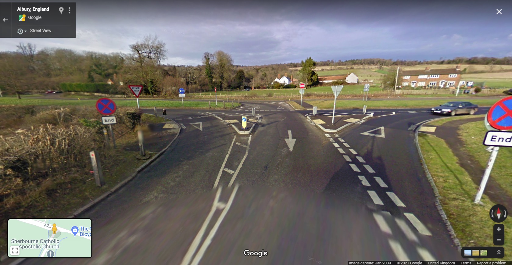
So what of the UK? Have we purposely build any voorrangsplein? In response to last week's post, lots of people made suggestions on Twitter, but nobody found one. Some examples were 2-lane dual carriageways with additional right turn lanes (and a lack of U-turns for right turning traffic) whereas voorrangsplein are 1-lane dual carriageways. Some didn't have the right turn pockets, even if the road was a 1-lane dual carriageway. The only one so far to come close was emailed to me and it's on the A25, near Dorking.

It's a very long junction (290 metres between the right turns), but the layout operates as a voorrangsplein. There is a local 40mph speed limit, but in classic UK style, the junction is full of paint and signs (view from the side road);
Drivers are required to turn left and so the movements are being broken down. The give way on the left of the image is a slip road from the main road and whilst it gets left turners out of the traffic flow, this slip road creates a new collision risk with drivers coming from the central reserve.
For those needing to turn right, they turn left and then right into this incredibly long right turn pocket which for my mind is stretching it (literally) from being a true voorrangsplein.

Here's the view on the main road in the other direction where the U-turn enters the main road. It really is dead straight and so lacks the speed-reducing feature which is some 200m before this point (because of an awkward site access);

So, close but no gold star here because there is a significant casualty collision history here which demonstrates that Sustainable Safety hasn't really been applied;

So would I use voorrangspleinen in the UK? Well yes I would, but in the right locations. For the UK, I would give walking and cycling priority because I think it's safer for the contexts, although I might be tempted to use signalised crossings with them.
From an inter-urban point of view, they could definitely help with crossroads layout issues (staggered and non-staggered), but you would need to properly step speed limits down and be very careful to use the right approach geometry to slow drivers. This layout is not appropriate for high speed situations and care is needed throughout the process.
Thanks to all who have provided comments and discussion on this little known junction type and I wonder if we'll get more identified?
With regards the geometry, whenever I've looked at ideas for putting in one of these I've basically used the DMRB link design for the minimum radii on approach, the ghost island dimensions for the lengths of the deceleration lanes and the junction design guide for the turning radii. Things that are familiar to a UK engineer but that could be slightly tweaked for this situation. This also has the benefit of making the size appropriate to the location, urban or rural, 30mph or 60mph, etc..
ReplyDeleteAndy R.