
This week, I'm going to pick on a fairly new cycle track in London as handy little worked example on the application of Local Transport Note 1/20 Cycle Infrastructure Design.
The cycle track in question is on Westminster Bridge, a location which has seen changes in recent years due to the threat of vehicle-borne terrorism and I'll come back to that shortly. If you go back a few years, the bridge simply had narrow advisory cycle lanes in each direction along with a bus lane and a general traffic lane in each direction.
After terrorist attacks in 2017 where vehicles were used as weapons, several bridges in London were quickly fitted with temporary crash barriers to protect the crowds crossing them. For Westminster Bridge, barriers were added next to the footway, although the remaining carriageway space was tweaked to provide slightly wider mandatory cycle lanes by removing a central hatched marking. I took the photograph below in May 2018.
Although the central section did give a bit more of a buffer from the bus lanes, the space at each end saw them replaced with general traffic which felt a little less safe, although by the Autumn of 2017 the eastern side of the bridge (on Westminster Bridge Road) was being remodelled to provide cycle tracks and floating bus stops which immediately felt safer. This was part of much larger works to redesign the gyratory on the eastern side of the bridge (south of the Thames technically, but there's a bend here!).
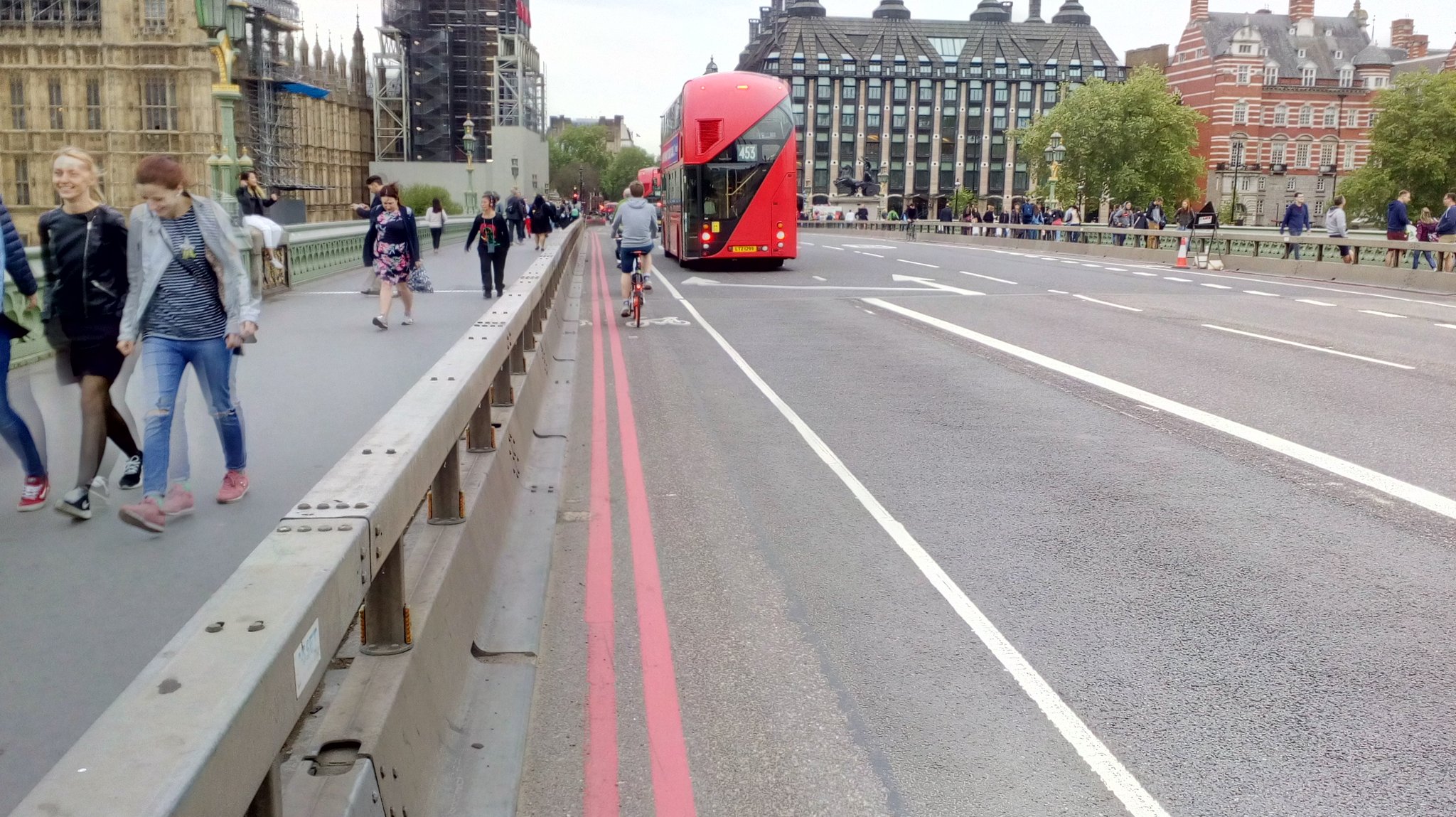
Towards the end of 2021, work started on the bridge to replace the temporary crash barriers with a permanent counter terrorism solution which was essentially a line of bollards with special foundations design to resist penetration by a vehicle for obvious reasons. This also means anyone crashing into them without such intent is going to come off badly, but counter terrorism response in the built environment has been given precedence. This type of measure is called "hostile vehicle mitigation" (HVM).

The new layout gives a pair of with-flow island-protected cycle tracks which are 1.5 metres wide which felt tight to use and so this is where I was interested in looking at them against the advice in LTN1/20.
The most obvious think is the space provided. People cycling don't do so along a fixed path. People all cycle differently and their cycles are different. Gradients, crosswinds, surface condition, personal strength, confidence and experience all play a part in how people move through space. This gives what is called a dynamic (kinetic) envelope or "wobble room". People and their machines take space which is recognised in S5.2 of LTN1/20.
People moving more slowly wobble more and gradients make people slow down which is exactly what one has on Westminster Bridge which is higher in the middle than the sides. Conversely people going downhill will be less wobbly, but if they clip a kerb or roadside object, then the fast they are going, the more likely they are to be hurt. It can also get windy on the bridges of London and this is a specific local issue which can cause people to wobble.
Table 5.1 of LTN 1/20 recognises the different types of cycle and proposes the "design cycle" which occupies a footprint of 1.2 metres wide by 2.8 metres long. This is a proxy for different machines and arrangements, including trailers. Remember, such a cycle in motion will also occupy a wider dynamic envelope than when it is stationary.
Table 5.2 of LTN 1/20 gives us cycle track and lane widths in terms of their capacity. For with-flow (one-way) facilities, 2 metres is the minimum width which will give you up to 200 cycles per hour at peak utilisation, although this will feel quite crowded. There is an absolute minimum of 1.5 metres at constraints, although there's no guidance on over what distance this would be appropriate. If we can get 2.2 metres of width, then there is space for overtaking which increases capacity to perhaps up to 800 cycles per hour.
Table 5.3 of LTN 1/20 talks about the additional width needed at cycle tracks because of kerb types or being near vertical features. Although this is presented as additional width needed, it could also be used to calculate width lost. Kerbs heights of over 60mm increase the risk of catching pedals and so an additional 200mm width is needed. Features above this, but under 600mm high need an extra 250mm and anything higher needs 500mm as we are into the risk of people catching their handlebars. This is also why things like sign posts and lighting columns need setting back from cycle tracks.
Westminster Bridge has a 1.5 metre wide cycle track. The nearside kerb is square with a vertical face which I estimated to be above 60mm. The offside kerb is around 100mm, but it has a 45° splay which does reduce the risk of pedal strike a little bit. I have sketched up a cross section of what has been built and overlain some of the information from Tables 5.1 and 5.3 (below).


There were a couple of design details which could have improved this. First, the kerbs could have been replaced with 50mm high 30° splayed kerbs which are fairly common in Dutch practice. 50mm is a touch better at avoiding kerb strikes. The photograph above shows this concept which is also known as a "forgiving" kerb because if you do get too close to it your mistake is forgiven. The 30° splay is also less likely to throw you off if you clip it with a wheel and at low speeds, they do allow people to bump up and down the kerbs a little more safely (maybe to access premises).
Westminster Bridge is a popular tourist route and so vertical separation between the footway and cycle track makes perfect sense in terms of showing clear space for each mode. On the offside, a forgiving kerb makes less sense as we don't really want people trying to get close to the bollards because if a someone cycling hit them, they will know about it. Although kerbs under 60mm don't need extra space reading Table 5.3 of LTN 1/20, I'd argue that it is only forgiving kerbs that don't need it and even a low upstand on a vertical kerb is risking catching a wheel.

The other thing which could have been done is simply to have lifted the levels of the cycle track to reduce the kerb face, although I accept that would have made dealing with the bridge joints more complicated and I understand why the cycle track is at carriageway level (above).
The cycle tracks on Westminster Bridge have been designed as a compromise. The skinny islands carrying the HVM bollards are about 700mm wide and so without them, this could have been a narrower buffer unit of maybe 300mm wide as used in other parts of London. Immediately that would have got us 1.9 metre wide cycle tracks which would have been more comfortable to use. There is also the wider highway network considerations. Although there's a bus lane and general traffic lane each way, this changes at each end where there are junctions and so traffic capacity (including pedestrians and cyclists) is a consideration.
There might have been the potential to steal a little footway space, but I am less of a fan of doing that because walking needs space and on bridges, this is important because people are funneled to crossing at that point. Perhaps a two-way cycle track would have been better. It certainly would have met Cycleway 3 on the western side easily as that's two-way, but on the western side, it would mean a different arrangement with the gyratory where I think the with-flow cycle tracks are pretty intuitive (and I prefer with-flow in urban areas in any case). I cannot blame the HVM work per se, but it is a downstream reaction to issues which need dealing with upstream. It has influenced this design of course, but hopefully you'll see the wider network influences at play.
Beyond the bridge itself, the redesign of the gyratory has really improved the feeling of safety in what is a pretty significant junction. One thing which would be fantastic to build upon would be to add cycle tracks to Westminster Bridge Road between the gyratory and Baylis Road which I looked at last week. This would really add density to the cycle network in this part of Central London - in fact, it's really showing up how sparse it is on the other side of the Thames!

One of the interesting little features of the gyratory work is the treatment of cycle traffic at the signalised junctions which give decision points. Above is a photograph of the decision point where turning left takes one onto Lambeth Palace Road and right takes one onto Westminster Bridge. There is a traffic signal pole of each movement consisting of a standard high level signal for those approaching the stop line and a low level signal for those at the stop line - I thought it a very tidy and intuitive layout.
I will leave you this week with a video looping over Westminster Bridge and back, via part of the redesigned gyratory.
Fascinating to look at and consider the compromises required to meet the current and future demands of active travel infrastructure in a city with so much transportation legacy. These bollards could be there for generations.
ReplyDelete