
Over the last several months, I have been thinking about Circulating Cycle Stage Junctions and thought that it's high time I wrote about them.
Circulating Cycle Stage Junctions is the formal name given to signalised junctions which have all cycle movements running at once in an orbital fashion around the junction (usually with-flow and clockwise). They're covered in LTN 1/20 (for England) in Section 10.6.21. There's very little guidance on them because we haven't built many, although (reading between the lines), the Department for Transport seems to be a little nervous, especially as they don't like the idea of mini-zebra crossings over the cycle track. In past days, the DfT would have undertaken research on such innovation and published specific detailed guidance.

"Green at the same time (bottom); free right turn (top)"
Deventer, The Netherlands, 2015, now rebuilt.
The other thing to note is the junction will run pedestrian movements at the same time as cycles (it's not a total requirement as variation is possible), but pairs of diagonal cycle movements are frowned upon because apparently, people cycling can't negotiate the space with each other. I am still waiting for a signals engineer to point out where this is prohibited in law however. On this, the Dutch, use the "simultaneous green" which I picked up on in my 2015 visit to Deventer in The Netherlands (above).
Perhaps the closest UK example of a simultaneous green of this I have found is outside Hatfield Station (below) where there are toucan crossings on all arms of the junction with a pair of diagonal puffin crossings. In reality you shouldn't cycle the diagonals, but people can and do. The world doesn't end. Still, this post isn't strictly about simultaneous greens, it's about Circulating Cycle Stage Junctions of which simultaneous greens would be a subset if the UK "allowed" them.

The type of protected Circulating Cycle Stage Junctions that people might have in mind will be the Dutch approach which (in urban areas) places cycle tracks between general traffic and pedestrian space. The cycle tracks being "innies" as being on inside of pedestrians (well, I have to have a title for the post!).

The photograph above is a wayfinding map at the Weesperplein underground station in Amsterdam, which is a handy diagram for the kind of layout I am talking about. Footway is grey, cycle tracks (all with-flow/ one-way) are pink and the carriageway is dark grey. In general, there is a buffer between the carriageway and the cycle tracks with the footways to the rear of the space.
From a walking and cycling point of view, the desire lines through the junction are fairly straight and the turns for cycling relatively tight (but people will be slowing down to turn anyway. The design is very scalable and can be used in some pretty tight spaces (with tightness sometimes a factor of the number of motor traffic lanes being accommodated).
.JPG)
The photograph above is of one of the protected junctions on Middenweg in Amsterdam. This quite an interesting street to look at for various design features. The main junctions follow similar principles, but there are lots of little tweaks and adaptions for local circumstances. You can see some of the common features;
- The cycle stop line is beyond the traffic stop line,
- Cyclists at the stop line are protected from right turning drivers by an island.
- There is a pedestrian refuge between the cycle track and carriageway.
In this particular location, general traffic, cycle traffic and walking get a green together, with right turning drivers held on red with their own signals, but even that varies a little bit on each arm. The Dutch tend to have some fairly complex signal arrangements compared to the UK. For example, walking and cycling may get a green to run ahead with right turning drivers getting a green a few seconds later (called a "leading green"). People walking and cycling ahead have priority over the turning traffic later into the stage, but it is a conflict that simply isn't permitted in the UK and as far as I know, it is a practice which is gradually being eliminated in the Netherlands anyway.

The photograph above is another part of this junction which again shows a protection island. The protection island helps to keep the turns tight and also works to try and provide stopping space for a turned driver about to cross the ahead cycle track. You can also just see on the top left of the photo, the ends of a central islands jutting into the edge of the junction which also physically works to slow left turning drivers. These are preferable to have, but not always applied (often because of space).
Anyway, this isn't meant to be a post about the detail of Dutch signal design and for more information, have a look at this video by Not Just Bikes. So, can we have this arrangement in the UK? The simple answer is yes and in fact, the London Borough of Waltham Forest have built several of this type of junction under UK signal rules. Before I go on, I will mention that there are UK rules, but equally, I have been told by signals engineers that certain arrangements are not permitted (as the simultaneous green I mentioned earlier), yet they've never shown me an official list of things which are thus banned. Always worth challenging in my view.

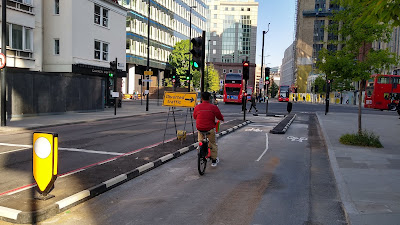
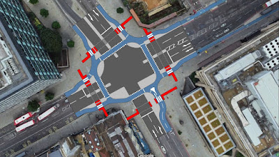
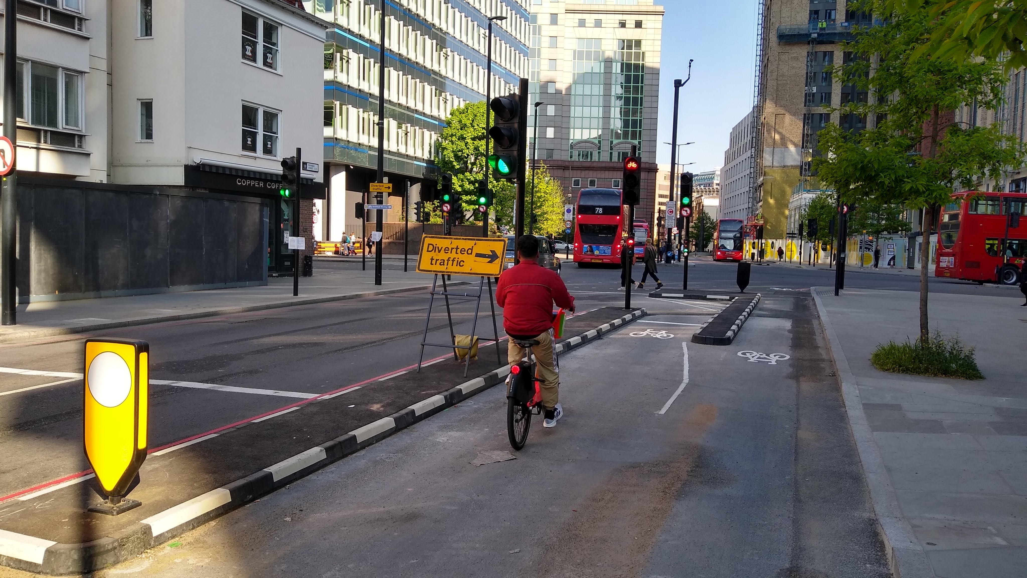
The photograph above is the junction of Lea Bridge Road with Orient Way and Argall Way. The photograph is actually of the anti-clockwise direction because with this scheme, Waltham Forest decided to make the orbital cycle track two way. I am not entirely sure why it was done this way, because in use, following the clockwise UK convention works fine for right turns which can easily be completed in the green stage. In fact, I managed to cross three of the arms to perform a U-turn on my bike in this video:
In fact having the two way operation technically means that people could cycle diagonally through the junction and "escape" on the other corner and I have seen the odd person it. Most follow the rules and cycle clockwise, although because the approach cycle tracks are with-flow. In fact, it's not really following any rules, it's just following the obvious layout (below). In terms of the traffic signal sequence, there are two traffic stages (north-south and east-west) and the third stage is the all round walking and cycling green.

This junction is a little untidy in places with awkward kerbs and lots of flush areas between cycle track and footway, but it does a very good job and in the context of lower pedestrian flows, it seems to work fine for walking and it certainly has larger pedestrian waiting areas than some Dutch junctions I have experienced (below).

A pedestrian waiting area in Amsterdam. About 300mm deep!
The sketch below gives an idealised and anglicised general arrangement of this type of junction. It's squeezed in and so the central islands are omitted in the example, but with 2 metre cycle tracks, 2 metre floating pedestrian waiting areas and internal radii of no sharper than 4 metres for cycle traffic, it gives a good idea of the space needed - a total of 32 metres on the narrowest diagonal points which is fairly tight, but things could be squeezed some more.


In the sketch above, I have "hollowed" out one of the protection islands to give a little more waiting capacity at the crossing of the junction's western arm. The crossing markings narrow on exit of the crossing which reflects the fact that people move at different speeds and will naturally merge ahead. This example could be due to a busy northbound flow blocking the westbound flow. The extra space created at the northbound stop line just allows people to wait in a row to free up space for westbound cycle traffic to pass behind. This is known as the "banana and chip cone" treatment and there is much more from Bicycle Dutch in his blog post on the concept.
.jpg)

.jpg)


That's the "innie", what about the "outie"? Well, in Greater Manchester, the design geeks had been cooking up a UK version of a Circulating Cycle Stage Junction a while. I first saw the idea presented by "Cyclops Dave" at the Cycling Embassy of Great Britain's AGM back in the summer of 2018, but it took two more years before anyone could see one in the asphalt and concrete. I am of course referring to the CYCLOPS junction which stands for CYCLe Optimised Protected Signals junction and there is a whole paper you can read about the concept.
The first example was built on the Chortlon Cycleway in Manchester at the junction of Chorlton Road with Royce Road and despite the several Dutch-style junctions Waltham Forest had already built, this design seemed to be one which captured the imagination. Maybe it was marketed better, but I think the first looked quite familiar to many people, including engineers and politicians in terms of how it was laid out.
.jpg)
As you can see in the photograph above, the CYCLOPS places the cycle track crossings outside of the pedestrian crossings and hence "outie". In effect, this means instead of the 8 smaller floating pedestrian waiting areas, the CYCLOPS has 4 larger waiting areas which double up as the protection islands for cycle traffic. The Chorlton CYCLOPS has the simple three-stage signals arrangement as with Lea Bridge Road. This first example has lots of fiddly sub-islands in the pedestrian area which form tapping features for long cane users.

The sketch above is at the same scale as my Dutch example, but you can clearly see the change in the layout. At 37 metres across the diagonal, it's a little larger, but again, it could be made a tighter. One the of main disadvantages to the design is that the adaptability is more challenging because any reduction in the protection island is a reduction in the pedestrian waiting area. However, this design could be more accommodating where there are greater pedestrian flows given the waiting area capacity. There is also the potential for diagonal pedestrian crossings, but no later conversion to simultaneous greens if they were ever allowed.
.jpg)
The other thing I like about the approach is that the turns for cycles is a little more gentle size for size with the Dutch layout. This is a bit more forgiving for users of non-standard and adapted cycles. The photograph above shows a little more of the easier turning space. It also shows an advanced stop line which was a feature of this first scheme because there were concerns that "more confident" cyclists would want to go back into traffic if a general green was available. If that's a problem, then in fact the junction should be rebalanced to walking and cycling.
The other thing which is being done within the CYCLOPS arrangements is the introduction of more complex junction layouts, although many seem to end up with staggered 2-stage crossings for pedestrians while cycle traffic gets a single stage. It might be a pragmatic way to get cycling infrastructure in (as cycles need shorter greens than pedestrians), but we should be prioritising walking and wheeling far more than we are.

One of the issues with the Dutch style approach is where we want to place mini-zebra crossings over the cycle tracks. As I mentioned above, the DfT doesn't like the idea of zebra crossings over cycle tracks being in line with signalised crossings of the carriageway and this is mentioned in 10.6.22 of LTN 1/20 citing potential confusion, especially for visually impaired users.
I think that they might be over-cautious here, but if we want to help people with visual impairments to navigate what is more complex than a basic signalised junction (where we force cycles to mix with traffic), then the offset nature of the CYCLOPS crossing of the cycle track helps, plus adding a mini-zebra crossing is less confusing than the in-line arrangement. I'm happy to go with that (sketch above).
Dozens of CYCLOPS junctions are planned in Greater Manchester, but the idea has already escaped the region and one has been built on Histon Road in Cambridge (the UK's fourth), although Google hasn't caught up yet, and I'm aware of quite a few across England in various stages of being thought about and designed. If you have time, it's worth watching the Ideas With Beers session on CYCLOPS junctions as there's even more about the clever detection for cycle traffic used on the first scheme which is being applied elsewhere.
As an exercise, I took the concepts and applied them to a junction in London which I had recently visited - the junction of Whitechapel High Street (the western end of Cycleway 2) and Mansell Street, the latter of which has just been linked for cycling to the south with Cycleway 3. Appendix B of LTN 1/20 contains the Junction Assessment Tool (JAT) which is used to asses the safety of major junction schemes for cycling. To go through the process would take a post in its own right and if I am honest, I am still practicing using the tool. However, based on my knowledge, I applied it to the junction and it scored 50%.
The Mansell Street approach to the junction with a cycle gate.
70% is considered to be what is needed to be operating in the Dutch-level of excellence and although 50% is a "fail" in this regard, it is significantly better that it was and indeed, it's really good considering just how low cost the recent interventions were. The JAT can also be used as a design tool to see what could be tweaked to improve the score, but again, that's a different post.
My two redesigns have removed the staggered pedestrian crossings on the northern and western arms, but otherwise the number of lanes are the same, as are the motor traffic movements. Both designs score 100% on JAT as every cycle movement is fully protected. First the Dutch (innie) design.

The key thing to mention is the southern arm (Mansell Street) isn't completely Dutch in the context I have been explaining, because it has a two-way cycle track on the eastern side; but a Circulating Cycle Stage Junction can neatly integrate this different arrangement easily, it's just there's no "free" left turn to the west (heading into The City).
The junction all fits in quite well, give or take, but the immediate issue is the width of the floating pedestrian islands. I have designed them at a minimum depth of 2 metres, but it's still tight and pedestrian flows can be high here. They could be made a little larger, but they still represent a tight spot in places. I have also added in-line mini-zebra crossings over the cycle tracks to annoy the DfT.

Then we have the CYCLOPS version which gives far larger pedestrian waiting areas. Cycle traffic is diverted off the desire a bit, but that could be improved - the gentler turns and "outie" nature is a directness penalty. I could probably push the Mansell Street cycle crossing a bit further north and for fun, I have added a double mini-zebra to the northeast corner for a crossability improvement.
This design probably fits better with the local context which can have some busy pedestrian flows and plenty of bus movements. It also marks the point at which the east - west corridor turns from a "road" into a "street" as you enter The City of London to the west of the junction. A city centre street should ideally be low enough in terms of motor traffic to integrate cycling and The City is really pushing this idea. Seems like a logical place to make the transition to me.
We have two ways of achieving the same thing, both having advantages and disadvantages. The key for me is using the space, context and junction layout to think around the best solution. The Dutch approach works perhaps because there are so many people cycling in The Netherlands, so walking space is less of a issue. At the Mansell Street junction, walking is key and I think the CYCLOPS is the better option. You pay your money and you take you choice and maybe we'll be swapping successful CYCLOPS junctions for Dutch layouts in 30 years!
Personally, I think an outie is the best option in general, since it would usually give larger waiting areas for pedestrians (perfect for wheelchairs, mobility scooters and/or large amount of pedestrians). It also allows a more circular cycleway around the junction, which could lower entry speeds for cyclists (opposed to practically a straight line), improving safety all round.
ReplyDeleteHowever it is very situationally dependant.
In the coming year the roundabout on the southern end of the A23 in Brighton will be turned into a "CYCLOPS" junction, however it will not operate as a "Circulating Cycle Stage Junction", does that mean it can still be called a "CYCLOPS"???
https://democracy.brighton-hove.gov.uk/documents/s173290/Valley%20Gardens%20Phase%203%20revised%20scheme%20with%20detailed%20design%20principles%20APX.%20n%201.pdf <- This is the junction design and will operate as three phases, with the cycle track and pedestrian crossings working in vacant space around the motor vehicle phases. (not hard to work out the phases).
The design also has a few other issues like a few of the crossings being over 15m & cycleway links being a a little odd with random giveway lines despite being signal controlled.
Thank you for another great post. Having recently discovered the Mansell St tracks (thanks to you!) I was interested in how this junction (which is pretty grim right now) could be redesigned: the cyclops option looks decent and hopefully accommodate the high footfall as well as growing cycle numbers. Let’s hope TfL implement it (and make the Mansell St tracks permanent)
ReplyDeleteHello Jervi.
ReplyDeleteLooks like B&H are proposing a Dutch innie, not a British outie. Not sure why they aren't operating it as a single stage, would seem to work well in this case.
Ranty -
ReplyDeleteMy issue with the CYCLOPS at Mansell Street is for those turning right from M St towards Whitechapel. Do you think there's room to continue the bidirectional track across the crossing on that right side?
How many bikes store at the forward stop line before they are blocking ahead cycling movements trying to pass behind them? Doesnt take many to block it up. Not as big an issue in the Netherlands as they go through the cycle times pretty quick.
ReplyDeleteThis is an extremely illuminating blogpost. I had assumed, due to reverse chauvinism, that the UK way of handling these junctions would be a poor imitation of the Dutch design that made compromises to avoid upsetting drivers, so it's great to have it laid out where their advantages lie.
ReplyDeleteI think I've spotted a few more pluses of the 'innie' design: pedestrians making two road crossings only have to cross cycle tracks twice, versus four times with the Dutch design; and cyclists making a 'free' left turn only interact with pedestrians once, instead of twice. In addition, all cyclist movements in the 'innie' have a cycle give-way line before the first pedestrian crossing, so cycle speeds may well be lower at the point of interaction with pedestrians.
On the negative side though, and I think this might be significant: right-turning cyclists have to cross a pedestrian crossing /during/ their green light road crossing phase. Aware that they have limited time to complete the manoeuvre, and proceeding on a green light, cyclists will be less likely to stop at the pedestrian crossing midway through. It'd be interesting to see whether this is an issue in practice.
Fair points there I think - it's also about selling a layout that "feels" it is from the UK a bit too. The walking/ cycling interactions are difficult because they have to happen somehow. I suspect that there will be limits of cycle flows and ped capacity on the islands too.
Delete