There seems to be lots of talk out there around enforcing guidance and so I thought it might be useful to explain why this is wrong, but possibly right at the same time.
I'm of course thinking about changes to our roads and streets (as always) and so I think it is worth setting out some basic concepts before diving in. First - what is a law?
From a highways management point of view, a law gives duties to people/ organisations and the necessary powers to fulfill those duties. A failure to comply will give rise to potential criminal and/ or civil liability. A law may also set a minimum level of behaviour which equally gives rise to potential criminal and/ or civil liability for those breaking such.
We then have standards which will prescribe how things should be done in order to ensure consistency. It may be that a standard could be used to ensure compliance with the law. We also have guidance which perhaps explains how we might comply with the law or comply with a standard. It might also set out what best practice might be.
Finally, we have policy. This is something set by a body in charge on what they expect to see. This could be a very high level around what outcomes are important or it could be specific in how a standard or piece of guidance should be applied. One could argue that a policy might also be a standard or a piece of guidance? Yes, it is all a bit confusing.
In the UK we have two types of legislation to be concerned with - primary and secondary. Primary legislation is concerned with Acts of Parliament and they exist to set a framework within which to work within the area being legislated for. We then have secondary legislation which take the form of Statutory Instruments (setting out how things are to done in more detail).
For example, the Road Traffic Regulation Act 1984 (RTRA1984) is, unsurprisingly, an Act which about how traffic (in its widest sense) should be regulated. Despite being a volume of hundreds of pages (for print enthusiasts), it doesn't provide the full detail needed to regulate traffic, but it points to the appropriate secondary legislation.
Take traffic signs. Part V of the Act is where local authorities are granted their powers to erect traffic signs, but there's no information on what they should look like. In order to provide this level of detail, the Act (under S64) grants powers to the Scottish Ministers, Welsh Ministers and the Secretary of State (Northern Ireland has a separate system) to issue secondary legislation. In this case, all three administrations have one Statutory Instrument - the Traffic Signs regulations & General Directions 2016 (TSRGD 2016).
An extract from one of the schedules in the TSRGD2016
which shows the layout of traffic signal units.
The TSRGD2016 has extensive text explaining in detail how and when traffic signs should be used, along with a whole series of schedules with drawings showing the form of traffic signs, how they may be combined and other information required for consistent design and deployment.
What if people don't follow the law? This gives rise to the potential for criminal or civil sanctions, depending on the law involved - and this is where a legal brain needs to comment! For highway and road traffic law, the criminal side tends to be around the sanctions for breaking rules just as exceeding the speed limit, whereas the civil side tends to be around more minor issues such as people putting up unlawful signs which would be dealt with by the highway authority.
Back to TSRGD2016. This is still a complicated document and so we need some guidance. This comes in the form of the Traffic Signs Manual (TSM) which is arranged over a number of chapters and sets out in detail where and how traffic signs (including road markings) may or should be used (some of the advice is around the mandatory and some is advice on the possibilities). Of course, given that the TSM gives information on mandatory requirements, then I'd argue that it is both a standard and guidance.
Chapter 6 of the Traffic Signs Manual
The Design Manual for Roads & Bridges (DMRB) is often cited by highway authorities and campaigners. If I were to be playful, I would say it gets cited when it suits an argument. In fact, the DMRB is essentially a set of standards stretching over a number of documents which are for the planning, design, construction and maintenance of motorways and trunk roads which are operated by Highways England, Transport Scotland, the Welsh Government and the Department for Infrastructure In Northern Ireland (national organisations).
There's also lots of notes of guidance surrounding how things should be done, so we have the hybrid of standards and guidance again, but the stuff that has to be done is very much a standard. For example, CD109 - Highway Link Design, sets out how roads are set out with width, length of overtaking sections, horizontal and vertical alignment and so on. The DMRB is all about providing drivers with the consistent and predictable experience required when moving at high speeds and it's why the four national organisations often struggle in historic locations within which the standards don't fit.
This is also why we end up building bypasses of bypasses because the older roads are seen as "substandard" or in some cases, the road is "detrunked" and the local highway authority ends up with a mess to deal with. It's also why trunk road and motorway schemes go through an area and leave weirdly wide bits of road over bridges road tie-ins because they have essentially rebuilt a section of local road to the DMRB standards.
When local highway authorities use the DMRB, they may be building high speed roads which, to the average punter look, and feel the same as a road operated by one of the four national organisations. However, their decision to use the DMRB is a matter of policy. In this case the DMRB may be looked on as guidance in terms of any official status and this is important because in many cases, there is a great deal of picking and choosing on which bits of the DMRB get applied.
From a campaigner's point of view, it is easy to get sucked into the detail of the DMRB with the use of it to "prove" a single point. This might be appropriate if the local highway authority is using the DMRB for a scheme, but I would suggest working a bit smarter and maybe question why the DMRB is being used in the first place and why (inevitably) they are cherry picking what they use.
For the four national organisations, it is a comprehensive document to be applied in full (for the situation) and bits cannot be ignored if they don't suit and so if a local highway authority is cherry-picking they need to be clear on why they are doing so.
I recently reviewed a new road scheme which was apparently designed in accordance with the DMRB. One of the issues with the scheme was a shared-use path was proposed against the carriageway without a verge buffer on a high speed road. It was accepted by the highway authority that a verge was required, but that the design was not going to be changed. In other words, they had decided to use the DMRB as guidance where their design did not meet the standard. More than that, it wasn't clear why they had gone for the shared-use path in the first place which is a very common starting point, rather than the conclusion after proper analysis.
One thing which has come up recently is the scope and use of the new cycling design guidance; Local Transport Note 1/20 - Cycle Infrastructure Design. Some people have been asking how it will be enforced. Well, it is guidance, not the law. Of course, local authorities may adopt its use as policy which might sort of make it more of a standard, but unless the policy can set out how the document is used, that is going to be tough because the guidance gives options and allows nuance. If there are specifics a local authority requires, it needs to define them.
LTN1/20 has essentially been linked to government investment in schemes (in England) and so one could argue that this is a policy position which again pushes this towards a standard, but unless the touted Active Travel England has powers and resources to call-in and demand changes to designs, then it's hard to see how there will be enforcement (from a policy point of view). It may be that schemes have to be submitted to a design review for example, but the government will argue that local authorities are the best placed to make decisions.
LTN1/20 should be the starting point for local highway authorities. We are already seeing it being used by planning authorities to reject planning applications and in time, we'll see it in planning appeals and potentially used as evidence in criminal or civil actions where a designer has failed to take it properly into account. This stems from it having official government backing. So there's guidance and there's guidance!
It's a complex subject to be sure, but if we are at the point where we are arguing about what is on a drawing and how it might comply with the law, standards or guidance, then maybe something as gone fundamentally wrong upstream.
As I reach the end of my 10th year of cycling for transport, I thought it would be nice to tell you a bit about my cycles. They often appear in this blog and in my tweets; and I'm often asked about them.
I returned to cycling at the start of January 2011 as a means to get to work. I had moved offices from the edge of the countryside to the town centre where I was sitting in traffic twice a day for a 3.5 mile journey thus pushing me to make a change. I had an old Apollo bike at the time which did the job, although unfortunately it was stolen from the supposedly secure compound within a few months.
I then got myself a Carrera Subway (below) which was a really nice bike and I rode it for a few years to and for work. It's still going as a beater for my son, although it's a bit knackered now and sadly not economical to overhaul.
Looking back, the Carrera had 21 gears which was *way* too many and the thumb-push gear changers eventually became a bit painful to use and so I was on the look out for a replacement, although I had managed (I think) a good four years out the bike which included a go at the London to Brighton cycling event.
Next was my big Specialized which I got in the Spring of 2014. I've no idea what model it is, but it had one set of 8 gears on a twist grip - my thumbs were saved!
It had an extra low first gear which I put to good use when I used it on the London - Surrey 100 Classic in August 2014, although it got cut a little short by the organisers as a storm hammered the country on the day of the ride. An odd choice I guess, but I struggle with the riding position on racers. I came a bit of a cropper on it in December 2018 when a right turn on some ice had me and the bike part ways. I've still got the bike, but it needs an overhaul and maybe I should get shot of it.
Now, in August 2017 on a trip to the Netherlands, I hired a Batavus Personal bike from our campsite in Amsterdam. The bike was a tank, which is probably why it was a popular choice for hiring. In fact, you see them all over the city being used by tourists.
Back in the UK, I had always fancied one and in the Autumn of 2018 I got my hands on one. It's a 3-speed with a coaster (back-pedal) brake, a rim brake on the front and a little dynamo bottle on the front for the headlight (which can be engaged and disengaged). As is the style of the model, the frame number is cut out of the little low cross piece on the frame and this one is A655 (below).
It was a fairly cheap Ebay find and despite having a smallish frame, it was fun to ride, much easier to get on the train than the Specialized and so without really thinking about it I started using it more and more and the Specialized less and less.
As fun as A655 was, I really wanted something a little larger and so I kept an occasional eye out on Ebay. In the Spring of 2019 I spied another Batavus Personal which had a larger frame. I put my bid in and ended up paying only a fiver more than the other one. This one is frame number M3276 and is third hand. The chap I bought it from had used it a bit, but found the three gears to be not enough for his local hills. He got it from a defunct pool bike scheme where it had been barely used and he had kept it in his garage.
M3276 is a *really* nice bike. It has three speed hub gears with a pair of roller brakes, an LED dynamo front light (which I just leave day running), fully covered chain, a heavy duty rack with a battery-powered rear light, front and rear integrated mud guards, a jelly seat and a frame lock. I added a chain which plugs into the frame lock, a trailer towing ball and a set of rechargeable LED lights. I also invested in a set of Clarijs pannier bags, including a shopping bag which fits neatly inside;
Being able to get out and ride this past few months has been a lifesaver mentally (as I have been working from home since March) and my trips have been functional with regular runs to the local parcel post boxes for Mrs RH's business (below) and of course others have seen me cycling all over East London looking at infrastructure to write about.
I had M3276 serviced by the lovely people at Havebike at the end of the Summer because it had taken me so many miles each week. I splashed out on a set of Marathon Plus tyres which are puncture resistant, but of course I then got a puncture a couple of months later. I am an old hand now at repairing punctures without taking wheels off because frankly, Dutch bikes are a pain to get the wheels off with all of the hub gears and whatnot.
You can by gaadi inner tubes which makes replacement without removing the tube possible and that's what I have on the rear, but hopefully punctures should be rare. As a day to day cycle, my Batavus Personal Bike is easily the best I have owned in terms of it's specification and comfort in use with a fully upright position and a step through frame.
I think the only thing I would change is the rear brake because I do like coaster brakes and the roller brakes are not as sharp as other systems (but they are not affected by the weather and pretty much maintenance-free). I suspect the pair of roller brakes come from the bike being used as a pool cycle because coaster brakes need a bit of practice (my Dutch hire didn;t have a coaster brake). There's also a version with a front rack which would make it even more versatile.
I wish I knew today back at the start of 2011 as I would probably have gone for the Batavus from the start, although I don't think I could have done the two long distance rides on it, although I topped 40 miles on it for my safari ride to Enfield a few weeks back.
Now that's not the whole story. I have two other cycles which I regularly use. First is my Tern Link D8 which is a folding bike. I bought it in the sales at the end of December 2012 in order to have something a bit easier to throw on the train or in the boot of the car for occasional use. It has been used a fair bit in London as well as travelling around the country to look at infrastructure.
I put M+ tyres on it's 20" wheels some years back and other than adding a set of LED lights and a bag for it's integrated rack, I've not changed a thing and it has only had one service - of course being a folder it's convenient to keep indoors which helps keep it in good condition. One slight issue is that when folded it is luggable rather than portable so you'll want to unfold it to move any distance rather than try and carry it.
It's a nifty all-rounder really and could easily suit someone as a day to day bike. Tern do a slightly different model with hub gears which is very nice. I think the brand has developed really quality bikes in recent years although the price tags are a higher to suit - I'm glad I picked up the bargain when I did.
Finally, my other cycle is perhaps the most famous of the three on Twitter because it has it's own feed, it is of course @LDNSharkTrike. This is my Christiania Tricycle which we got third hand in early 2016. I must admit, it wasn't a vital purchase, but after trying one in 2015, the opportunity to own one was too hard to resist.
As it has turned out, whilst it's not ridden every day, it has replaced shorter car-based trips to shift stuff such as bags of concrete and timber from the local big box DIY store, supermarket shopping trips into town and joyrides out with the children, although the youngest will probably outgrow the ability for my legs to pedal with her within the next 18-months or so!
It's great fun and shows how practical a cycle can be and in fact, even with some basic infrastructure it opens up all sorts of possibilities. My local trips with our youngest child is all on shared-use paths which makes cycling easy. It's no wonder that they are so popular in their home city of Copenhagen.
Finally, I have one cycle which I only occasionally use because it's so damned terrifying to ride. It's an old Giant Peloton Superlight which I inherited from a friend who could no longer ride it because of their hip. As I said earlier, I do struggle with racing bikes, but it's just a nice thing to look at, it may need going on the wall as a piece of art, only to be ridden a few summer Sundays!
So there you go, that's my cycling history. What do you ride? What's your dream cycle - do you already have it?
In last week's second post about my nose around Enfield, I was having a look at London's Cycleway 20 which runs along the A105 Corridor. At the junction of the A105 Ridge Avenue / Village Road and Church Street / Bush Mill Road, there is a connection with another route - C21 and it is there I pick up this week's post.
You'll recall as I was heading south into the junction I saw a sign which explained the various routes, well the next part of my journey was to turn left into Church Street to head southeast onto C21 as I wanted to get to the eastern side of the A10 to look at another north-south cycle route;
The area around the junction is shared to serve the toucan crossings, but there is a short section of two-way cycle track on Church Street which runs to Blakesware Gardens. The route crosses Bury Street West in a way which almost had me fall off my cycle. Bury Street West must be a busy junction for motor traffic because drivers leaving it have separate left and right turn lanes - the road is part of a short, direct route to the A10. There is no priority for people walking and cycling, although the confusing use of the elephant feet road marking and green stripes for walking doesn't help (below, looking northwest).
The thing that nearly had me off my cycle was the stagger between two of the cycle crossings. As you come south, you cross traffic entering the side road and then the traffic turning right out of it. The crossing for traffic turning left from the side road is staggered and when you are trying to concentrate on drivers, this stagger is easy to miss and I ended up swerving onto the pedestrian side.
When you go back in time on Google Streetview to look at the previous layout, there wasn't a decent crossing for pedestrians (nothing for cycles) but at least it was all in line. The same arrangement of traffic movements was there and so while the new layout is tighter and in theory easier to cross, it is still designed for motor traffic.
The cycle track ends at Blakesware Gardens where cycle traffic is returned to the carriageway for a back street and greenway style route which follows Salmons Brook route (east - west) via a toucan crossing on the A10 and then a turn south onto Latymer Road. I missed the fact that this route crossed the B154 Church Street and so I headed east on Church Street towards Edmonton.
About 500m east of Latymer Road, Church Street connects with the Edmonton Green roundabout and cycle traffic is immediately welcomed into a kerb-protected cycle track on the A1010 The Green. As I headed north, I stopped at a parallel signalised crossing of Balham Road (above). Unfortunately there is no legal way to turn left into the side street and leaving Balham Road on a cycle is awkward. For my mind, this junction would be much better filtered because it wouldn't need to be signalised and so would allow all cycling movements as well as creating a decent low traffic neighbourhood to the northwest.
The whole of the Edmonton Green roundabout has been redesigned to accommodate cycle traffic (and to better serve walking) on what I immediately learned was Cycleway 1, a fact that I hadn't picked up on until I saw the first marking on the cycle track!
A little further on, the A1010 becomes Hertford Road and the cycle track becomes two-way on the western side due to the way the Edmonton Green roundabout has been designed - a with-flow orbital cycle track which I'll come back to later.
The standard Enfield treatment was present on this nice section of cycle track alongside a residential estate, although being away from the main road meant that quite a few people were walking there because it's nicer than walking by traffic!
The two-way section rejoins Hertford Road northbound and southbound with-flow cycle traffic joins the two-way section with a signalised cycle crossing which oddly doesn't have a parallel pedestrian crossing. When I headed back south, this crossing took a really long time to provide a green (below).
Continuing north, the standard Enfield treatments can be seen with floating car parking, light protection and junction treatments as can be seen at the junction with Bridlington Road (below), as well as the "boarder" style bus stops as we saw on C20.
The use of planted rain garden build outs certainly helps change local geometry to slow drivers at the junction, but there is still the ambiguous use of elephant feet with bellmouth kerbs and double yellow lines (below);
The junction with Galliard Road and the B137 Nightingale Road is quite interesting. It's a staggered signalised cross roads and there are signalised pedestrian crossings on each arm.
From a cycling point of view, the crossroads has been somewhat unbundled into two T-junctions for cycle traffic. To turn right into Nightingale Road, you have to move out of the cycle lane into an advanced stop line which is awkward. If you're coming south and want to turn right into Galliard Road you are going to have to use the pedestrian crossing because the layout doesn't give the opportunity.
The cycle stop lines in each direction are beyond the side roads on the right and the crossing of the side roads on the left is via parallel signalised crossings with pedestrians and again, there's no legal way to turn off the main road (below, with unhelpfully managed works going on).
At the northern end of this section of C1, I arrived at Ponders End and I was caught off guard by what I came across. The A1010 has now become High Street and at the junction with Lincoln Road (below), Derby Road and South Street, the whole area has been repaved with a pair of "implied" mini-roundabouts and "courtesy" crossings. The footways and carriageways are paved in similar materials and there is a very low kerb upstand between the two.
This layout has nothing to do with the C1 scheme, it predates it and as best as I can work out, it was completed in the Autumn of 2017. The scheme is part of a much larger regeneration project for Ponders End and the junction scheme replaces an old signalised arrangement which had no pedestrian crossings. You can still see this in Google Streetview. According to a council newsletter from the Winter of 2017;
The new layout will create wider, less cluttered pavements and should provide easier crossing opportunities. It will also help smooth traffic flow and provide better for cyclists.
Better *what* for cyclists I can only guess at because the the only vague nod to cycling is a series of cycle logos on the footway next to the "courtesy" crossings which suggests that people can cycle on the footway - these implied cycling crossing points don't always coincide with flush kerbs and it's really confusing to use. The pedestrian crossing points kind of look like zebra crossings, but they aren't
In fact, it's so ambiguous, drivers have to have it explained to them with a sign;
The street undoubtedly looks better than before I guess and motor traffic will certainly flow far better than the old signalised arrangement, but frankly, it's poor for walking and atrocious for cycling. Had I known what to expect I would have stuck to the carriageway, but many people won't and so being thrown here after the comfort of CS1 is all the more stark.
The other problem is the junction still has buses and HGVs running through it and so the council will be forever repairing the expensive carriageway paving. If the carriageway had been left with an asphalt finish, and if proper zebra crossings had been provided, I could almost excuse the lack of help for people cycling - at least it would be clear. You'll see in the video for this week how I had to be quite assertive in following the cycle route around the junction.
There is a cycling project underway beyond Ponders End on the A1010 where is becomes Hertford Road again and I'll watch with interest to see how that develops.
After riding around the implied cycle route through Ponders End High Street, I heading back south again. Just south of Tudor Road, there is a wonderful little piece of public realm work outside a parade of shops (below).
The cycle track runs behind a row of angled car parking spaces (with a good buffer). The existing trees were worked into the scheme and additional planting and new seating added. The car parking bays are angled so that southbound drivers have to reverse into them which is a good arrangement, although some people decide to swing in from the other side of the road.
At the junction with Bounces Road, there is a "cycle gate" (below). This is arrangement is essentially a signalised advanced stop line where cycle traffic gets a separate green signal to get to the second stop line while drivers are held on red. Then, the second stop line and the first driver stop line gets a green at the same time (or cycle traffic also gets an early start) so that people cycling are through the junction and either round the corner or back on protection on the far side before drivers catch up.
I'm not party to the design decisions here, but it's quite a narrow road layout, with a tight turn into Bounces Road, so it's a solution for the location and as space has been reallocated to cycling, it's hard to criticise the layout even if as a someone cycling you will always stop. Until and unless we reduce traffic on these sort of roads, then we will have to use signalised solutions like this.
I was then back at the Edmonton Green roundabout, and I'll leave you to watch the video linked at the end of this post, but I think it works well and is an interesting example of a signalised roundabout with "hold the left" signal staging; in other words drivers leaving the roundabout will be held when cycle traffic is crossing the vehicle exits. I don't know how the timings are set up here, but on my southbound cycle, I ended up with a sequence of green signals in my favour which was great.
You could in theory have a Dutch style roundabout with an orbital cycle track and with priority crossings over the arms with parallel zebra crossings, but with multiple lanes and potentially heavy traffic flows, it wouldn't be appropriate here. This is very much a UK solution to a UK problem and I think it works well. The roundabout also directly serves the Edmonton Green shopping centre and Edmonton Green station - there's even a dropped kerb to allow people to get from the cycle track to the station and the cycle parking which was really good.
A little further south the A1010 becomes Fore Street and there is another parallel signalised crossing passing a side road. In this case, Smythe Close which is the car parking and servicing access to the Edmonton Green shopping centre.
As I neared the end of my southbound journey on C1, I was treated to much longer sections of fully protected cycle track which ended at a large floating bus stop;
This time, there are mini-zebra crossings and a larger passenger area which seems to be because the stop is very busy. Because the cycle track is at footway level, there were a few people standing in the cycle track which may have not been the case had it been stepped. A the end of the floating bus stop there is a parallel zebra crossing which takes C1 across the road and into Park Road and on into a residential area, although I think C1 ends on Fore Street for now. If you stay heading southbound, you join a bus lane, but even that gives up as you approach the A406 North Circular Road. 600m later and you reach the London Borough of Haringey.
C1 does appear again around Seven Sisters with a footway level 2-way cycle track along the A10, but generally it's mainly a back street route all the way into the City of London along with awkward crossings of main roads, sporadic wayfinding and with the route going anywhere but the direct choice which would be the A10. But that's a discussion for another post. Still I did end up passing my office in The City for the first time since I left it in March.
I prefer Enfield's C1 route to it's C20 route, but this is probably a factor of it maybe being a little more useful because of easy access to Edmonton Green and that it's slicker having learned from C20. Ponders End is, frankly, a mess and this is now locked in for years, but that's not a criticism of C1.
Looking back over my visit and the last two posts, I think it is fair to say that Enfield has tried to deliver C20 and C1 without paying attention to how the network operates on the streets either side and that has affected some of the design choices. From my understanding (and please correct me if I am wrong), this is where the borough's politics were at the time. I really hope that the borough holds its nerve with the low traffic neighbourhoods because if the network is considered then ultimately, this means the Cycleway routes can be improved because conflicts created by drivers cutting through residential areas are removed.
It has been interesting to contrast Enfield with Waltham Forest and in fact I think both boroughs could learn from each other. Enfield could pick up some tips about managing traffic with low traffic neighbourhoods and maybe the ability to be a little bolder at the signalised junctions to make them fully protected. Waltham Forest could learn about the second generation of light/ medium protection for rolling out even more routes on links and I think the pair of them could get into a bit of a race with some of the great public realm improvements.
I'll leave you this week with a video of C1 in Enfield.
I left you last week as I was heading north on Brownlow Road in Enfield, having just had a nose around the Bowes Primary Area Quieter Neighbourhood scheme. This week, my journey around Enfield continues.
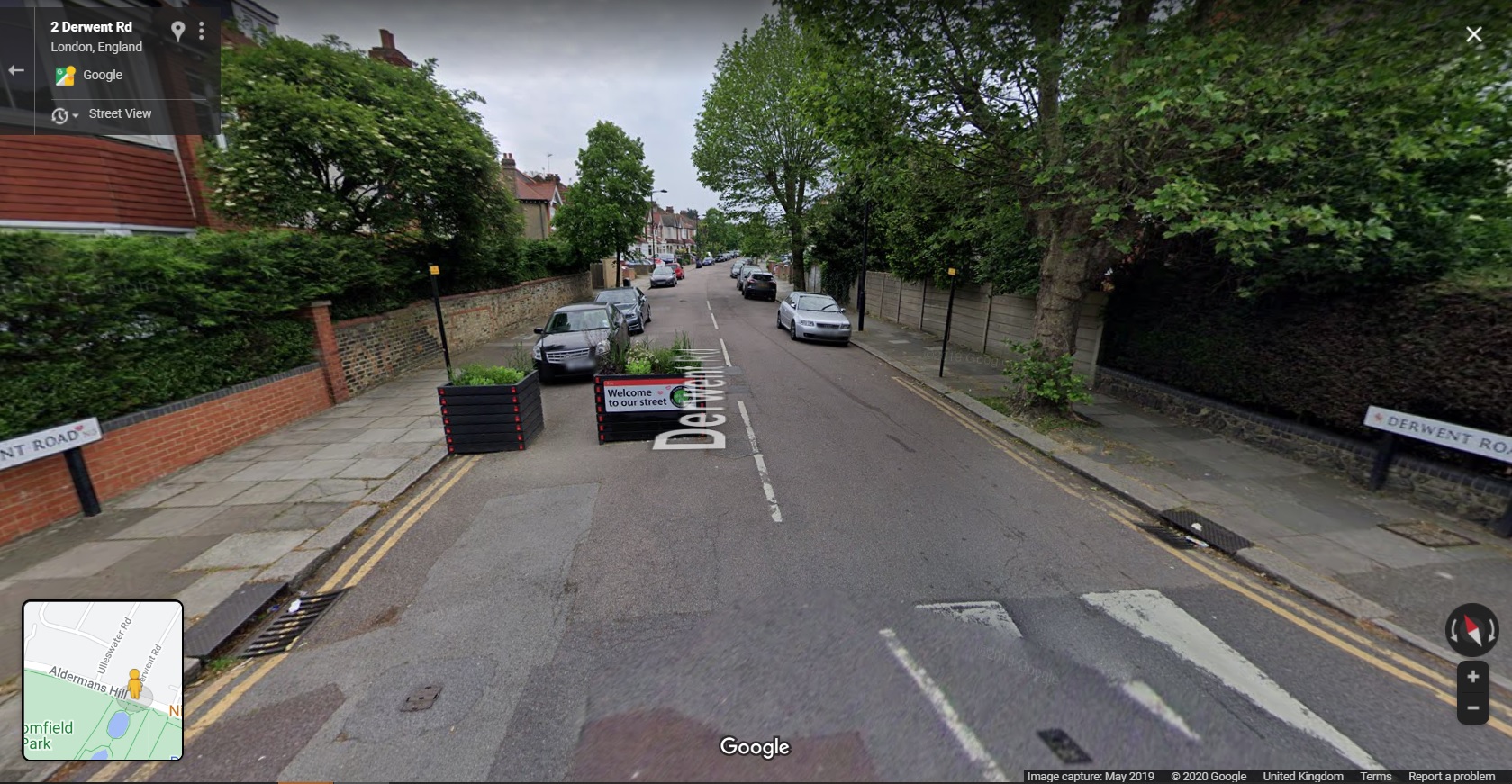
I crossed the A406 North Circular onto Powys Lane and then into Broomfield Park. At the north side of the park, I needed to cross Alderman's Hill which was awkward given the lack of dropped kerbs. Still, I crossed and entered Derwent Road which is part of the Fox Lane Quieter Neighbourhood Scheme.
This scheme is interesting because it has been a work in progress for some time - back to 2017 when you read through the information on the council's website. The initial scheme for the area relied mainly on traffic calming to deal with speeding and rat-running. From what I can work out (and correct me if I am wrong) the scheme started in late 2018 and further work took place in early 2019 - the proposals are shown on the plan below taken from the council's website;
One of the key features was to use planters on the junction entrances to and within the area to discourage drivers from entering because they would have to give way to drivers leaving the area - that idea can be seen in Google Streetview;
There were other proposals such as speed humps on Fox Lane (which runs east-west through the area). I didn't know anything about the history when I visited and so it is only now that I am seeing what happened.
Some of the planters were deployed in late 2018 and feedback ranged from residents saying they were working to residents saying that drivers were going faster past them. By the summer of 2019, additional planters had been deployed to the same arrangement. The results from monitoring showed that there had no effect on the volumes of through-traffic and so the scheme was to be removed and further ideas developed).
In the Autumn of 2019, the council announced that it had been working on other proposals which would shortly go forward as an experimental scheme to give people a chance to give feedback on a live scheme. There was a period of consultation prior to the experimental scheme which was extended to the end of 2019. Changes were made to the proposals and eventually the scheme went live in September 2020 and is now in the consultation period;
The plan from the council's website above is a little hard to see, but essentially it shows a series of modal filters (planters and bollards) mainly on the junctions to the south of Fox Lane with a couple of camera-enforced filters for emergency access use. The area is also subject to a 20mph speed limit and the red line you can see is a bus route which is maintained.
A planter/ bollard combination, Derwent Road.
It's worth having a look at the link above because there is all sorts of interesting traffic modeling analysis supporting the experiment. For example the "before" traffic flows for Fox Lane for 7am to 7pm were 9,000 - 10,000 vehicles per day with the predicted "after" being 10% of that. The modelling does of course predict higher flows on the boundary roads (this will settle down with time), but it's interesting to see that modelling has taken place in this case.
As ever, this may well be the controversial part of the scheme - hopefully there will be further traffic information gathered to see what actually happened and then maybe some longer term monitoring as Enfield suggests that there is a much longer term programme for the borough.
One of the camera-enforced filters towards the
eastern end of Fox Lane, near the A105 Green Lanes.
There has been a great deal of design and engagement work to get this far. It would be very easy for me to point out the fact that the planters at the junctions idea without filtering was doomed to fail (I'm confident in stating that), however, people need to find their own way. The value of having this ongoing live project is that the data generated very clearly showed the public and politicians that a light-touch approach doesn't work and so provides immediate feedback to the community.
This is also interesting because as one of the three Mini-Holland boroughs, Enfield had tried to get change by concentrating on building cycle routes on a couple of corridors through the borough without tackling the side streets, whereas international experience shows we need to crack on and tackle everything. The other interesting thing is because Enfield did try and tackle some main roads first, it rather confronts the assertion from those against low traffic neighbourhoods that you have to deal with the main roads first because now the borough is seriously looking at the side streets!
My journey continued into Fox Lane itself where I headed east towards the A105 Green Lanes (Cycleway C20), through the camera-enforced filter in the photograph above and then with a left turn into the A105 Green Lanes itself. This scheme has created protected cycleways from near the Haringey border in the south (with a quieter link to a crossing of the A406 North Circular Road) and just short of Enfield town centre in the north along the A105 corridor - around 5.2km. All on the western side of the A10.
I was aware of the general model that Enfield had adopted which was light protection along the links with full protection at points of conflict such as junctions, bus stops and within some of the local centres.
As I entered Green Lanes, I saw that the original light protection of wands and orcas (full-sized and mini) had been changed to bolt-down rubber kerbs with wands (photograph above). This follows a review of the scheme and the availability of more options for light protection becoming available on the market. Certainly, the new arrangement using Cycleway Defenders (by Rosehill) is much more conspicuous than the previous materials;
These 2 metre long units weigh in at 60kg each and are made of recycled tyre rubber, completely solid and bolted to the road surface. Personally, I want full-on kerbs and buffer protected cycle tracks everywhere cycle tracks are needed, but pragmatically, this is something that will take generations to get. It's also a challenge in a situation like Green Lanes where there are so many private driveways, you would have to essentially reconstruct everything. This unit comes in three styles (end, double end or intermediate) and so you can have continuous runs if that's your need.
The original light protection has also been changed for bolt-down rubber units by the car parking spaces along the route - this time the "Lane Delineator" product, also by Rosehill, has been used (photograph above). These units are 1.5m long by 0.5m wide and weigh in at between 95kg and 105kg depending on the type of unit selected (three options again). Being 0.5m wide, this product gives the desirable minimum buffer from traffic set out in LTN1/20 - personally I would always want to see more of a buffer, but this is pretty good. There of course may be issues here with some drivers or passengers being unable to cross the kerbline - maybe there needs to be a review to provide some accessible spaces.
Again, the units are bolted down and can be quickly deployed to give a permanent run of kerb protection to a cycle track. Here is the product being installed in Enfield;
I really like this unit because it's heavy and looks the part from a driver's point of view (more so than the narrow unit). Where an existing road is wide enough for an in-carriageway retrofit scheme, this is a much easier unit to install than concrete products which may require a recess to be formed in the surfacing and reinstatement afterwards (other than stick-down composite units). There is a little flex to take in the longitudinal profile of the road and drainage is maintained by having regular gaps.
The one disadvantage (in common with the various concrete competition) is that the units are high at 130mm. This means there remains a risk of pedal strike on the offside of a cyclist which does reduce the effective cycle track width. The Dutch CROW Manual suggests that at over 50mm, maybe 500mm of effective width is lost whereas the UK LTN1/20 suggests 200mm. Coupled with the existing nearside kerb, designers do need to factor this in.
In addition, a carriageway-level cycle track with raised protection is also going to make it harder for people to cross the road which is something else for the designer to take into consideration (regardless of material choice) - of course regular gaps can be easily provided without any real loss of protection for people cycling.
Away from the protection choices on the links, Enfield has rolled out a standard treatment at many side streets which I fear may need to be retrofitted in the future (below);
The approach builds out the footway at junctions to provide a buffer between traffic on the main road and the cycle track, the idea being that drivers turning into a side road have a bit of space to allow people cycling to pass. Drivers emerging from the side road are invited to give way at the point where pedestrians cross. Cycle priority is also reinforced by the use of elephant's feet markings.
Unfortunately (and in common with Waltham Forest), the elephant's feet are used unlawfully. They are reserved to guide cycle traffic through signalised junctions where there is a cycle green stage or within parallel zebra crossings. There will have been decisions taken on the risk of departing from the correct use of the markings, but unlike Waltham Forest (photograph below), Enfield has not provided continuity of the footway or cycle track over the side road. As a cyclist, you also end up having to bump up and down some of the kerbs at the junction where kerbs haven't been quite laid flush - such connections should have been made with asphalt to asphalt.
Enfield sometimes has these junctions on a road hump but the continuation of the kerbs into the side roads with double yellow lines gives confusing messages to drivers in my view. Where we have a situation of people walking/ cycling being confused as well as drivers being confused, the risk is those outside of motor vehicles will come off worse if someone makes a mistake, even in a low speed situation. In Dutch urban places, the footway and cycle track will be continuous to make it clear that those moving ahead have priority (below).
The photograph below is at the junction of Green Lanes/ Bourne Hill / Hedge Lane. It shows the generality of the materials choices for the A105 route with lightly coloured footway materials and a buff asphalt cycle track (which I'll come back to shortly).
There are only cycle signals on the A105 arms of the junction - from the side roads, people will need to mix with traffic to access the main road cycle tracks. Cycle traffic can turn left or right from the cycle tracks into the side roads - the main issue with the arrangement is that there are no green men to help pedestrians to cross and this is a function of an attempt to maintain motor traffic capacity.
One thing which I did quite like was the choice of materials for the fully protected areas. There's generally light coloured footway paving, a triple row of square granite setts and a buff asphalt cycle track (above). The granite setts perform a demarcation function - I'm not sure how useful they are for visually impaired people, but they seem to do a reasonable and not unattractive job - they're also OK to cycle over if you need to leave the cycle track. The asphalt gets it's colour from the binder coating the pieces of aggregate, but as it's only cycle traffic using it, the colour should last well (below).
The actual feel of the landscaping at key points is rather Scandinavian - the photograph below is from Malmö in Sweden and you can see the light colours and triple row of granite setts for a footway level cycle track.
The other detail to note is the bus stop treatments. In some cases the designers went with bus stop boarder type layouts where the bus stop boarding area is essentially shared with people cycling (below);
There are some locations where the provision of a cycle track/ protected lane on each side of the street has reduced the carriageway width to a reasonable operational minimum for an A-road, but there are other places such as the location above where it looks like some extra space has been left to try and make it a bit easier for drivers to overtake a stationary bus and there are places where car parking is maintained on the opposite side. That being stated, we have consistency of treatment at the stops, but there is potential conflict built into the layout.
Any shared area at the bus stops has a consistent treatment of dark paving with lighter strips across the line of travel with paved cycle logos in the centre - in a few cases, the logo paviours were moving and unless remedied, they'll become a safety risk.
Bus stop boarders are a legitimate tool where space absolutely requires them where passenger use is low and maybe without really high cycle flows. In general, I didn't experience a great deal of conflict (maybe interaction is a more accurate word) and perhaps the consistent design approach helped. The paving itself is generally smooth, but it will never be as good as a machine-laid surface. However, by far the worst thing about the bus stops is the steepness of the ramps between the carriageway and the shared area.
The constant bumping up and down coupled with the vibration from the block paving was irritating at first and exhausting by the end of my tour, especially cycling uphill. These ramps really need to be twice as long and more sinusoidal in profile. This floating bus stop at Winchmore Hill was much better to cycle past.
At the junction of the A105 Ridge Avenue/ Village Road with Church Street/ Bush Hill Road, there's an interesting protected junction layout (below).
The layout of the junction is largely the same as it was prior to the Mini-Holland scheme, but it has been tweaked to get rid of staggered pedestrian crossings the on Bush Hill Road and Church Street arms. The junction did have green men pedestrian crossings in all directions previously, but they have all been changed to toucan crossings.
Unfortunately, if you are passing through the junction on the A105 route, it is the toucan crossings you have to use. Heading north, you cross Bush Hill Street in one stage, but heading south, you have to cross Church Street in two stages because a left turn slip road from Church Street into Ridge Avenue has been retained.
The photograph above shows a sign on the southbound route through the junction. You can see the two stage toucan crossing heading south on C20 (keeping on the A105). The left turn onto C21 (Church Street) links to a two-way cycle track which in turn links to some quieter streets.
Within the centre of the junction, there is a pair of diagonal cycle crossings which you can see in the junction and sign photograph. If you are heading to Bush Hill Road, rather confusingly you have to use two toucan crossings rather than the diagonal crossing which would have made far more sense (and you have to use the pedestrian dropped kerb to get into Bush Hill Road).
Using the diagonal crossing would allow access to the service road on the western side of the junction to then head north, although I can see drivers using the service road to turn left to avoid the signals.
I've tried to show how this all works on the image above. The red, orange and purple lines are the "official" routes through the junction and the blue route is my suggestion of using the diagonal cycle crossing and the service road to get to Bush Hill Road.
When I cycled through northbound, I was expecting to use the diagonal cycle crossing (there is no northbound sign to help), but I realised this was wrong and so I swerved into the toucan crossing at the last second (you'll see this in my video of the route). Luckily the four toucans in the junction run at once along with the pair of diagonal cycle crossings, so I was safe.
The junction is, I'm afraid a little bit smoke and mirrors. It may have lost the staggered side road crossings and gained an all-round green for walking and cycling, but it is still arranged around motor traffic flow, hence the toucans and shared areas. I'll drop back to what happens on Church Street next week and continue heading north towards Enfield.
At the junction of the A105 Park Avenue with Bush Hill (below), we have the usual protected approach to the junction, although the actual cycle crossing in this case uses a pair of give ways for drivers with the cycle track bent out from the main road. This is a perfectly lawful layout, but although the junction has been tightened up, the right turn for drivers in to the side road remains easy and I saw a couple of people go round fairly quickly.
As we get near to Enfield town centre, the protection which has been in place ends and you're dropped into a part time bus lane 300m short of the town centre, although in fact you soon turn off into Essex Road into a lightly protected contraflow cycle lane which eventually takes you to the edge of the town centre by another route. This is disappointing really because it doesn't exactly welcome you to the borough's main town. Not that you would want to carry on cycling north because there's a nasty gyratory ahead.
One other little thing to look at this week. Turning out of Essex Road to head south, you cross the A105 London Road (finding a gap in traffic) to a cycle track. This has been created from an old service road which was pretty grotty. The car parking has been retained, but now it protects a buffered cycle track with a nice rain garden and some tree planting;
Despite the problems I have highlighted, I really like this scheme. A huge amount has been achieved over quite a long distance (in a large Outer London borough). The retrofit of better protection on the links shows the Borough is up for improvement and so I hope they can go and take another look at the side road junctions, maybe some of the bus stops and perhaps providing a few more green men at the signalised junctions. The decision to invest more at points of conflict is a really pragmatic solution and of course, maintenance budgets could be aligned with scheme budgets to improve things further.
The fact that we have a longer distance cycle route with a Low Traffic Neighbourhood feeding it means that Enfield is starting to discover how this stuff works at a network level which is as exciting as seeing some great things being built.
Next week's post will stay with Enfield as I head over to a parallel cycle route to the eastern side of the A10, but I shall leave you with a video of C20.