Over the summer I found myself in Glasgow on a city hire bike grabbing a couple of hours for a look around before a work engagement. My ride took me to the Govanhill neighbourhood to the south of the city.
It's worth acknowledging the history, the diversity and indeed the problems the area has, and those are things one cannot possibly absorb while riding through an area. One of the most interesting things from an urbanism point of view is the neighbourhood is one of the most densely populated areas in Scotland, a feat achieved without the use of tower blocks.
The secret is the use of 3 and 4 storey homes on a grid street pattern, often referred to as "gentle density". While tower blocks often have large areas of open space around them, developments such as Govanhill don't, instead relying on communcal courtyards and gardens to provide outdoor space as well as the streets themselves and sometimes with small parks (such as Govanhill Park in this case).
Glasgow has a 2011 census car ownership of 0.64 per household and the Southside Central ward (which is much bigger than Govanhill) has 0.38 per household or that's 62% of households in the ward which don't have access to cars. Despite this, Govanhill has plenty of cars that residents wish to park on the street and so this is a pressure on public space.
Fortunately, in the late 1980s/ early 1990s, there was a forward thinking plan to manage traffic and car parking in the neighbourhood which looking back at from the 2020s still seems quite radical. Some parts of the street network have been filtered and a couple of the connector streets were made one-way. This falls short of what we'd consider to be a Low Traffic Neighbourhood, but it isn't that far away.
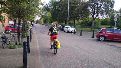
The most interesting thing about the area for me is in the oldest streets. The retrofit has quietly brought some order into what could have been a pretty chaotic car parking arrangement. From the junction of Govanhill Road with Langside Road (above), one can survey a range of interesting design details.
The first thing to note is that the junctions have been narrowed with fairly tight radii and placed on road humps (speed tables) with some surfaced in block paving (some are asphalt). The kerbs are flush here and bollards stand sentinel keep drivers off the footway and help pick out the "safe area" behind the carriageway edge. These days, we'd be looking at the walking desire lines at the junctions and providing appropriate tactile paving.
The extra space at the often includes space opposite at T-junctions (below) which helps keep car parking away from all parts of the junction as well as releasing public space which is often used for tree planting and in the example below, some of this space could be used for other features such as secure cycle parking. The built-out areas mean that car parking is either arranged in parallel to the kerb or perpendicularly, depending on the location.
The simple junction treatments and the use of small element and block paving give a slightly warmer feel to the footway and built-out areas than asphalt and given its age, things are wearing very well indeed.
There are probably some things I might have liked to see done a little differently such as swapping the car parking bay layouts every so often to interrupt the straight carriageway runs (above) and perhaps angling the perpendicular bays in such a way as it encourages (as far as possible) drivers to reverse in as they have a better view as they emerge. I would also have liked to have narrowed the carriageway a little more to push driver speeds down further.
The thing that struck me most as I cycled through the neighbourhood was just how familiar it all seemed. The gentle density, combined with the junction layouts (complete with bollards) felt very familar from my trips around Denmark and The Netherlands where managing car parking in this way is fairly common and it has to leave me wondering if this is where the designers got their inspiration?
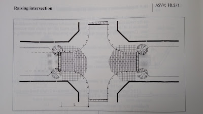
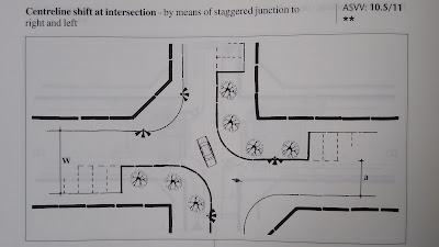
That's not just idle thinking, the techniques used in Govanhill can be found in the Dutch design manual "Recommendations for traffic provisions in built up areas", a huge tome which I love thumbing through for inspiration. Raising junctions is something the UK has done for years, but it appears on the Dutch manual showing the narrowing of the junction complete with bollards and inset car parking bays (above). There's also use made of the perpendicular parking as part of integrated traffic calming which in the image below is used to create a centreline shift at a junction, which is a great technique for breaking a dead straight run.
The final piece of interest for me was trying to date when the layout was built. There won't be a traffic order for the build-outs, but the local traffic filtering can be dated with a traffic order which was proposed in October 1992 and made in May 1993, which means this layout has probably been there for about 30 years. As ever, nothing in highways and traffic engineering is new.
I'll leave you with a little video of a cycle through the area and I would like to thank Alistair McCay for being my local guide and given me so much insight into the area.


This part of the southside is very familiar to me, and indeed, a pleasant area to travel through. Langside Road became the recommended quiet cycle route, parallel to Victoria Rd. Fine if in a hurry, but you miss opportunist shopping. Now we have the segregated South City Way down Victoria Rd, which makes it easier to stop off for a coffee, pick up a few groceries, and enjoy the street life. I'm impatiently awaiting the SCW extension south past Queen's Park to Battlefield and beyond.
ReplyDeleteYes, I enjoyed using SCW and the extension will open up for access for people - mind you, it was a nice place to end the current section at the park.
Delete