
My last trip to the Netherlands was in the Summer of 2017 and because of both Brexit and Covid, I've not been able to visit since. It was therefore fantastic to be able to visit again over the last few days and explore another corner.
My visit was with my son which fulfilled a promise to take him on a Dutch cycling tour, and being car-free, we took out bikes on Greater Anglia to catch the Harwich to the Hook of Holland ferry. From the mainland, our trip would then be on two wheels covering 130km to Rotterdam, Delft and back with a few diversions along the way.
I was a little anxious about the trip after not being on my bike for nearly three weeks after having Covid myself and whilst it has been tiring, the cycling for transport environment is (mainly) great and so I didn't have expend a whole load of energy dealing with drivers and noisy environments (two issues which are almost ignored in the UK).
In the first of a mini-series, I'll have a look at modal filtering on a macro basis which is where you'll discover that the technique is critical to the country's success. Let's start with the obvious - urban areas. Now Rotterdam and Delft couldn't be any more different. Rotterdam is a sprawling and modern city which embraced the car after the Second World War as part of reconstruction, an approach which was probably seen as a bit of a failure by the 1970s and so the city has been trying to reinvent itself, especially in terms of how transport it dealt with every since.

Rotterdam is very much a motor city with wide streets carrying multilane carriageways with large junctions. Above is Westblaak, the street we stayed on which is a dual carriageway complete with a large traffic underpass at its eastern end. It's a busy street at rush hour and it cuts a swathe through the fringe of the city core making access between the Cool District and the area to the south somewhat awkward for walking and cycling. However, once you get off the main roads, you'll start to see that traffic management measures have been deployed to keep through traffic out.
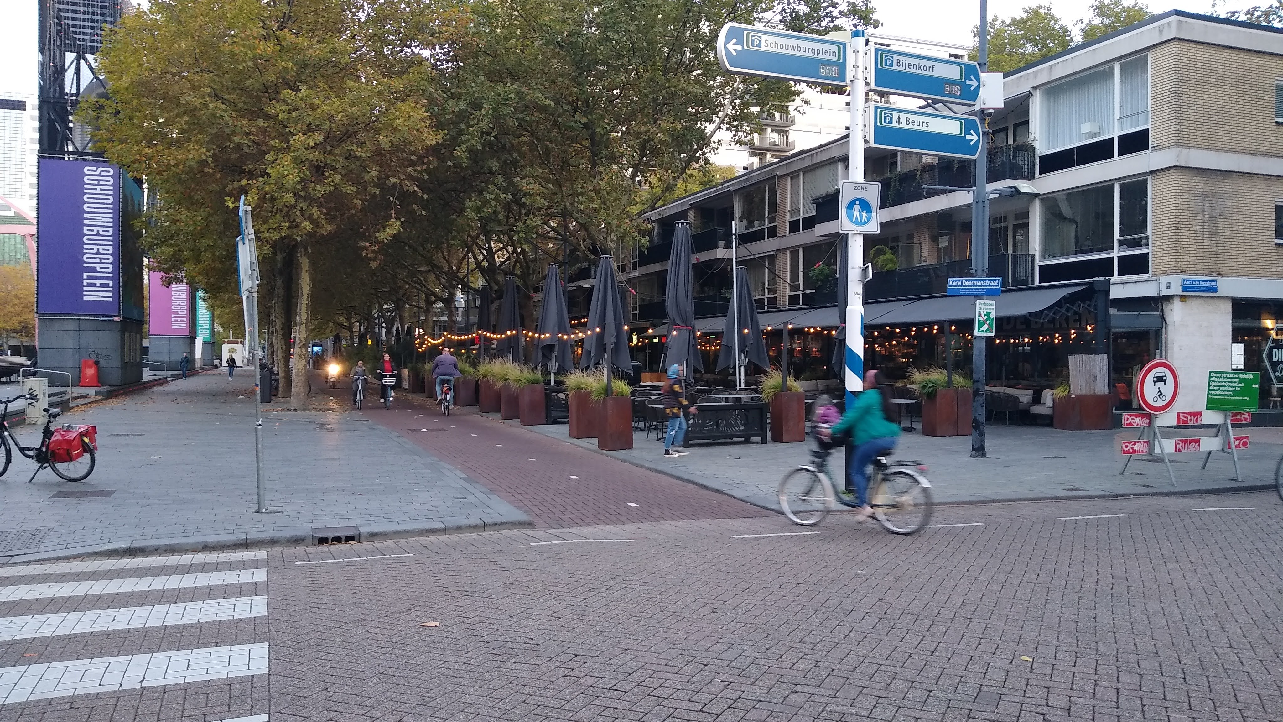
Karel Doormanstraat connects to Westblaak and runs north. What starts as a 2-way street for general traffic quickly becomes one-way (two-way for cycling of course) and it is only really of use for accessing car parks and for deliveries. The street is then pedestrianised with a two-way cycle track providing clear space for cycling (above) - for those who would say this would be terrible for business, I'd say that the packed restaurants say otherwise. To the east of this area there is a pedestrianised shopping centre as well as quiet (and filtered) residential streets.

Running west from Karel Doormanstraat, Mauritsplaats provides local access to a car park, shops and residents and the street becomes another cycle track providing a filter to Mauritsweg / Westersingel, a busier through traffic route straddling a canal. In fact, the first section of cycle track permits very limited traffic access (above) before becoming a cycles only section. Yes, the city's engineers have created a low traffic neighbourhood using one-way streets (with two-way cycling), limited access areas, pedestrianisation, short sections of cycle track and modal filters. This model is replicated all over the city and so while the main roads are busy, the impacts are mitigated away from them.

The main roads in Rotterdam connect to a motorway box which is roughly rectangular and 11km wide by 8km deep and as roads generate (motor) traffic, it wasn't surprising to see traffic jams where the main roads met the the motorway box. One just location was just north of the Van Brienenoordbrug bridge (above) where the extremely busy A16 meets arterial roads to the city. I mention the bridge because it's a great example of where the Dutch use the opportunity to add cycle crossings to existing infrastructure which can be seen below with the additional cycle crossing attached to the side of the road bridge.

I mention this because from a filtering point of view, the cycle bridge connects the areas either side of the Nieuwe Mass river in such as way as to make cycling a convenient mode of transport with general traffic having to go a much longer route to reach those same places. The cycling distance from places either side is about 3km whereas the driven length is double (and assumes there are no traffic jams).
This is where the driving and cycling networks are unbundled and in essence, this is using modal filtering at a much larger scale than we might expect at a neighbourhood level, but the result is the same with access being provided for motors, but by a less convenient route than for cycling. You can walk over the bridge in this case, but the distance is more appropriate for cycling.
The other interesting thing we saw in Rotterdam was linear filtering where service roads have been constructed next to the main roads so that interactions between side streets and main roads are managed. This reduces the "friction" caused by people joining and leaving the main roads and lowers collision risk from drivers slowing down to turn off or having to quickly speed up when joining a main road.

This technique is shown above on Laan Op Zuid which is to the south-east of the city. A one-way service road provides access to shops and homes as part of a wider neighbourhood which uses filters and one-way loops to stop through traffic, or at least makes it undesirable to drive through because of the route you would have to take. The service road here ends with drivers having to join the main road, but cycle traffic continues onto a cycle track and through a protected junction.

So much for the city where it's easy to filter, what about the countryside? Well, our ride from north from Rotterdam to Delft provided plenty of filtering interest. Of course, there were cycle tracks on main roads, but while long distance traffic would be pushed onto the A13, we were able to use sections of residential streets which were filtered long ago such as West-Sidelinge (above) and via cycle tracks through parks such as below where such a layout is joins Willem Hedaweg.

As we left the suburbs, we joined Deftweg which is a key route for cycling between Rotterdam and Delft. Even here, there evidence of network-level filtering to keep through traffic on the A13.

Defltweg itself has rougher block paving with smooth asphalt cycle lanes, the idea being drivers stay in the central (two-way) area and only move into the cycle lanes when they need to. This was probably one of the areas that felt a little more exposed to traffic, but the traffic calming and low flows made it pretty quiet and it felt safe enough, even with a 30mph speed limit. In fact, there were people of all ages cycling along enjoying the countryside.

A little further north and we reached the city limits of the Rotterdam municipality and before the speed limit increased to 50mph, the cycling infrastructure changed to become a two-way cycle track at a "gateway" treatment where drivers entering give way to drivers leaving the area. You can see this in the photograph above in the distance, which also has a floating bus stop serving a small industrial area and you can see the cycle track getting priority over the access to the site. The two-way cycle track after the gateway is shown below.

Then we get to another filtering technique where Delftweg gives way to Rotterdamseweg at a curious set of traffic signals (below). At this location, we had just joined another two-way cycle track after another on-road cycling section after passing through a hamlet where buildings constrained highway space.
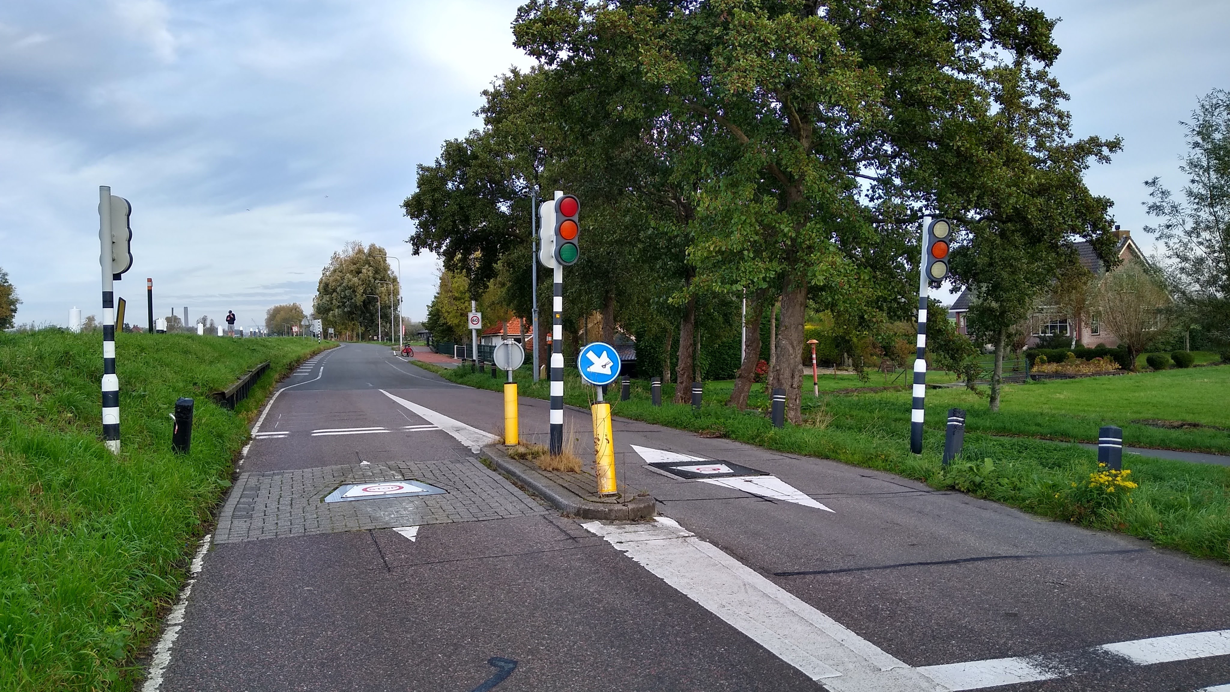
These traffic signals come with tilting bollards which can be used to restrict traffic flow. I don't know how these ones are specifically set up, but my assumption is they are probably used at peak times in the week to make it is waste of time trying to use this rural route to bypass the A13. Alternatively, they might be just needed when there is congestion on the A13. The point is, this is a dynamic filter which allows access for those needing it and which could be set at a maximum flow threshold to provide an appropriate level of risk exposure for people cycling in the area where they have to mix with motor traffic.

Further north and as we approached Delft, we experienced more of the same with a cycle network which sometimes coincided with the motoring network. Sometimes there were cycle tracks next to the main roads and sometimes we were on filtered streets, mixing with what little traffic there was.

At the Delft Campus railway station, we found a brand new walking and cycling underpass (above) which has been built as part of an ongoing rail capacity upgrade in the area. The underpass provides direct access to the station as well as reconnecting the areas either side of the railway and providing a better entrance point (the previous being from near a noisy main road. In this case, the underpass is the filter, with motor traffic having to go a different route.

We then cycled along Schieweg (above) which was undoubtedly the worst piece of our trip for feeling exposed with close passes and lots of HGV traffic. Fortunately it was a short experience and a bit further along, the street changed to a filtered neighbourhood which made use of a cycle street (fietsstraat) shown in the photograph below.

This is essentially a two-way cycle track that can be used for motor vehicle access. The red asphalt signifies the cycle route and provides visual continuity and although the sign says that motors are guests, a cycle street will only work where cycle traffic flows are maybe 3-4 times the amount of motor flows. We turned right across the Abtswoudsebrug bridge which is for walking and cycling only, so yet another filter used to separate out the motoring and cycling networks.

As with Rotterdam, there is lots of filtering going on in Delft and I will cover one particular neighbourhood in a separate post. I started this post with a very wide street and so I shall end it with a very narrow street - Dirklangenstraat - a street giving access between a main road and the centre of Delft, but again it is filtered so the only motors here are those of residents and deliveries/ visitors.

Streets like this make me smile. So often in the UK people tell me that one of the reasons the Dutch do well with cycling is their wide streets where they can fit things in. Dirklangenstraat is a case study in why that is complete nonsense and all it takes to make a little area of city quiet for cycling (and wheeling and walking) is a single orange bollard. Oh, and the political will to do it.
No comments:
Post a Comment